Maps of Poland

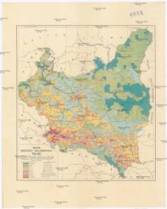
Mapa gęstości zaludnienia Polski
1 : 3000000 Polsko Lencewicz, Stanisław Uniwersytet Warszawski
Mapa samochodowa Polski

Lidová republika polská

Novissima Poloniae Regni Descriptio. [Karte], in: Novus atlas absolutissimus, Bd. 1, S. 90.
1 Karte aus Atlas Janssonius Offizin
87-88. Poland. The World Atlas.
1 : 1500000 USSR (Union of Soviet Socialist Republics).
Polsko, Prusy, Poznáňsko [sic]
1 : 3890000 Polsko
Polonia Regnum, et Silesia Ducatus. [Karte], in: Novus Atlas, das ist, Weltbeschreibung, Bd. 1, S. 73.
1 Karte aus Atlas Blaeu, Joan Blaeu, Willem Janszoon
Polen und Preussen 1240 - 1386
1 : 6000000 Polen, Preußen (Ordensstaat)
Polonia Regnum, et Silesia Ducatus. [Karte], in: Theatrum orbis terrarum, sive, Atlas novus, Bd. 1, S. 102.
1 Karte aus Atlas Blaeu, Joan Blaeu, Willem Janszoon
Polen und Preussen 1140 - 1240
1 : 6000000 Polen, Preußen (Ordensstaat)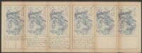
Polonia Regnum, et Silesia Ducatus. [Karte], in: Le théâtre du monde, ou, Nouvel atlas contenant les chartes et descriptions de tous les païs de la terre, Bd. 1, S. 94.
1 Karte aus Atlas Blaeu, Willem Janszoon und Blaeu, Joan Blaeu, Willem Janszoon
Nr. 18b. Hindenburgs Züge
Polen Weltkrieg <1914-1918>, Ostfront
POLONIA | Regnum, et | SILESIA | Ducatus.
Guiljelmus | Blaeu excudit.
Carte du Royaume de Pologne
1 : 900000 Bělorusko Nordmann, A. P. H. Gilly Artaria
Superficie de petites exploitations privées (au-dessous de 50 ha) en proportions pour cent de la superficie générale
1 : 5000000 Polsko w Biurze kartograficznem
Polen unter Boleslaw Chrobry und bis 1139
1 : 12000000 Polen Bolesław I., Polen, König
Novissima Poloniae regni Descriptio
1 : 1600000 Mollova mapová sbírka Janssonius, Johannes Janssonius, Johannes I
Polonia regnvm
Polsko Bouttats, Gaspar
Germany, eastern border regions : administrative divisions
1 : 2570000 Inset: Major administrative divisions. "July 1, 1944, information is shown within the 1937 Germany boundary only." "No. 6275." United States. Office of Strategic Services. Research and Analysis Branch. [Washington, D.C.] : R & A, OSS
Poland, 1:2,000,000
1 : 2000000
Germany, eastern border regions surface configuration
Relief shown by gradient tints. Includes most of western Poland. Includes location map. United States. Office of Strategic Services. Research and Analysis Branch. [Washington, D.C.] : R & A, OSS
Karte vom Herzogthum Warschau, und den angrenzenden Staaten in IV Sectionen
1 : 650000 Polsko Engelhardt, Friedrich Bernhard Mare, Carl Simon Schropp & Comp.

Germany. Deutschland II.
1 : 1760000 Society for the Diffusion of Useful Knowledge (Great Britain)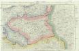
Neue militairische Situations- und Post-Carte von Polen und Preussen
1 : 900650 Polsko Knittel, I. E. Friedrich Campe
Charte des nordöstlichen Deutschlands nebst Preussen u. Polen
Preußen, Kongresspolen
Geschichtl. Entwicklung des Königr. Preussen bis zum Frieden von Tilsit (1807)
Preußen, Polen, Tilsit / Friede
Polonia Et Silesia [Karte], in: Gerardi Mercatoris Atlas, sive, Cosmographicae meditationes de fabrica mundi et fabricati figura, S. 409.
1 Karte aus Atlas Mercator, Gerhard Montanus, Petrus
Polonia Et Silesia [Karte], in: Gerardi Mercatoris et I. Hondii Newer Atlas, oder, Grosses Weltbuch, Bd. 1, S. 340.
1 Karte aus Atlas Mercator, Gerhard und Hondius, Jodocus Jansson, Jan