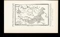
Maps of Pomoravlje District

Südliches Moravatal (Serbien)
1 : 300000 Serbien, Moravatal
Paracin.
from Spezialkarte der osterreichisch-ungarischen Monarchie.
Aleksinac.; Spezialkarte der osterreichisch-ungarischen Monarchie.
from Spezialkarte der osterreichisch-ungarischen Monarchie. Austro-Hungarian Monarchy. Militärgeographisches Institut.,
Carte der von dem Obersten Michalovitz ausgeführten Unternehmung auf Karinovacz am 20. November 178
1 Karte : Kupferdruck ; 12 x 17 cm [Trattner]
Krusevac.; Spezialkarte der osterreichisch-ungarischen Monarchie.
from Spezialkarte der osterreichisch-ungarischen Monarchie. Austro-Hungarian Monarchy. Militärgeographisches Institut.,
Jagodina.; Spezialkarte der osterreichisch-ungarischen Monarchie.
from Spezialkarte der osterreichisch-ungarischen Monarchie. Austro-Hungarian Monarchy. Militärgeographisches Institut.,
Plan okoline Aleksinca
1 : 25000 Srbsko u geografskom odeljenju Glavnog đeneralstaba
Kragujevac
1 : 200000 Kragujevac (Srbsko) Kartografska radionica
Kragujevac
1 : 200000 Kragujevac (Srbsko) Kartografska radionica
Carte des bei Alexinza zwischen dem K. Servischen Freycorps unter Com.-do des Obrist Michaljevich un
1 Karte : Kupferdruck ; 12 x 17 cm [Trattner]
Zagubica.; Spezialkarte der osterreichisch-ungarischen Monarchie.
from Spezialkarte der osterreichisch-ungarischen Monarchie. Austro-Hungarian Monarchy. Militärgeographisches Institut.,
Kragujevac.; Spezialkarte der osterreichisch-ungarischen Monarchie.
from Spezialkarte der osterreichisch-ungarischen Monarchie. Austro-Hungarian Monarchy. Militärgeographisches Institut.,
Generalkarte von Zentraleuropa

Nordost-Serbien
Serbien
Bulgaria
Mollova mapová sbírka Hoffmann, Johannes Hoffmann, Johann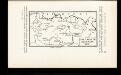
Pachalik de Belgrade 1800
Serbien Osmanisches Reich Belgrad Verwaltungsbezirk
Zemljepis od Serbie
1 : 830000 Srbsko Nipočić, Vasilij u c. k. Politechničeskoj inščotugu
Karta Serbije
1 : 575000 Srbsko Bilic, F. Kocebu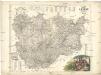
Karta knjažestva Serbie
1 : 375000 Srbsko Bugarski, Iovan Rau, J.
Théatre de la Guerre dans le Bannat de Temeswar
1 : 510000 Mollova mapová sbírka Briffaut, Etienne Briffaut, Etienne
Vermehrte und Verbesserte Landkarten des Königreichs Ungarn :
1 : 500000 Mollova mapová sbírka Stier, Martin Böner, Johann-Alexander Endter, Martin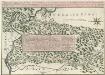
Theatre de la Guerre sur la Timock 1737
Mollova mapová sbírka Briffaut, Etienne Briffaut, Stephan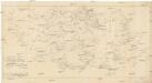
Carte militaire et itineraire du royaume de Servie
1 : 640000 Srbsko Löschenkohl, Johann Hieronymus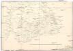
Strassen-Carte der Slawon. Militär-Gränze o. I. u. O
1 : 430000 Srbsko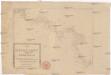
Die Shiffahrt auf der Donau von der Spitze Syrmiens bis in das Schwarze Meer
Bělehrad (Srbsko)
Serbisch-rumänische Grenze
1 : 600000 Banat Grenze
XIX, uit: General-Karte des oesterreichischen Kaiserstaates mit einem grossen Theile der angrenzenden Länder / durch Josef Scheda ... bearb. und hrsg
1 : 576000 Annotatie geografische gegevens: Maatstokken: oesterreichische Meilen, geografische oder deutsche Meilen, preussische Meilen, türkische Berri, französische Lieues, russische Werste; Maatstok per blad: wiener Klafter, öster. Meilen; Blad XIX: statistische en taalkundige informatie; Blad XIX: legenda [Wien : K.K. Militärisch-Geografisches Institut]
Knjažestvo Srbije
1 : 493000 Srbsko Milenkovie, Iovan
Theatrum belli inter imperat. Carol VI. et sult. Achmet IV. in partibus regnorum Serviae et Bosniae
Bulharsko Oettinger, Johann Friedrich Hommanianis Heredibus