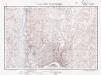
Maps of Borski

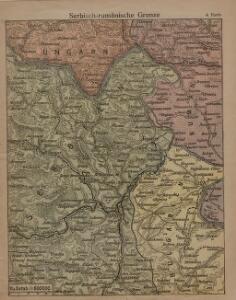
Serbisch-rumänische Grenze
1 : 600000 Banat Grenze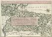
Theatre de la Guerre sur la Timock 1737
Mollova mapová sbírka Briffaut, Etienne Briffaut, Stephan
Zajecar
1 : 200000 Zaječar (Srbsko) Kartografska radionica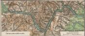
Donaudurchbruch
1 : 500000 Eisernes Tor, Donau (Region)
Carte des bei Negodin vorgefallenen Treffens zwischen den K.K. Truppen unter Com.do des Obristen Lip
1 Karte : Kupferdruck ; 12 x 17 cm [Trattner]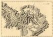
Sectio XIV Widdin - Stanna
Mollova mapová sbírka Marsili, Luigi Ferdinando
Orsova und Turnu-Severin.
from Spezialkarte der osterreichisch-ungarischen Monarchie.
Berzaszka und O-Ogradina.
from Spezialkarte der osterreichisch-ungarischen Monarchie.
Berzászka und Óasszonyrét
1 : 75000 Banat Geripp: Offiz. E. Schill u. Offiz. M. Jakupec. Terrain: Oberlt. C. Mirilović u. Oberlt. R. Machold
Carte des Sieges der K. Truppen unter Com.do des FZ. Gr: Clerfait über die bei Calefat unter Com.do
1 Karte : Kupferdruck ; 12 x 17 cm [Trattner]
Alt-Moldova.
from Spezialkarte der osterreichisch-ungarischen Monarchie.
Paracin.
from Spezialkarte der osterreichisch-ungarischen Monarchie.
Dolnij Milanovac
1 : 75000 Donji Milanovac
Orsova und Turnu-Severin
1 : 75000 Orșova, Drobeta- Turnu Severin Geripp: Oberjgr. J. Richter u. Offiz. M. Jakupec. Terrain: Oberlt. Trica u. Oberlt. Rud. Bayer
Knjazevac.; Spezialkarte der osterreichisch-ungarischen Monarchie.
from Spezialkarte der osterreichisch-ungarischen Monarchie. Austro-Hungarian Monarchy. Militärgeographisches Institut.,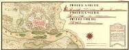
Neies Proiect von Vipalanka von Herren Obrist Lieutinant Rochet dem Hoff Krigs Rath übergeben vnd von den Selben aprobirt MDCCXI
Mollova mapová sbírka Geyer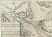
Plan nouveau tres exacte de Vipalanka
Mollova mapová sbírka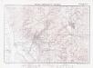
Lambert-Cholesky sheet 1947 (Moldova Veche)
1 : 20000 Romanian military topographic map sheet under Lambert-Cholensky projection Institutul Geografic Militar geo-spatial.org Institutul Geografic Militar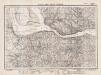
Lambert-Cholesky sheet 1946 (Coronini)
1 : 20000 Romanian military topographic map sheet under Lambert-Cholensky projection Direcția Topografică Militară geo-spatial.org Direcția Topografică Militară
Lambert-Cholesky sheet 2047 (Gârnic)
1 : 20000 Romanian military topographic map sheet under Lambert-Cholensky projection Direcția Topografică Militară geo-spatial.org Direcția Topografică Militară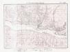
Lambert-Cholesky sheet 2046 (Liubcova)
1 : 20000 Romanian military topographic map sheet under Lambert-Cholensky projection Direcția Topografică Militară geo-spatial.org Direcția Topografică Militară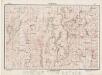
Lambert-Cholesky sheet 2147 (Chiacovatul)
1 : 20000 Romanian military topographic map sheet under Lambert-Cholensky projection Direcția Topografică Militară geo-spatial.org Direcția Topografică Militară
Lambert-Cholesky sheet 2146 (Bigăr)
1 : 20000 Romanian military topographic map sheet under Lambert-Cholensky projection Direcția Topografică Militară geo-spatial.org Direcția Topografică Militară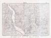
Lambert-Cholesky sheet 2145 (Eibenthal)
1 : 20000 Romanian military topographic map sheet under Lambert-Cholensky projection Direcția Topografică Militară geo-spatial.org Direcția Topografică Militară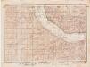
Lambert-Cholesky sheet 2144 (Şviniţa)
1 : 20000 Romanian military topographic map sheet under Lambert-Cholensky projection Direcția Topografică Militară geo-spatial.org Direcția Topografică Militară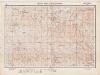
Lambert-Cholesky sheet 2247 (Valea Ieşelniţa)
1 : 20000 Romanian military topographic map sheet under Lambert-Cholensky projection Institutul Geografic Militar geo-spatial.org Institutul Geografic Militar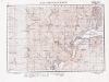
Lambert-Cholesky sheet 2246 (Ogradena Veche)
1 : 20000 Romanian military topographic map sheet under Lambert-Cholensky projection Serviciul Geografic al Armatei geo-spatial.org Serviciul Geografic al Armatei
Lambert-Cholesky sheet 2245 (Plavişeviţa)
1 : 20000 Romanian military topographic map sheet under Lambert-Cholensky projection Direcția Topografică Militară geo-spatial.org Direcția Topografică Militară
Lambert-Cholesky sheet 2244 (Tişoviţa)
1 : 20000 Romanian military topographic map sheet under Lambert-Cholensky projection Direcția Topografică Militară geo-spatial.org Direcția Topografică Militară