Maps of Branicevo District

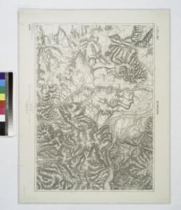
Alt-Moldova.
from Spezialkarte der osterreichisch-ungarischen Monarchie.
Alt-Moldova
1 : 75000 Moldova-Nouă Gemeindegebiet Geripp: Offic. W. Ahl. Terrain: Oberlt. K. Schwarz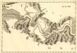
Costalaz - Jetz
Mollova mapová sbírka Marsili, Luigi Ferdinando
Carte der Zugrundrichtung der türk. Tscheiken des Lagers bei Borecz den 16. Sept. 1789
1 Karte : Kupferdruck ; 12 x 17 cm [Trattner]
Lambert-Cholesky sheet 1847 (Vk. Gradiste)
1 : 20000 Romanian military topographic map sheet under Lambert-Cholensky projection Direcția Topografică Militară geo-spatial.org Direcția Topografică Militară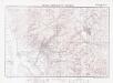
Lambert-Cholesky sheet 1947 (Moldova Veche)
1 : 20000 Romanian military topographic map sheet under Lambert-Cholensky projection Institutul Geografic Militar geo-spatial.org Institutul Geografic Militar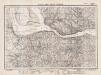
Lambert-Cholesky sheet 1946 (Coronini)
1 : 20000 Romanian military topographic map sheet under Lambert-Cholensky projection Direcția Topografică Militară geo-spatial.org Direcția Topografică Militară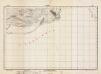
Lambert-Cholesky sheet 1747 (Klicevac)
1 : 20000 Romanian military topographic map sheet under Lambert-Cholensky projection Institutul Geografic al Armatei geo-spatial.org Institutul Geografic al Armatei
Lambert-Cholesky sheet 2047 (Gârnic)
1 : 20000 Romanian military topographic map sheet under Lambert-Cholensky projection Direcția Topografică Militară geo-spatial.org Direcția Topografică Militară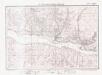
Lambert-Cholesky sheet 2046 (Liubcova)
1 : 20000 Romanian military topographic map sheet under Lambert-Cholensky projection Direcția Topografică Militară geo-spatial.org Direcția Topografică Militară
Karta okružija Požarevačkog knjažestva Serbije
Požarevac (Srbsko) Medoviđ, A. Rerichč, P.
Karta okružija Požarevačkog kiježestva Serbije
1 : 190000 Požarevac (Srbsko) Medoviđ, A. Rerichč, P.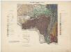
Zone 26, 27, Kol. XXV, Fehértemplom, Szászkabánya und Ómoldova, uit: [Geologische Specialkarte der im Reichsrathe vertretenen Königreiche und Länder der österreichisch-ungarischen Monarchie] / geologische Aufnahmen der königl. ung. Geologischen Anstalt
1 : 75000 Annotatie: Verantwoordelijkheidsvermelding in 1909 veranderd in: Königliche Ungarische Geologische Reichsanstalt; Sommige bladen in het Frans; Annotatie geografische gegevens: Coördinaten gebaseerd op nulmeridiaan van Ferro (Hierro) Königliche Ungarische Geologische Reichsanstalt; Königliche Ungarische Geologische Anstalt Budapest : [Königliche Ungarische Geologische Anstalt]
Weisskirchen und Szaszkabanya.
from Spezialkarte der osterreichisch-ungarischen Monarchie.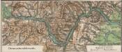
Donaudurchbruch
1 : 500000 Eisernes Tor, Donau (Region)
Petrovac.; Spezialkarte der osterreichisch-ungarischen Monarchie.
from Spezialkarte der osterreichisch-ungarischen Monarchie. Austro-Hungarian Monarchy. Militärgeographisches Institut.,
Weisskirchen und Szászkabánya
1 : 75000 Bela Crkva, Sasca Montanǎ Geripp: Fwkr. Suchánek u. Gfrtr. Tuschell. Terrain: Lieut. Hentke u. Oberlt. Zothe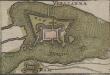
Vipalanka
Banatska Palanka Befestigung
Kostolac Viminacivm
1 : 6500 Kostolac (Srbsko) Papáček, Pavel Florinskij, Timofej Dmitrijevič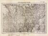
Lambert-Cholesky sheet 1848 (Neramezo)
1 : 20000 Romanian military topographic map sheet under Lambert-Cholensky projection Direcția Topografică Militară geo-spatial.org Direcția Topografică Militară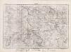
Lambert-Cholesky sheet 1948 (Stinapari)
1 : 20000 Romanian military topographic map sheet under Lambert-Cholensky projection Direcția Topografică Militară geo-spatial.org Direcția Topografică Militară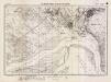
Lambert-Cholesky sheet 1748 (Socol)
1 : 20000 Romanian military topographic map sheet under Lambert-Cholensky projection Serviciul Geografic al Armatei geo-spatial.org Serviciul Geografic al Armatei
Lambert-Cholesky sheet 2048 (Şopotu Nou)
1 : 20000 Romanian military topographic map sheet under Lambert-Cholensky projection Direcția Topografică Militară geo-spatial.org Direcția Topografică Militară
Jižní část krašovské stolice s českými osadami
Banat Tschechen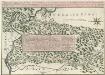
Theatre de la Guerre sur la Timock 1737
Mollova mapová sbírka Briffaut, Etienne Briffaut, Stephan
Nordost-Serbien
Serbien
Bulgaria
Mollova mapová sbírka Hoffmann, Johannes Hoffmann, Johann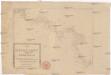
Die Shiffahrt auf der Donau von der Spitze Syrmiens bis in das Schwarze Meer
Bělehrad (Srbsko)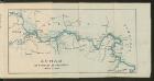
Dunav od Beograda do Radujevca
1 : 750000 Belgrad, Radujevac