Maps of Ukraine
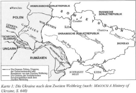
Die Ukraine nach dem Zweiten Weltkrieg
Ukraine Häusler, Ines
Ukraine. Ethnographische Karte des einheitlichen ukrainischen Gebiets ohne Enklaven
1 : 8000000 Ukraine Ethnische Gruppe
Sovětský svaz v mapách

Pflanzengeographische Übersichtskarte der Ukraina
1 : 10000000 Ukraine Pflanzengeografie Kartogr. Anstalt G. Freytag & Berndt, Ges. m. b. H., Wien
Klimatische Übersichtskarte der Ukraina
1 : 10000000 Ukraine Klima Kartogr. Anstalt G. Freytag & Berndt, Ges. m. b. H., Wien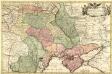
Carte exacte d'une Partie de l'Empire de Russie et de la Pologne meridionale
1 : 2100000 Mollova mapová sbírka Facius, Johann Gottlieb
Tektonisch-morphologische Übersichtskarte der Ukraina
1 : 10000000 Ukraine Geologie Tektonik Kartogr. Anstalt G. Freytag & Berndt, Ges. m. b. H., Wien
Troisième partie de la carte d'Europe contenant le midi de la Russie, la Pologne et la Hongrie, la
1 : 2900000 1 Karte auf 2 Blatt : Kupferdruck ; 52 x 82 cm Anville, Jean Baptiste Bourguignon d' chez l'auteur au galeries du Louvre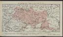
Ethnographische Übersichtskarte der Ukraina
1 : 7500000 Ukraine Ethnische Gruppe Kartogr. Anstalt G. Freytag & Berndt, Ges. m. b. H., Wien
Geologische Übersichtskarte der Ukraina
1 : 10000000 Ukraine Geologie Kartogr. Anstalt G. Freytag & Berndt, Ges. m. b. H., Wien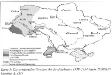
Die territorialen Gewinne der Sowjetukraine 1939-1954
Ukraine Territorium Häusler, Ines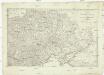
Kriegs Schauplatz zwischen Preussen Russland, der Türkey und Frankreich
Prusko Kunst und Industrie Comp.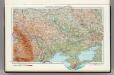
21. Ukrainian SSR, Moldavian SSR. The World Atlas.
1 : 3000000 USSR (Union of Soviet Socialist Republics).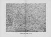
Reliefkarte der Ukraine und Krim
Ukraine, Krim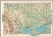
U.S.S.R. - Moldvian, Ukrainian S.S.R. Pergamon World Atlas.
1 : 2500000 Polish Army Topography Service
Ukrania seu Cosacorum Regio Walachia item Moldavia et Tartaria minor / exc. Christ. Weigelio ; M. Ka
1 : 4600000 1 Karte : Kupferdruck ; 33 x 39 cm Kauffer, Michael Weigel
Vkrania quae et terra Cosaccorvm cum vicinis Walachiae, Moldaviae, minoris. Tartariae provinciis
1 : 3250000 Moldavsko Homann, Johann Baptist a Ioh. Baptista Homanno
Vkrania quae et terra Cosaccorvm cum vicinis Walachiae, Moldaviae, minorisq[ue] Tartariae provinciis
1 : 3250000 Moldavsko Homann, Johann Baptist a Ioh. Baptista Homanno
Taurica Chersonesus
1 : 5100000 1 Karte : Kupferdruck ; 13 x 19 cm Mercator, Gerhard [Jean Jansson]
Taurica Chersonesus
1 : 5600000 1 Karte : Kupferdruck ; Mercator, Gerhard [Hondius]
Ukrania quae et Terra Cosaccorum / exhibita à Ioh. Baptista Homanno
1 : 3200000 1 Karte : Kupferdruck ; 46 x 56 cm Homann, Johann Baptist [Homann]
[Ukrajina - vrstevnice a říční síť]
Ukrajina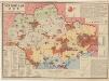
Ukrajinskaja SSR: Osnovnyje objekty promyšlennogo, transportnogo i selskochozjaistvennogo stroitelstva, postroennye i načatye stroitelstvom do načala treťej pjatiletki
Kalmykov, V. A.
Europ. Russland
Stieler's Hand-Atlas Stieler, Adolf bei Justus Perthes
Südliches Blatt vom Europ. Russland
Hand-Atlas über alle Theile der Erde nach dem neuesten Zustande und über das Weltgebäude Stieler, Adolf bei Justus Perthes

[XIV], uit: Geognostische Karte des Oesterreichischen Kaiserstaates mit einem grossen Theile Deutschland's u. Italien / hauptsachlich nach ... Haidinger's geognostischer Karte dieses Staates bearb. von Josef Scheda
1 : 3000000 titelvariant: General-Karte von Europa in 25 Blättern; Annotatie: Bijlage bij: General-Karte von Europa in 25 Blättern. - 1:2.592.000. - 1845-1847 Scheda, Joseph Wien : K.K. Militär. Geografisch. Institut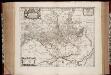
Typus generalis Ukrainae, sive Palatinatuum Podoliae, Kioviensis et Braczlaviensis terras nova delineatione exhibens
1 : 1900000 Annotatie: Linksboven: XII; Origineel is Blad 134 in atlas factice; Annotatie geografische gegevens: Rechtsboven op kaart: zes schaalstokken [S.l. : Ex officina Janssonio-Waesbergiana, et Mosis Pitt]
Amplissima Ucraniae regio, palatinatus Kioviensem et Braclaviensem complectens, cum adjacentibus provinciis
1 : 1825000 juxta recentissimam designationem aeri incisa arte et sumtibus Tobiae Conradi Lotteri, geographi Augustae Vindel [Augsburg], Tobiae Conradi Lotteri