Maps of Scandinavia

[Einwanderung in Reval 1639-1710)
Reval Einwanderung Essen, Nicolai v. ; Eichhorn, Nicolai
Vorstellvng der Sonnen- oder Erd Finsternis den 25 Jul. 1748
1 Karte : Kupferdruck ; 23 x 33 cm, Bildgrösse 48 x 56 cm Lowitz; Dorn Homännische Erben
Vorstellvng der Sonnen- oder Erd Finsternis den 25 Jul. 1748
1 Karte : Kupferdruck ; 23 x 33 cm, Bildgrösse 48 x 56 cm Lowitz; Dorn Homännische Erben
[Evropa - politická mapa]
1 : 3000000 Evropa Paulík, Antonín Klus, František
[Nord- und Istsee]
Atlas der Hydrographie Berghaus, Hermann Justus Perthes
Western Europe. Pergamon World Atlas.
1 : 5000000 Polish Army Topography Service
Quarta Europae Tabula. [Magna Germania] [Karte], in: Claudii Ptolemei viri Alexandrini mathematice discipline philosophi doctissimi geographie opus [...], S. 160.
1 Karte aus Atlas Waldseemüller, Martin [und Ptolemaeus, Claudius] Übelin, Georg
[Einwanderung in Reval 1710-1786)
Reval Einwanderung Gebauer, Victor
North Sea, Baltic cables, wireless stations.
1 : 12500000 Philip, George
Wege-Karte durch den grösten und wichtigsten Theil Europa's
Evropa Schmidt, Johann Marius Friedrich Kliewer, Heinrich Simon Schropp et Comp.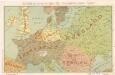
Die Karte von Europa...

Porostní mapa revíru Srbice
1 : 2880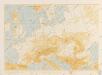
Bez titulu: Povětrnostní mapa Střední Evropy

Carte genérale et itineraire de l'Europe
1 : 2300000 Evropa Traux, Maximilian de Schwarzenberg, Karel Filip Artaria
Die Karte von Europa...
Schiffbare Wasserstrassen in Mitteleuropa
1 : 15000 Evropa střední Oelwein, A.
Part of Europe.
1 : 7200000 Cornell, S. S. (Sarah S.)
Nord- und Ostseeherrschaft I: Reich Knuts des Großen
1 : 12000000 Nordeuropa Knud II., Danmark, Konge
Map of the Post-Route to & from St. Petersburgh
1 : 24000000 Osteuropa Deutschland Polen Russland Reiseweg Postroute
Schweden und Norwegen oder Scandinavische Halbinsel Königr. Daenemark
Geographischer Atlas über alle Theile der Erde Ziegler, Jakob Melchior Verlag von Joh. Wurster um Comp.
Prémière partie de la carte d'Europe contenant la France, l'Alemagne, l'Italie, l'Espagne & les isles britanniq.s, 1
1 Blatt : 53 x 84 cm s.n.
Strassenkarte des Bezirkes Joslowitz

Carte des états slaves rendus indépendants par Samo, et groupés autour de lui (an 625 à 650), en face du royaume réduit des Avars, enserré à l’est par les Khazars et les Bulgares, et au sud et à l’ouest par les Slaves que l’empereur Héraclius avait établis au sud du Danube
Ostmitteleuropa Tschechische Republik Slawen Awaren Samo
Europe
1 : 4000000 Evropa Andriveau-Goujon, E. E. Andriveau-Goujon
Quarta Europe Tabula [Karte], in: [Clavdii Ptholomei Cosmographi ...], S. 260.
1 Karte aus Atlas Nicolaus Germanus [und Ptolemaeus, Claudius]
Germany.
from A new sett of maps both of antient and present geography : wherein not only the latitude and longitude of many places are corrected according to the latest observations, but also the most remarkable differences of antient and present geography may be quickly discern'd by a bare inspection or comparing of correspondent maps, which seems to be the most natural and easy method to lead young students (for whose use the work is principally intended) unto a competent knowledge of the geographical science : together with a geographical treatise particularly adapted to the use and design of these maps / by Edward Wells, M.A. and student of Christ-Church, Oxon.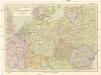
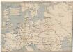
Střední Evropa
1 : 3000000 Evropa střední Kuchař, Karel Janka, Jaromír V. Neubert a synové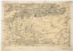
[Centralis Europae]
Evropa střední Schedel, Hartmann
Téatre De La Guerre Des Couronnes du Nord. [Karte], in: Atlas nouveau, contenant toutes les parties du monde [...], Bd. 1, S. 67.
1 Karte aus Atlas Sanson, Nicolas Jaillot, Alexis Hubert und Mortier, Pieter


