Maps of United Kingdom

[Nord- und Istsee]
Atlas der Hydrographie Berghaus, Hermann Justus Perthes
Western Europe. Pergamon World Atlas.
1 : 5000000 Polish Army Topography Service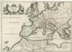
Patriarchatus Romanus
1 : 11100000 Mollova mapová sbírka Sanson, Nicolas Covens, Johannes I
Vorstellvng der Sonnen- oder Erd Finsternis den 25 Jul. 1748
1 Karte : Kupferdruck ; 23 x 33 cm, Bildgrösse 48 x 56 cm Lowitz; Dorn Homännische Erben
Vorstellvng der Sonnen- oder Erd Finsternis den 25 Jul. 1748
1 Karte : Kupferdruck ; 23 x 33 cm, Bildgrösse 48 x 56 cm Lowitz; Dorn Homännische Erben
[Einwanderung in Reval 1639-1710)
Reval Einwanderung Essen, Nicolai v. ; Eichhorn, Nicolai
Prémière partie de la carte d'Europe contenant la France, l'Alemagne, l'Italie, l'Espagne & les isles britanniq.s, 1
1 Blatt : 53 x 84 cm s.n.
Karte von mittel und sued Europa
Evropa Hauslab, Franz von Artaria
Part of Europe.
1 : 7200000 Cornell, S. S. (Sarah S.)
The Mountain Systems of Europe
The physical atlas Johnston, Alexander Keith William Blackwood & Sons
Evropa XIX. století: od vídeňského kongresu r. 1815, do rozhodnutí na frontách světové války r. 1918
Kašpar, Jan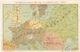
Die Karte von Europa...
Bez titulu: Povětrnostní mapa Střední Evropy

Carte Routiere et Postale de la France

Nová mapa vysílacích stanic Evropy
Evropa Hlaváček, Josef Orbis
North Sea, Baltic cables, wireless stations.
1 : 12500000 Philip, George
Nord- und Ostseeherrschaft I: Reich Knuts des Großen
1 : 12000000 Nordeuropa Knud II., Danmark, Konge
Europe
1 : 4000000 Evropa Andriveau-Goujon, E. E. Andriveau-Goujon
Carte genérale et itineraire de l'Europe
1 : 2300000 Evropa Traux, Maximilian de Schwarzenberg, Karel Filip Artaria
[Einwanderung in Reval 1710-1786)
Reval Einwanderung Gebauer, Victor
Wege-Karte durch den grösten und wichtigsten Theil Europa's
Evropa Schmidt, Johann Marius Friedrich Kliewer, Heinrich Simon Schropp et Comp.
Porostní mapa revíru Srbice
1 : 2880
Carte de la marche des Burgondes
Europa Burgunden Völkerwanderungszeit
Quarta Europae Tabula. [Magna Germania] [Karte], in: Claudii Ptolemei viri Alexandrini mathematice discipline philosophi doctissimi geographie opus [...], S. 160.
1 Karte aus Atlas Waldseemüller, Martin [und Ptolemaeus, Claudius] Übelin, Georg
Kriegszusammenhänge III (1700 - 1721)
1 : 20000000 Europa Nordischer Krieg <1700-1721>, Türkenkriege
Evropa raného středověku: do konce VI. století po Kr.
Kašpar, Jan
Die Karte von Europa...

Carte d'Europe ou sont tracées les limites des empires, royaumes, et etats souverains, feuille 3
1 Blatt : 65 x 95 cm Semen etc
Kriegszusammenhänge V (1788 - 1815)
1 : 20000000 Europa Napoleonische Kriege, Koalitionskriege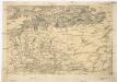
![[Nord- und Istsee]](https://images-0.georeferencer.com/images/iiif/500751340451/full/,300/0/native.jpg)

