Maps of Anatoliki Makedonia kai Thraki

J.8. Adrianopel, uit: [Übersichtskarte von Europa 1:750.000]
1 : 750000 Wien : K.u.K. Militärgeographisches Institut
Adrianopel
1 : 750000 Edirne (Turecko : oblast) Jersche, A. K. u. k. Militärgeographisches Institut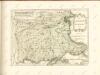

[Philippopel-Adrianopel]
Türkei Bulgarien Osmanisches Reich Balkankrieg <1912-1913> Edirne Mahmud, Muhtar Paşa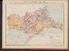
Carte des écoles et églises du vilayet d'Andrinople du sandjak de Tchataldja et de la partie européenne du vilayet de Constantinople (1908)
Türkei Vilâyet Edirne Ejalet Istanbul Sandschak Çatalca Kirchenbau Kümmerly & Frey
[Bulharsko]
1 : 800000 Bulharsko Petr Šafařík, Pavel Josef
Übersichtskarte von Mittel - Europa

Übersichtskarte von Mittel - Europa

[Romanien]
1 Karte : Kupferdruck ; 18 x 13 cm [Trattner]
Sofia, Philippopel
1 : 750000 Plovdiv (Bulharsko : oblast) Czerny, Ed. K. u. k. Militärgeographisches Institut
Sofia, Philippopel
1 : 750000 Plovdiv (Bulharsko : oblast) K. k. militär-geographisches Institut
Sheet XX: Karte Des Oesterreichischen Kaiserstaates.
1 : 576000 Scheda, Josef
Pleven
1 : 200000 Pleven (Bulharsko) Militärgeographisches Institut
Adrianopel
1 : 200000 Edirne (Turecko : oblast) Militärgeographisches Institut
Ėskiz
1 : 1200000 Bulgarien Pleven Russisch-Türkischer Krieg <1877-1878> Schlacht von Pleven
Übersichtskarte
1 : 400000 Türkei Osmanisches Reich Balkankrieg <1912-1913> Mahmud, Muhtar Paşa
Generalkarte von Zentraleuropa

Bulgarisch-rumänische Grenze
1 : 600000 Bulgarien, Rumänien, Grenze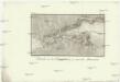
Estrecho de los Dardaneles, y mar de Mármara
Dardanely (Turecko : průliv) Velazques, J. Brieva, S.
Raspoloženīe russkich i tureckich vojsk 29 maja 1829 goda
Bulgarien Russisch-Türkischer Krieg <1828-1829>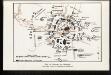
Plan der Belagerung Adrianopel
Türkei Osmanisches Reich Edirne Balkankrieg <1912-1913>
Perechod otrjada Radeckago čerez Balkany
Bulgarien Russisch-Türkischer Krieg <1877-1878> Balkan
Gefechte bei Erikler und Petra am 22. Oktober 1912
Türkei Osmanisches Reich Kırklareli Balkankrieg <1912-1913> Mahmud, Muhtar Paşa
Plan okrěstnostej kr. Šumly
1 : 110000 Šumen (Bulharsko)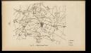
Impresurarea Plevnei
Bulgarien Pleven Russisch-Türkischer Krieg <1877-1878>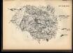
Pervyj boj pod Plevnoj
Bulgarien Pleven Russisch-Türkischer Krieg <1877-1878> Schlacht von Pleven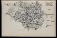
Tretīj boj pod Plevnoj
Bulgarien Pleven Russisch-Türkischer Krieg <1877-1878> Schlacht von Pleven
Kriegslage auf dem rechten Flügel am Nachmittage des 29. Oktober 1912
Türkei Osmanisches Reich Kırklareli Balkankrieg <1912-1913> Mahmud, Muhtar Paşa
Plan glavnym ukrěplenijam kr. Šumly
1 : 110000 Šumen (Bulharsko)
![J.8. Adrianopel, uit: [Übersichtskarte von Europa 1:750.000]](https://images-2.georeferencer.com/images/iiif/454991165140/full/,300/0/native.jpg)

