Maps of East Macedonia and Thrace Region

[Romanien]
1 Karte : Kupferdruck ; 18 x 13 cm [Trattner]
Gallipoli Peninsula (1915)
[A collection of military maps of the Gallipoli Peninsula] / [G.H.Q. M.E.F.]. Great Britain. Army. Middle East Force. General Headquarters. [Cairo] : G.H.Q. M.E.F.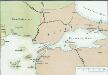
[Konstantinopel]
Istanbul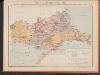
Carte des écoles et églises du vilayet d'Andrinople du sandjak de Tchataldja et de la partie européenne du vilayet de Constantinople (1908)
Türkei Vilâyet Edirne Ejalet Istanbul Sandschak Çatalca Kirchenbau Kümmerly & Frey
J.8. Adrianopel, uit: [Übersichtskarte von Europa 1:750.000]
1 : 750000 Wien : K.u.K. Militärgeographisches Institut
Adrianopel
1 : 750000 Edirne (Turecko : oblast) Jersche, A. K. u. k. Militärgeographisches Institut
[Bulharsko]
1 : 800000 Bulharsko Petr Šafařík, Pavel Josef
Übersichtskarte von Mittel - Europa

Saloniki, Seres, Xanthi, Kastro, Pharsalos
1 : 750000 Fársala (Řecko) Budik, A. K. u. k. Militärgeographisches Institut
Salonik, Seres, Xanthi, Kastro, Phersala
1 : 750000 Soluň (Řecko) K. k. militär-geographisches Institut
Plan Afonskago sraženīja Ījunja 19 dnja 1807 goda
Griechenland Athos Seeschlacht
[Philippopel-Adrianopel]
Türkei Bulgarien Osmanisches Reich Balkankrieg <1912-1913> Edirne Mahmud, Muhtar Paşa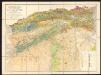
Stalimini I. [Karte], in: Gerardi Mercatoris Atlas, sive, Cosmographicae meditationes de fabrica mundi et fabricati figura, S. 523.
1 Karte aus Atlas Mercator, Gerhard Montanus, Petrus
Archipelagi Insularum Aliquot Descrip., [Stalimene] [Karte], in: Theatrum orbis terrarum, S. 341.
1 Karte aus Atlas Ortelius, Abraham Vrients, Jan Baptista
Archipelagi Insularum Aliquot Descrip., [Stalimene] [Karte], in: Theatrum orbis terrarum, S. 246.
1 Karte aus Atlas Ortelius, Abraham
Prolyv Dardanel'skīj i plan sraženīja maīja 10 1807
Türkei Seeschlacht Dardanellen
Adrianopel
1 : 200000 Edirne (Turecko : oblast) Militärgeographisches Institut
Carte de l'Ile de Lemnos
Limnos, ostrov (Řecko)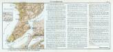
Nr. 14. Die Dardanellenkämpfe. Der Kampfplatz
Dardanellen Weltkrieg <1914-1918>
Ager troianus
Troja
Insular. Aliquot Aegaei Maris Antiqua Descrip.[:] [Lemnos.] [Karte], in: Theatrum orbis terrarum, S. 517.
1 Karte aus Atlas Ortelius, Abraham Vrients, Jan Baptista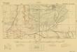
Trench maps of Suvla (provisional) 1:10 000 series (Square 105)
[Trench maps of Suvla (provisional) 1:10 000 series]. Great Britain. Army. Middle East Force. [S.l.] : G.H.Q. M.E.F.
Insular. Aliquot Aegaei Maris Antiqua Descrip.[:] [Lemnos.] [Karte], in: Theatrum orbis terrarum, S. 419.
1 Karte aus Atlas Ortelius, Abraham
Aegean islands - Lemnos, Samos, Mytilini, Methymna, Series MDR 547
Aegean islands - Lemnos, Samos, Mytilini, Methymna, Series MDR 547. Great Britain. Army. Royal Engineers. Field Survey Company, 512th. [Cairo] : [Survey Directorate, Middle East]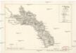
Carte des Berges Athos
Athos (Řecko) Grimm, I. L. Siebert, Selmar
[Dardanellen]
Dardanellen Weltkrieg <1914-1918>
Die Dardanellen
1 : 300000 Dardanellen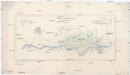
Starit čaltiški dămgi na ENI-ARK
1 : 40000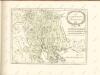

![[Romanien]](https://images-2.georeferencer.com/images/iiif/730333864799/full/,300/0/native.jpg)

