Maps of Somali Peninsula

Blad XXIII Boven Melawi, blad q, uit: Residentie Wester-Afdeeling van Borneo : weg- en rivierkaart / Topographisch Bureau
1 : 50000 Annotatie: Voor aanwezige bladen zie overzichtsblad Topographisch Bureau, Batavia Batavia : Topographisch Bureau
Guinea zwischen Sierra-Leona und dem Aequator
1 : 4110000 Guinejský záliv Anville, Jean-Baptiste Bourguinon d' Schraembl, Franz Anton F.A. Schraembl
Guinea zwischen Sierra-Leona und dem Aequator
1 : 4110000 Guinejský záliv Anville, Jean-Baptiste Bourguinon d' Schraembl, Franz Anton F.A. Schraembl

Guinee, entre Serre-Lione et le passage de La Ligne.
1 : 4150000 Anville, Jean Baptiste Bourguignon d, 1697-1782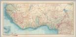
West Africa. Pergamon World Atlas.
1 : 5000000 Polish Army Topography Service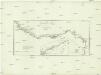
Guinea zwischen Sierra-Leone und dem Aequator
1 : 4120000 Guinea Anville, Jean-Baptiste Bourguinon d' Schraembl, Franz Anton F.A. Schraembl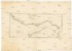
Guinea zwischen Sierra-Leone und dem Aequator
1 : 4120000 Guinea Anville, Jean-Baptiste Bourguinon d' F. A. Schraembl
Carte des possessions anglaises et françaises sur le Golfe de Guinée
1 : 4600000 Paris : impr. de F. Menetrier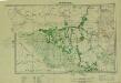
Southern Sudan (1951) Seasonal Cattle Movements
Southern Sudan. Seasonal cattle movements. Corrected Nov. 1951. Topo. No. S919. Khartoum : Sudan Survey Dept.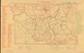
Parliamentary constituencies ― 1957 [Sudan]
Parliamentary constituencies ― 1957 [Sudan]. Sudan. Maṣlaḥat al-Misāḥah. Khartoum : Sudan Survey Department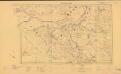
Sudan. Maṣlaḥat al-Misāḥah (1954)
Tribes [Sudan]. Sudan. Maṣlaḥat al-Misāḥah. Khartoum : Sudan Survey Department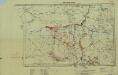
Southern Sudan (1951) Distribution of Population During Wet Season
Southern Sudan. Distribution of population during wet season. Corrected Nov. 1951. Topo. No. S. 918. Khartoum : Sudan Survey Dept.
Royaumes, estats et pays de la Haute Guinée
1 : 9600000 Afrika západní Bonne, Rigobert André
Aequatorial-West-Afrika
1 : 3000000 Kiepert, Richard ; Sprigade, Paul Geographische Verlagshandlung Dietrich Reimer
A chart of coast of BIAFRA from Foche Island to Corisco Island together with the Islands of FERNANDO POO and PRINCES
from The sea-atlas : containing an hydrographical description of most of the sea-coasts of the known parts of the world.
Schutzgebiete Kamerun und Togo [in vier Blättern] Blatt 1
166. West Africa, South. The World Atlas.
1 : 3750000 USSR (Union of Soviet Socialist Republics).
British Somaliland and Sokotra
in British Somaliland and Sokotra. [With a map.] iv, 40 p. ; 8 -- . Great Britain. Foreign Office. Historical Section.
Map of the West Coast of Africa comprising Guinea, and the British possessions at Sierra Leone, on the Gambia and the Gold Coast, together with the countries within the courses of the rivers Senegal, Gambia & Kowara
1 : 3200000 comp. from official documents, by John Arrowsmith London : Arrowsmith
Equatorial West Africa [and] surroundings of Mount Cameroon
Guinea [Karte], in: Le théâtre du monde, ou, Nouvel atlas contenant les chartes et descriptions de tous les païs de la terre, Bd. 2, S. 289.
1 Karte aus Atlas Blaeu, Willem Janszoon und Blaeu, Joan Blaeu, Willem Janszoon
[Overzichtskaart van den Oost-Indischen Archipel]. Bl. I
1 : 2500000 Annotatie: Overige bladen (II-VI) ontbreken [Batavia : Topographische Inrichting]
Gvinea propria nec non Nigritiae vel Terrae Nigrorvm maxima pars, geographis hodiernis dicta ultraq AEthiopia inferior, & hujus quidem pars australis itineri Guineensi D. de Marchais
Afrika západní Anville, Jean-Baptiste Bourguinon d' Hase, Johann Matthias Homannianos Heredes
GVINEA propria nec non NIGRITIAE vel Terrae NIGRORVM maxima pars, geographis hodiernis dicta utraq[ue] AETHIOPIA INFERIOR, & hujus quidem pars australis
1 : 7400000 Afrika západní Anville, Jean-Baptiste Bourguinon d' studio & labore Homannianorum Heredum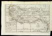
A New Map Of That Part Of Africa Called The Coast Of Guinea
This map has been taken from William Snelgrave's 'A New Account of some parts of Guinea' and shows the area in which Snelgrave - a British sea captain ? traded in slaves. His area of operations is stated as being about 700 leagues (around 2000 miles) from Sherbarow River (Sherbro channel, Sierra Leone) to Cape Lopez Gonsalves (Cape Lopez, Gabon).
Mittel-West-Afrika
Atlas der evangelischen Missions-Gesellschaft zu Basel Locher; Gross, Rudolf Im Verlag des Comptoires der evangelischen Missions-Gesellschaft
Dritter Deutscher Kolonialkongress 1910, Sektion IV, Karte 2

Guinea
1 : 6200000 Amstelaedami : apud Petrum Schenk et Gerardum Valk