Maps of Scandinavia
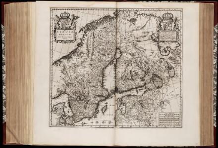
Svecia regnvm / avct. Andrea Bvræo Sveco
1 : 4140000 Annotatie: Kaart van Zweden, Finland en delen van Rusland en de Baltische Zee.; Origineel is Blad 140 in atlas factice; Met opdracht aan Carl (X) Gustavus, Koning van Zweden, door Joan Blaeu; Annotatie geografische gegevens: Met 6 schaalstokken Andreas Bureus 1571-1646 [Amsterdam : Joan Blaeu]

Denmark, Sweden, and Norway.
1 : 7800000 Finley, Anthony
SYNOPSIS PLAGAE SEPTENTRIONALIS sive SUECIAE DANIAE ET NORWEGIAE REGN. accuratissime delineatum
1 : 4500000 Dánsko Seutter, Matthäus studio Matth. Seutteri
Synopsis plagae septemtrionalis sive Sueciae Daniae et Norwegiae regn. accuratissime delineatum
1 : 4500000 Dánsko Seutter, Matthäus Rogg, Gottfried studio Matth. Seutteri
Synopsis plagae septentrionalis sive Sueciae Daniae et Norwegiae regn. accuratissime delineatum
1 : 4500000 Dánsko Seutter, Matthäus studio Matth. Seutteri
Karte des Baltischen Meeres
Baltské moře (oblast) Artaria
Sweden, Denmark, Norway.
1 : 8500000 Darton, William
Sweden & Norway.
1 : 7400000 Mitchell, Samuel Augustus
Sweden & Norway.
1 : 7400000 Mitchell, Samuel Augustus
Suecia Et Norvegia cum sonsiniis [Karte], in: Atlas, sive, Cosmographicae meditationes de fabrica mundi et fabricati figura, S. 128.
1 Karte aus Atlas Mercator, Gerhard
Sweden, Denmark, Norway.
1 : 3720000 Playfair, Principal
Denmark, Sweden, and Norway.
Lavoisne, M.
Homannův atlas světa
1 : 5000000

Scandinavia complectens Sueciæ, Daniæ & Norvegiæ regna
1 Karte : Kupferdruck ; 47 x 54 cm Homann Johann Baptist Homann
Scandinavia complectens Sueciæ Daniæ & Norvegiæ regna
1 Karte : Kupferdruck ; 47 x 55 cm Homann Johann Baptist Homann
Scandinavia complectens Sueciæ, Daniæ & Norvegiæ regna
1 Karte : Kupferdruck ; 47 x 56 cm Homann Johann Baptist Homann
Norsko, Švédsko, Finsko, Estonsko, Lotyšsko a Litva
1 : 7500000 Estonsko Státní nakladatelství

Scandinavien bis zur calmarischen Union, 1397.
1 : 6000000 Spruner von Merz, Karl
Sweden & Norway.
1 : 7600000 Tanner, Henry S.
Sweden & Norway.
1 : 7603200 Tanner, Henry S.
Scandinavien
Neuer Handatlas über alle Theile der Erde Kiepert, Heinrich Verlag von Dietrich Reimer
Exactissima totius Scandinaviae tabula
Skandinávie Visscher, Nicolaes Jansz. Siebert, Selmar per Nicolaum Visscher
Accuratissima regnorum Sueciae, Daniae, et Norvegiae, tabula
1 : 4000000 1 Karte : Kupferdruck ; 49 x 57 cm Danckerts, Justus [Danckerts]
Suede, Danemark.
1 : 4650000 Andriveau-Goujon, J.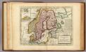
Sweden and Norway.
1 : 9600000 Moll, Herman, d. 1732
Sweden.
1 : 6500000 Bowen, Emanuel