Maps of Scandinavia

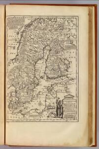
Sweden.
1 : 6500000 Bowen, Emanuel
Norsko, Švédsko, Finsko, Estonsko, Lotyšsko a Litva
1 : 7500000 Estonsko Státní nakladatelství
Denmark, Sweden, and Norway.
1 : 7800000 Finley, Anthony
Denmark, Sweden, and Norway.
Lavoisne, M.
Svecia regnvm / avct. Andrea Bvræo Sveco
1 : 4140000 Annotatie: Kaart van Zweden, Finland en delen van Rusland en de Baltische Zee.; Origineel is Blad 140 in atlas factice; Met opdracht aan Carl (X) Gustavus, Koning van Zweden, door Joan Blaeu; Annotatie geografische gegevens: Met 6 schaalstokken Andreas Bureus 1571-1646 [Amsterdam : Joan Blaeu]
SVECIA | REGNVM
AVCT. ANDREA BVRÆO | SVECO. [Amsterdam : Joan Blaeu]
Denmark, Sweden, Norway.
1 : 7900000 Tanner, Henry S.
Sweden, Denmark, Norway.
1 : 3720000 Playfair, Principal
Scandinavien
Neuer Handatlas über alle Theile der Erde Kiepert, Heinrich Verlag von Dietrich Reimer

Scandinavien bis zur calmarischen Union, 1397.
1 : 6000000 Spruner von Merz, Karl
Scandia, Scandinavia.
1 : 3050000 Faden, William, 1750?-1836
Schweden und Norwegen
E. von Sydow's Schul-Atlas in sechs und dreissig Karten Sydow, Emil von bei Justus Perthes
Sweden & Norway.
1 : 7400000 Mitchell, Samuel Augustus
Sweden & Norway.
1 : 7400000 Mitchell, Samuel Augustus
Zweiter Theil der Karte von Europa welcher Dænemark, und Norwegen, Schweden, und Russland enthælt, 2
1 Blatt : 72 x 54 cm F.A. Schrämbl
Seconde partie de la carte d'Europe contenant le Danemark et la Norwege, la Suède et la Russie (a l'exeption de l'Ukraine), 2
1 Blatt : 71 x 53 cm chez l'auteur
Sweden, Denmark, Norway.
1 : 8500000 Darton, William
Scandinavia.
1 : 4800000 Lizars, Daniel

Nordeuropa 1867
Nordeuropa Kunz, Andreas ; Röss, Wolf ; Johnen, Bettina ; Moeschl, Joachim Robert
Nordeuropa 1949
Nordeuropa Kunz, Andreas ; Treiling, Thomas
Homannův atlas světa
1 : 5000000
Nordeuropa 1820
Nordeuropa Kunz, Andreas ; Röss, Wolf ; Johnen, Bettina ; Moeschl, Joachim Robert
Suede, Norvege, et Danemark.
1 : 5900000 Monin, C.V.
Nordeuropa 1814
Nordeuropa Kunz, Andreas ; Treiling, Thomas
Nordeuropa 1815
Nordeuropa Kunz, Andreas ; Treiling, Thomas
Nordeuropa 1914
Nordeuropa Kunz, Andreas ; Röss, Wolf ; Johnen, Bettina ; Moeschl, Joachim Robert
Sweden and Norway.
1 : 9600000 Moll, Herman, d. 1732