Maps of Scandinavia

Exactissima totius Scandinaviae tabula
Skandinávie Visscher, Nicolaes Jansz. Siebert, Selmar per Nicolaum Visscher
Nieuwe kaart van Noorwegen, Zweden, Denemarken en een gedeelte van Rusland
1 : 12500000 [S.l.] : [s.n.]
Scandinavien bis zum Frieden von Friedrichshamm 1809.
1 : 6000000 Spruner von Merz, Karl
Suecia, Dania, Et Norvegia, Regna Europae Septentrionalia. [Karte], in: Le théâtre du monde, ou, Nouvel atlas contenant les chartes et descriptions de tous les païs de la terre, Bd. 1, S. 55.
1 Karte aus Atlas Blaeu, Willem Janszoon und Blaeu, Joan Blaeu, Willem Janszoon
Scandinavia complectens Sueciæ, Daniæ & Norvegiæ regna
1 Karte : Kupferdruck ; 47 x 54 cm Homann Johann Baptist Homann
Scandinavia complectens Sueciæ Daniæ & Norvegiæ regna
1 Karte : Kupferdruck ; 47 x 55 cm Homann Johann Baptist Homann
Scandinavia complectens Sueciæ, Daniæ & Norvegiæ regna
1 Karte : Kupferdruck ; 47 x 56 cm Homann Johann Baptist Homann
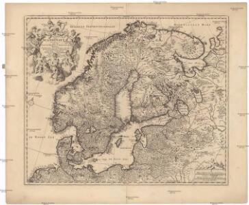
Tabula exactissima Regnorum SUECIAE et NORVEGIAE, nec non MARIS UNIVERSI ORIENTALIS, Terarumq. adjacentium
1 : 5100000 Norsko Bureus, Andreas Goos, Abraham a Nicolao Iohannide Piscatore
[Skandinavien]
Skandinávie
Scandinavia complectens Sueciae, Daniae & Norvegiae regna
1 : 4400000 Dánsko Homann, Johann Baptist Hommanovi dědicové
Scandinavia complectens Sueciae, Daniae & Norvegiae regna
1 : 4400000 Dánsko Homann, Johann Baptist J.B. Homann
SCANDINAVIA complectens SUECIAE, DANIAE & NORVEGIAE REGNA
1 : 4500000 Dánsko Homann, Johann Baptist ex tabulis Ioh. Bapt. Homanni
SCANDINAVIA complectens SUECIAE, DANIAE & NORVEGIAE REGNA
1 : 4500000 Dánsko Homann, Johann Baptist ex tabulis Ioh. Bapt. Homanni
SVECIA, | DANIA, ET NORVEGIA, | Regna Europæ Septentrionalia.
Iuxta Archetypum Andreæ Buræi de Boo, | Secretarij Regij, et supremi Regni Sueciæ | Architecti. [Amsterdam : Joan Blaeu]
Nieuwe kaart van Noord-Europa / door A. de Moor
1 : 3250000 Moor, A. de (fl. 1920) [S.l. : Zijlstra]
Sweden, Denmark, Norway and Finland.
1 : 6400000 Carey, Mathew

Svecia, Dania, Et Norvegia, Regna Europae Septentrionalia [Karte], in: Novus Atlas, das ist, Weltbeschreibung, Bd. 1, S. 39.
1 Karte aus Atlas Blaeu, Joan Blaeu, Willem Janszoon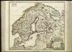
[63][63] Scandinaviae tabula comprehendens Regnorum Sueciae, Daniae et Norvegiae ..., uit: Atlas sive Descriptio terrarum orbis
Annotatie: Gedigitaliseerde versie. Amsterdam. Heiloo : Picturae (vervaardiger), 2015. tiff-bestand. Gedigitaliseerd: 07-01-2015; Origineel: Universiteitsbibliotheek Vrije Universiteit (XL.05127.-) ; Netherlands; Titelpagina ontbreekt Wit, Frederik de Amsterdam : Frederick de Wit
La Scandinavie et les environs, ou sont les royaumes de Suede, de Danemark, et de Norwege
1 : 4800000 Dánsko Sanson, Guillaume Schenk, Pieter chez Pierre Schenk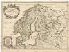
La Scandinavie et les environs
1 : 4800000 Dánsko Sanson, Guillaume Cordier, Louis chez H. Iaillot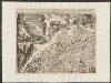
Suecia, Dania, Et Norvegia, Regna Europae Septentrionalia. [...] [Karte], in: Theatrum orbis terrarum, sive, Atlas novus, Bd. 1, S. 53.
1 Karte aus Atlas Blaeu, Joan Blaeu, Willem Janszoon
Tabula exactissima Regnorum Sueciae et Norvegiae, nec non Maris Universi Orientalis [...] [Karte], in: Novus atlas absolutissimus, Bd. 1, S. 45.
1 Karte aus Atlas Janssonius Offizin
Karte des Baltischen Meeres
Baltské moře (oblast) Artaria
Sweden, Denmark, Norway.
1 : 8500000 Darton, William
Sueciae, Norvegiae, et Daniae, Nova Tabula. [Karte], in: Novus atlas absolutissimus, Bd. 1, S. 42.
1 Karte aus Atlas Janssonius Offizin
Accuratissima regnorum Sueciae, Daniae, et Norvegiae, tabula
1 : 4000000 1 Karte : Kupferdruck ; 49 x 57 cm Danckerts, Justus [Danckerts]
Sweden, Denmark, Norway, and Finland from the Best Authorities.
1 : 6550000 Melish, John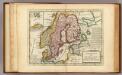
Sweden and Norway.
1 : 9600000 Moll, Herman, d. 1732