Maps of Bani Walid

[XXIII], uit: Geognostische Karte des Oesterreichischen Kaiserstaates mit einem grossen Theile Deutschland's u. Italien / hauptsachlich nach ... Haidinger's geognostischer Karte dieses Staates bearb. von Josef Scheda
1 : 3000000 titelvariant: General-Karte von Europa in 25 Blättern; Annotatie: Bijlage bij: General-Karte von Europa in 25 Blättern. - 1:2.592.000. - 1845-1847 Scheda, Joseph Wien : K.K. Militär. Geografisch. Institut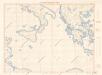
Letecká navigační mapa

Carte De La Mer Mediterranee. VIII.
Roux, Joseph
Feuille 46 (D VII), uit: Carte géologique internationale de l'Europe : la carte, votée au congrès géologique international de Bologne en 1881, est exécutée conformément aux décisions d'une commission internationale, avec le concours des gouvernements, sous le dir. de M.M. Beyrich et Hauchecorne
Annotatie: Blad 48 gamme des couleurs; blad 49: bladwijzer en titelblad Heinrich Ernst Beyrich 1815-1896; Wi. Hauchecorne Berlin : Reimer / (Berlin: Institut lithographique)
Barca. Afrique 4.
1 : 1641836 Vandermaelen, Philippe, 1795-1869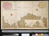
Een gedeelte van de kust van Barbarija beginnende van P. Soliman tot C. Mezurata
Libya Gerard van Keulen
Carte De La Mer Mediterranee. VI.
Roux, Joseph
Partie, Tunis et Tripoli. Afrique 3.
1 : 1641836 Vandermaelen, Philippe, 1795-1869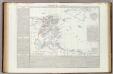
Stato di Tunisi.
1 : 2000000 Marzolla, Benedetto
Eastern Libya, Aerodrome Map
Aerodrome map of Eastern Libya, DR 326. Great Britain. Army. Royal Engineers. Field Survey Company, 512th. [Cairo] : [Survey Directorate, Middle East]
Western Libya, Aerodrome Map
Aerodrome map of Western Libya, DR 326. Great Britain. Army. Royal Engineers. Field Survey Company, 512th. [Cairo] : [Survey Directorate, Middle East]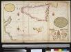
t Eijlandt Sicilia en een gedeelte van de cust van Barbarija met het eijland en haven van Maltha int groot
Italy Gerard van Keulen
Nieuwe Paskaert van de Zee kusten van't Eylandt Sicilia En de tegen over Geleegende Kusten van Barbaria Tusschen C. Bona en I. Zerbi
1 : 940000 Mollova mapová sbírka Keulen, Johannes van Keulen, Gerard van
Tunis, Tripoli.
1 : 2000000 Society for the Diffusion of Useful Knowledge (Great Britain)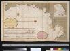
Een gedeelte van de kust van Barbaria tusschen C. Capudia en C. Mesurata int grood
Libya Gerard van Keulen
Tripoli.
1 : 2000000 Society for the Diffusion of Useful Knowledge (Great Britain)
Italy III.
1 : 1770000 Society for the Diffusion of Useful Knowledge (Great Britain)
Ancient Italy III.
1 : 1770000 Society for the Diffusion of Useful Knowledge (Great Britain)
Regnum Moreae accuratissime divisum in provincias Saccaniam, Tzaconiam, Caliscopium et ducatum Clarensae
1 : 590000 Achaia (Řecko) Lotter, Georg F. sumptibus Tobiae Conradi Lotter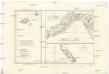
Isles de Madere, de Porto Santo, et celles des Salvages
Madeira (Madeirské souostroví) Bonne, Rigobert André
[General-Karte der Europaeischen Türkei und des Königreiches Griechenland]
1 : 864000 osmanská říše Scheda, Joseph von Artaria & Comp.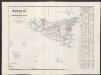
Sicilia ossia reali Dominj al di là del Faro
1 : 840000 Marzolla, Benedetto [Verlag nicht ermittelbar]
Peloponesus hodie Morea ad normam veterum et recentiorum mappar
1 : 900000 Achaia (Řecko) Seutter, Matthäus Matth. Seutter
Southern Greece, with the adjacent Islands
1 : 1100000 Arrowsmith, Aaron Jr.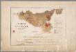
Carta geologica della Sicilia nella scala di 1 a 500.000 ridotto dalle carte a 1:50.000 ed a 1:25.000 / rilevata dal 1877 al 1882 dagli ingegneri del R. Corpo delle miniere
1 : 500000 Annotatie: Opdruk in rood: bladindeling Carta d'Italia 1:100.000 dell' Istit.to Geog.co Militare; Annotatie geografische gegevens: Referentiemeridiaan voor de geografische lengte: meridiaan van Rome; Met 4 profielen op schaal 1:250.000 (horizontaal) en 1:125.000 (verticaal) Corpo delle miniere Roma : R. Stab. Lit. C. Virano
Carta della Sicilia
1 : 786000 Sicílie (Itálie)
Peloponnesus
Peloponnes Verwaltungsgliederung
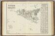
Sicilia.
1 : 870000 Marzolla, Benedetto
![[XXIII], uit: Geognostische Karte des Oesterreichischen Kaiserstaates mit einem grossen Theile Deutschland's u. Italien / hauptsachlich nach ... Haidinger's geognostischer Karte dieses Staates bearb. von Josef Scheda](https://images-2.georeferencer.com/images/iiif/505987273135/full/,300/0/native.jpg)

