Maps of Sirte

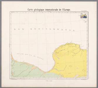
Feuille 46 (D VII), uit: Carte géologique internationale de l'Europe : la carte, votée au congrès géologique international de Bologne en 1881, est exécutée conformément aux décisions d'une commission internationale, avec le concours des gouvernements, sous le dir. de M.M. Beyrich et Hauchecorne
Annotatie: Blad 48 gamme des couleurs; blad 49: bladwijzer en titelblad Heinrich Ernst Beyrich 1815-1896; Wi. Hauchecorne Berlin : Reimer / (Berlin: Institut lithographique)
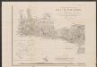
Barca. Afrique 4.
1 : 1641836 Vandermaelen, Philippe, 1795-1869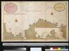
Een gedeelte van de kust van Barbarija beginnende van P. Soliman tot C. Mezurata
Libya Gerard van Keulen
Carte De La Mer Mediterranee. VIII.
Roux, Joseph
Eastern Libya, Aerodrome Map
Aerodrome map of Eastern Libya, DR 326. Great Britain. Army. Royal Engineers. Field Survey Company, 512th. [Cairo] : [Survey Directorate, Middle East]
Tripoli.
1 : 2000000 Society for the Diffusion of Useful Knowledge (Great Britain)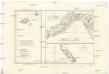
Isles de Madere, de Porto Santo, et celles des Salvages
Madeira (Madeirské souostroví) Bonne, Rigobert André
Egypt and Cyrenaica 1:250,000, Bengasi (Benghazi)
Egypt and Cyrenaica 1:250,000 , Series GSGS 4386. Great Britain. Army. Middle East Command. [London] : War Office.
Egypt and Cyrenaica 1:250,000, Agheila
Egypt and Cyrenaica 1:250,000 , Series GSGS 4386. Great Britain. Army. Middle East Command. [London] : War Office
Egypt and Cyrenaica 1:250,000, Derna
Egypt and Cyrenaica 1:250,000 , Series GSGS 4386. Great Britain. Army. Middle East Command. [London] : War Office
[Kreta Insel]
1 : 50000 Kréta (Řecko : ostrov) Verm-Abt.
Tobruch, Libya 1:50,000
Tobruch 1:50, 000, Series MDR 537. Great Britain. Army. Royal Engineers. Field Survey Company, 512th. [Cairo] : [Survey Directorate, Middle East]
Tobruch, Libya 1:50,000, Acroma
Tobruch 1:50, 000, Series MDR 537. Great Britain. Army. Royal Engineers. Field Survey Company, 512th. [Cairo] : [Survey Directorate, Middle East]
Tobruch, Libya 1:50,000, El Adem
Tobruch 1:50, 000, Series MDR 537. Great Britain. Army. Royal Engineers. Field Survey Company, 512th. [Cairo] : [Survey Directorate, Middle East]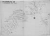
Cyrenaica, Lybia, Baracca
Ente Colonizzazione Libia, comprensorio [district]. One of a collection of maps of districts in Libya; reproduced from Italian originals. [S.l.] : 512 Fd. Survey Co. R.E.
Cyrenaica, Lybia, D'Annunzio
Ente Colonizzazione Libia, comprensorio [district]. One of a collection of maps of districts in Libya; reproduced from Italian originals. [S.l.] : 512 Fd. Survey Co. R.E.
Carta topografica della Cirenaica
1 : 50000 Istituto geografico militare
Cyrenaica, Lybia, Oberdan
Ente Colonizzazione Libia, comprensorio [district]. One of a collection of maps of districts in Libya; reproduced from Italian originals. [S.l.] : 512 Fd. Survey Co. R.E.
Cyrenaica, Lybia, Razza
Ente Colonizzazione Libia, comprensorio [district]. One of a collection of maps of districts in Libya; reproduced from Italian originals. [S.l.] : 512 Fd. Survey Co. R.E.
Cyrenaica, Lybia, Berta
Ente Colonizzazione Libia, comprensorio [district]. One of a collection of maps of districts in Libya; reproduced from Italian originals. [S.l.] : 512 Fd. Survey Co. R.E.
Cyrenaica, Lybia, Luigi Di Savoia
Ente Colonizzazione Libia, comprensorio [district]. One of a collection of maps of districts in Libya; reproduced from Italian originals. [S.l.] : 512 Fd. Survey Co. R.E.
Cyrenaica, Lybia, Mameli
Ente Colonizzazione Libia, comprensorio [district]. One of a collection of maps of districts in Libya; reproduced from Italian originals. [S.l.] : 512 Fd. Survey Co. R.E.
Cyrenaica, Lybia, Battisti
Ente Colonizzazione Libia, comprensorio [district]. One of a collection of maps of districts in Libya; reproduced from Italian originals. [S.l.] : 512 Fd. Survey Co. R.E.
Porto St. Nicolo in I. Serigo
Greece Gerard van Keulen
Porto Serigo
Greece Gerard van Keulen
Archipelagi Insularum Aliquot Descrip., [Cerigo] [Karte], in: Theatrum orbis terrarum, S. 341.
1 Karte aus Atlas Ortelius, Abraham Vrients, Jan Baptista
Cerigo Insul. [Karte], in: Gerardi Mercatoris Atlas, sive, Cosmographicae meditationes de fabrica mundi et fabricati figura, S. 523.
1 Karte aus Atlas Mercator, Gerhard Montanus, Petrus
Archipelagi Insularum Aliquot Descrip., [Cerigo] [Karte], in: Theatrum orbis terrarum, S. 246.
1 Karte aus Atlas Ortelius, Abraham
Carte orographique et géognostique de l'île de Crête (H KPHTH)
1 : 300000 Westblatt Raulin, Victor R. Janson