Maps of Europe
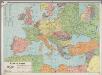
[LL.03966gk: 100/od/1939], uit: Kaart van Europa
1 : 5000000 Annotatie: Met lijst van landennamen (in het Nederlands en in de landstaal) en enkele afstanden naar hemelsbreedte Rotterdam : Spanjersberg
Nouvelle carte de l'Europe dans son état actuel
Evropa Hérisson, Eustache Desray chez Desray
Europa 1964
Europa Kunz, Andreas ; Moeschl, Joachim Robert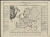
Neue Carte von Europa welche die merkwürdigsten Producte und vornehmsten Handelspläze nebst den Flächen-Inhalt aller Europäischen Länder in deutschen Quadrat-Meilen enthält
1 : 9000000 von A.F.W. Crome T.A. Pingeling sculpsit Hamburg Dessau ; [s.n.]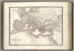
L'Empire Romain.
1 : 10200000 Lapie, M. (Pierre), 1779-1850
Europa Exactissime Descripta [Karte], in: Gerardi Mercatoris et I. Hondii Newer Atlas, oder, Grosses Weltbuch, Bd. 1, S. 30.
1 Karte aus Atlas Mercator, Gerhard und Hondius, Jodocus Jansson, Jan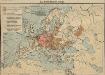
Das Deutschtum in Europa
1 : 36000000 Europa Ethnische Gruppe, Deutsche
Eisenbahn- und Dampfschiffrouten-Karte von Europa
1 : 3000000 Franz, J. Druck und Verlag von Carl Flemming
Europa gegen Ende von Justinians Regierung (um 560 n. Ch. G.)
1 : 15000000 Europa, Mittelmeerraum, Justinian I., Byzantinisches Reich, Kaiser
Carte demonstrative des determinations astronomiques de latitude et d'azimuth
1 : 10000000 Institut topographique militaire
Europe : laid down from the observations of the Royal Academy of Sciences & compared with the maps of Sanson, Nolin, Du Fer, De l'Isle, Moll & other modern geographers ... / [John Bowles] ; engrav'd by Emanuel Bowen
1 : 4500000 Annotatie: Met tabel van Europese lengtematen; Met informatie over de verschillende Europese staten Bowles, John; Bowen, Emanuel London : printed for John Bowles
Europa nach seinen kirchlichen Verhältnissen im Mittelalter
1 : 15000000 Europa Kirchengeschichte
Nova Europae Descriptio [Karte], in: Gerardi Mercatoris Atlas, sive, Cosmographicae meditationes de fabrica mundi et fabricati figura, S. 64.
1 Karte aus Atlas Mercator, Gerhard Montanus, Petrus
Hauptverbindungslinien von Europa als Mittelpunkt des Welverkehrs
Geographischer Atlas über alle Theile der Erde Ziegler, Jakob Melchior Verlag von Joh. Wurster um Comp.
Roman Empire.
1 : 14495100 Fisher, Richard Swainson
Nova et accurate divisa in regna et regiones praecipuas Europae descriptio
1 : 10000000 per F. de Witt Amstelodami [Amsterdam] : ex officina I. Cóvens et C. Mortier
Europa Exactissime Descripta [Karte], in: Novus atlas absolutissimus, Bd. 1, S. 25.
1 Karte aus Atlas Janssonius Offizin
L'Europe, suivant les nouvelles observations de Messrs. de l'Academie Royale des Sciences, etc.
1 : 5100000 augmentées de nouveau Leyde : chez Pierre van der Aa
Europa zur Zeit des dritten Kreuzzuges 1190
1 : 15000000 Europa Kreuzzug <1189-1192>
Völkerkarte von Europa
1 : 36000000 Europa Ethnische Gruppe
Europa.
1 : 38000000 Flemming, Carl
Europa Übersicht der politischen Verhältnisse und Hauptverkehrswege
1 : 20000000 Europa Verkehrsnetz
Europa delineata et recens edita per Nicolaum Visscher. [Karte], in: Novus atlas absolutissimus, Bd. 1, S. 28.
1 Karte aus Atlas Janssonius Offizin
Europa
Neuer Handatlas über alle Theile der Erde Kiepert, Heinrich Verlag von Dietrich Reimer
Europa
1 : 10000000 entworfen und gezeichnet von C. F. Weiland Weimar : Verlag des Geograph. Instituts
Europa
Hypsometrischer Atlas Ziegler, Jakob Melchior Topogr. Anstalt v. J. Wurster u. Comp.
Carte Geologique De L'Europe.
1 : 3800000 Dumont, Andre
Karte von Europa und dem Mittelländischen Meere
1 : 4300000 Evropa Stülpnagel, Friedrich von Bär, Johann Christoph Justus Perthes
Karte von Europa und dem Mittelländischen Meere
1 : 4300000 Evropa Stülpnagel, Friedrich von Bär, Johann Christoph Justus Perthes
![[LL.03966gk: 100/od/1939], uit: Kaart van Europa](https://images-2.georeferencer.com/images/iiif/319635505953/full/,300/0/native.jpg)

