Maps of Europe

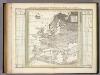
Nouvelle carte de l'Europe dans son état actuel
Evropa Hérisson, Eustache Desray chez Desray
Europa nach seinen kirchlichen Verhältnissen im Mittelalter
1 : 15000000 Europa Kirchengeschichte
Neue Carte von Europa welche die merkwürdigsten Producte und vornehmsten Handelspläze nebst den Flächen-Inhalt aller Europäischen Länder in deutschen Quadrat-Meilen enthält
1 : 9000000 von A.F.W. Crome T.A. Pingeling sculpsit Hamburg Dessau ; [s.n.]
L'Europe en 1860
1 : 7800000 London : Edward Stanford
Europa delineata et recens edita per Nicolaum Visscher. [Karte], in: Novus atlas absolutissimus, Bd. 1, S. 28.
1 Karte aus Atlas Janssonius Offizin
Nova et accurate divisa in regna et regiones praecipuas Europae descriptio
1 : 10000000 per F. de Witt Amstelodami [Amsterdam] : ex officina I. Cóvens et C. Mortier
[Recto], uit: Europa exactissime descripta / auctore Henrico Hondio
1 : 11500000 Annotatie: Uit: L'appendice de l'atlas de Gerard Mercator et Iudocus Hondius ... - Amsterdam : Henry Hondius, 1633; Met opdracht aan Lodewijk XIII Hondius, Henricus Amstelodami : sumptibus auctoris
Europa Exactissime Descripta [Karte], in: Novus atlas absolutissimus, Bd. 1, S. 25.
1 Karte aus Atlas Janssonius Offizin
Europa Exactissime Descripta [Karte], in: Gerardi Mercatoris et I. Hondii Newer Atlas, oder, Grosses Weltbuch, Bd. 1, S. 30.
1 Karte aus Atlas Mercator, Gerhard und Hondius, Jodocus Jansson, Jan
Europa
Allgemeiner Atlas [Walch, Johannes] im Verlag bei Johannes Walch
Europa
Neuester Schul-Atlas Walch, Johann im Verlag bei Joh. Walch
Carte demonstrative des determinations astronomiques de latitude et d'azimuth
1 : 10000000 Institut topographique militaire
Europa 1964
Europa Kunz, Andreas ; Moeschl, Joachim Robert
Nova Europae Descriptio [Karte], in: Gerardi Mercatoris Atlas, sive, Cosmographicae meditationes de fabrica mundi et fabricati figura, S. 64.
1 Karte aus Atlas Mercator, Gerhard Montanus, Petrus
Europa recens descripta [Karte], in: Novus Atlas, das ist, Weltbeschreibung, Bd. 1, S. 22.
1 Karte aus Atlas Blaeu, Joan Blaeu, Willem Janszoon
Europe : laid down from the observations of the Royal Academy of Sciences & compared with the maps of Sanson, Nolin, Du Fer, De l'Isle, Moll & other modern geographers ... / [John Bowles] ; engrav'd by Emanuel Bowen
1 : 4500000 Annotatie: Met tabel van Europese lengtematen; Met informatie over de verschillende Europese staten Bowles, John; Bowen, Emanuel London : printed for John Bowles
EVROPA
recens descripta | à | Guilielmo Blaeuw. [Amsterdam : Joan Blaeu]
Europa
Atlas der Pflanzengeographie über alle Theile der Erde Rudolphi, Ludwig Verlag der Nicolaischen Buchhandlung
L'Europe, suivant les nouvelles observations de Messrs. de l'Academie Royale des Sciences, etc.
1 : 5100000 augmentées de nouveau Leyde : chez Pierre van der Aa
Europa
E. von Sydow's Schul-Atlas in sechs und dreissig Karten Sydow, Emil von bei Justus Perthes
Charte von Europa
1 Karte : Kupferdruck ; 43 x 54 cm Güssefeld bey den Homannis. Erben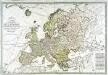
Carte générale de l'Europe
1 Karte auf 2 Blatt : Kupferdruck ; 51 x 75 cm Lotter; Lotter Lotter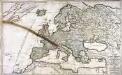
Der Austritt des Mond=Schattens von der Erd=Kugel/ oder das zum Theil eine Finsternuss leidende/ zum Theil davon frey bleibende Europa
1 Karte : Kupferdruck ; 52 x 85 cm Bodenehr zufinden bey Gabriel Bodenehr/ Kupfferst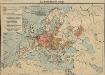
Das Deutschtum in Europa
1 : 36000000 Europa Ethnische Gruppe, Deutsche
Europa
Hypsometrischer Atlas Ziegler, Jakob Melchior Topogr. Anstalt v. J. Wurster u. Comp.
Europa recens descripta [Karte], in: Le théâtre du monde, ou, Nouvel atlas contenant les chartes et descriptions de tous les païs de la terre, Bd. 1, S. 36.
1 Karte aus Atlas Blaeu, Willem Janszoon und Blaeu, Joan Blaeu, Willem Janszoon
General Karte von Europa
1 Karte : Kupferdruck ; 50 x 58 cm von der kön. privileg: Schneider und Weigelschen Kunst und Buchhandlung
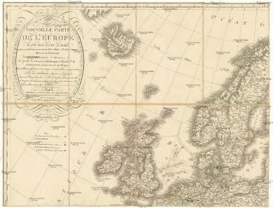
L'Europe dans son etat actuel
1 Karte : Kupferdruck ; 47 x 61 cm Hérisson; Desray; Glot; Picquet chez Desray libraire rue Hautefeuille no. 4, chez Picquet géog.he graveur du cab. topographique de S. M. l'empereur et roi et de S. M. le roi de Hollande quai Malaquais no. 15
Europa mit politischer Begränzung der einzelnen Staaten
Hand-Atlas über alle Theile der Erde nach dem neuesten Zustande und über das Weltgebäude Stieler, Adolf bei Justus Perthes