Maps of Portugal

Feuille 29 (A V), uit: Carte géologique internationale de l'Europe : la carte, votée au congrès géologique international de Bologne en 1881, est exécutée conformément aux décisions d'une commission internationale, avec le concours des gouvernements, sous le dir. de M.M. Beyrich et Hauchecorne
Annotatie: Blad 48 gamme des couleurs; blad 49: bladwijzer en titelblad Heinrich Ernst Beyrich 1815-1896; Wi. Hauchecorne Berlin : Reimer / (Berlin: Institut lithographique)
Neueste Karte von Portugal
Grosser Hand-Atlas über alle Theile der Erde in 170 Karten Meyer, J. Verlag des Bibliographischen Instituts
[Spanien und Portugal in 4 Blättern]
Hand-Atlas über alle Theile der Erde und über das Weltgebäude Stieler, Adolf Justus Perthes
[Spanien und Portugal in 4 Blättern]
Hand-Atlas über alle Theile der Erde nach dem neuesten Zustande und über das Weltgebäude Stieler, Adolf bei Justus Perthes
Carte réduite des costes d'Espagne et de Portugal
1 Karte : Kupferdruck ; 87 x 54 cm Bellin s.n.
Neueste Generalkarte von Portugal und Spanien, 1
1 Blatt : 69 x 51 cm Schrämbl
[Spanien und Portugal in 4 Blättern]
Hand-Atlas über alle Theile der Erde nach dem neuesten Zustande und über das Weltgebäude Stieler, Adolf bei Justus Perthes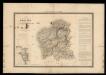
Mapa de Galicia con las nuevas divisiones
1 Mapa. Atlas Nacional de España Dufour, A.H. 0
Spain = España : I
1 mapa. J. & C. Walker sculp. The Society for the Diffusion of Useful Knowledge; Charles Knight & Co
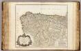
Regnorum Castellæ veteris Legionis et Gallæciæ principatuumque Biscaiæ et Asturiarum accuratissima descriptio, 1
1 Blatt : 48 x 41 cm Visscher
Hispaniæ, et Portugalliæ maritimi tractus, à S. Andero, ad Malagam
1 Karte : Kupferdruck ; 47 x 56 cm Renard Louis Renard
Partie septentrionale de la couronne de Castille
1 Karte : Kupferdruck ; 46 x 57 cm Robert de Vaugondy; Santini; Remondini chez Mr. Remondini
Partie septentrionale de la couronne de Castille
1 Karte : Kupferdruck ; 47 x 58 cm Robert de Vaugondy G. et D. Robert de Vaugondy
Partie septentrionale du royaume de Portugal, les royaumes de Leon et de Galice, les Asturies, partie des deux Castilles [et]c
1 Karte : Kupferdruck ; 44 x 56 cm Jaillot; Dezauche chez Dezauche géog. rue des Noyers près celle des Anglois
Spain & Portugal - western section.
1 : 2000000 John Bartholomew and Son
A new Military Map of Spain and Portugal compiled from The Nautical Surveys of Don Vincent Tofiño, the new Provincial maps of Don Tomas Lopez, the large map of the Ptrenees by Roussill, and various original documents
1 Mapa en 4 seccions dins d'un estoig. John Stockdale J. Stockdale
[8][8] Regnorum Castellae Veteris, Legionis, et Gallaeciae..., uit: Atlas sive Descriptio terrarum orbis
Annotatie: Gedigitaliseerde versie. Amsterdam. Heiloo : Picturae (vervaardiger), 2015. tiff-bestand. Gedigitaliseerd: 07-01-2015; Origineel: Universiteitsbibliotheek Vrije Universiteit (XL.05127.-) ; Netherlands; Titelpagina ontbreekt Wit, Frederik de Amsterdam : Frederick de Wit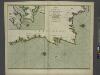
The coasts of PORTUGALL and part of SPAIN from cape finifterre to Gibralter
from The sea-atlas : containing an hydrographical description of most of the sea-coasts of the known parts of the world.
Le Portugal et ses rontieres avec l'Espagne / par ordre de M. le duc de Choiseul par le Sr. Bellin
1 Mapa, b/n. Datació aproximada. Bellin, Jacques Nicolas Dépôt de la Marine
Novissima et accuratissima tabula, quâ Gallæciæ et Legionis regna, Asturiarum principa.tus Portugalliæ tractus septentrionalis
1 Karte : Kupferdruck ; 46 x 58 cm Ottens; Ottens R. et J. Ottens
Espagne et Portugal. Flle. N.O.
1 : 1250000 Vivien St Martin, L.
Portugall.
from A new systeme of the mathematicks: containing I. Arithmetick, as well natural and decimal, as in species, or the principles of algebra. II. Practical geometry, together with the first six books of Euclid's Elements, as also the eleventh and twelfth, symbo
Partie, l'Espagne. Europe 18.
1 : 1641836 Vandermaelen, Philippe, 1795-1869
Portugalliæ et Algarbiæ regna
1 Karte : Kupferdruck ; 45 x 55 cm Visscher Nicolaes Visscher
Portugalliae et Algarbiae Regna / per Nicolaum Visscher
1 : 1500000 Annotatie: Cum privilegio ordinum Hollandiæ et West-Frisiæ; Origineel is Blad 6 in atlas factice; Annotatie geografische gegevens: Met 3 schaalstokken; Legenda Nicolaes Jansz. Visscher jr. 1649-1702 [Amsterdam : Nicolaes Visscher]
Corona Portugalliae cum ei affinibus Regnis Hispanicis : Don Pedro generosissimo regi Portugalliae dedicatur
1 : 1100000 per Jacobum Robyn Amst. Bat. Luggerdus van Anse schulp. Amst. Bat. : per Jacobum Robyn
Portugalliae et Algarbiae Regna
1 : 1500000 per Nicolaum Visscher [Amsterdam] : nunc apud Petrum Schenk Junior
Portugalliæ et Algarbiæ regna
1 Karte : Kupferdruck ; 48 x 56 cm Seutter Matthäus Seutter
Portugalliæ et Algarbiæ cum finitimis Hispanniæ regnis
1 Karte : Kupferdruck ; 48 x 54 cm Homann Johann Baptist Homann