Maps of Mediterranean Sea

[Das Mittellaendische und Schwarze Meer, Auch als General Karte des Osmanischen Reichs]
Hand-Atlas über alle Theile der Erde nach dem neuesten Zustande und über das Weltgebäude Stieler, Adolf bei Justus Perthes
[Das Mittellaendische und Schwarze Meer. Auch als General Karte des Osmanischen Reichs]
Hand-Atlas über alle Theile der Erde nach dem neuesten Zustande und über das Weltgebäude Stieler, Adolf bei Justus Perthes
Imperium Romanum Antiquum
Römisches Reich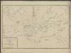
[Hierographie, oder topographisch-synchronistische Darstellung der Geschichte der christlichen Kirche] : II. Von Paulus bis Origines
1 : 8400000 W.A. Möller Lith. bey Arnz & Co. in Düsseldorf Elberfeld : Büschler
[Hierographie, oder topographisch-synchronistische Darstellung der Geschichte der christlichen Kirche] : V. Von Constantin bis auf Gregor d. G. J. 325-604
1 : 8400000 W.A. Möller Lith. bey Arnz & Co. in Düsseldorf Elberfeld : Büschler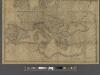
A new map of Europe exhibiting its natural and political divisions drawn from the most recent materials
From Whole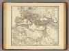
Imperium Romanum inde a bello Actiaco usque ad Diocletiani tempus.
1 : 15000000 Menke, Th.
[Hierographie, oder topographisch-synchronistische Darstellung der Geschichte der christlichen Kirche] : III. Origines - Nicaea
1 : 8400000 W.A. Möller Lith. bey Arnz & Co. in Düsseldorf Elberfeld : Büschler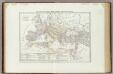
Carta generale dell'Impero Romano sotto Costantino.
1 : 11500000 Marzolla, Benedetto
Das Römische Reich in der Kaiserzeit
starověký Řím Gindely, Antonín F. Tempsky
Gemälde der grossen Wanderungen der Barbaren
Historisch-genealogisch-geographischer Atlas von Le Sage Las Cases, Emmanuel Auguste Dieudonné Marius Joseph de Johann Velten, Kunsthändler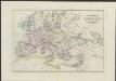
[Historisch-geographischer Atlas zu den allgemeinen Geschichtswerken von C. v. Rotteck, Pölitz u. Becker] : Uebersichts-Karte für das Zeitalter Napoleons
von Julius Loewenberg Lithographie von B. Herder in Freiburg im Breisgau [Freiburg im Breisgau] : [Herder]
Imperium Romanum tempore Constanitini Magni
1 : 23720000 Afrika severní Luther, E. Verlag der geographischen Anstalt des Bibliographischen Instituts zu Hildburghausen und Neu-York
Imperium Romanum tempore Constantini Magni
Středomoří
[Hierographie, oder topographisch-synchronistische Darstellung der Geschichte der christlichen Kirche] : I. Zeiten der Apostel
1 : 8400000 W.A. Möller Lith. bey Arnz & Co. in Düsseldorf Elberfeld : Büschler
[Hierographie, oder topographisch-synchronistische Darstellung der Geschichte der christlichen Kirche] : VI. Von Constantin bis auf Gregor d. G. J. 325-604
1 : 8400000 W.A. Möller Lith. bey Arnz & Co. in Düsseldorf Elberfeld : Büschler
TABLEAU DE LA TRANSMIGRATION DES BARBARES
Evropa Las Cases, Emmanuel-Auguste-Dieudonné Didot, Pierre Jules Didot Ainé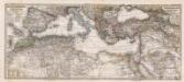
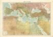
Composite: Mittellandische Meer, Nord-Afrika.
1 : 7500000 Petermann, A.
Imperium Romanum.
1 : 15000000 Kiepert, Heinrich, 1818-1899
[Hierographie, oder topographisch-synchronistische Darstellung der Geschichte der christlichen Kirche] : IV. Von Constantin bis auf Gregor d. G. J. 325-604
1 : 8400000 W.A. Möller Lith. bey Arnz & Co. in Düsseldorf Elberfeld : Büschler
Gemaelde des Roemischen Reichs in seiner grösten Ausdehnung
Historisch-genealogisch-geographischer Atlas von Le Sage Las Cases, Emmanuel Auguste Dieudonné Marius Joseph de Johann Velten, Kunsthändler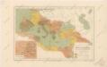
Říše římská ve své největší rozsáhlosti

Carte des peuples de l’Europe centrale lors de l’apparation des Huns, au 4e siècle de notre ère
Mitteleuropa ethnische Gruppe, Völkerwanderungszeit
Verbreitung der Religionen im Anfange von Justinians Regierung
1 : 30000000 Europa Justinian I., Byzantinisches Reich, Kaiser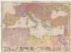
Mittelmeerländer
1 : 4000000 Afrika severní Georg Westermann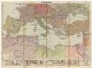
Mittelmeerländer
1 : 4000000 Afrika severní Georg Westermann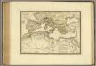
Nord de l'Afrique, Mer Mediterranee, Europe Meridionale.
1 : 9300000 Brue, Adrien Hubert, 1786-1832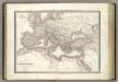
L'Empire Romain.
1 : 10200000 Lapie, M. (Pierre), 1779-1850
![[Das Mittellaendische und Schwarze Meer, Auch als General Karte des Osmanischen Reichs]](https://images-2.georeferencer.com/images/iiif/185078044519/full/,300/0/native.jpg)

