Maps of Europe

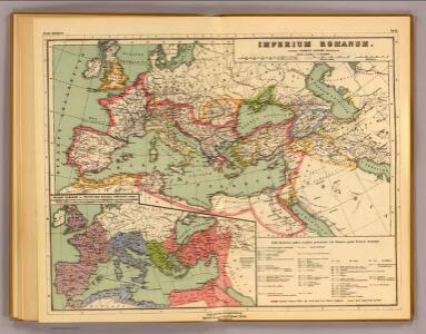
Imperium Romanum.
1 : 15000000 Kiepert, Heinrich, 1818-1899
Gemälde der grossen Wanderungen der Barbaren
Historisch-genealogisch-geographischer Atlas von Le Sage Las Cases, Emmanuel Auguste Dieudonné Marius Joseph de Johann Velten, Kunsthändler
Carta generale dell'Impero Romano sotto Costantino.
1 : 11500000 Marzolla, Benedetto
Imperium Romanum inde a bello Actiaco usque ad Diocletiani tempus.
1 : 15000000 Menke, Th.
Empire Romain.
1 : 10800000 Andriveau-Goujon, J.
Terre aux trois fils de Noe.
1 : 23500000 Houze, Antoine Philippe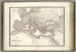
L'Empire Romain.
1 : 10200000 Lapie, M. (Pierre), 1779-1850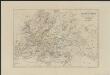
[Historisch-geographischer Atlas zu den allgemeinen Geschichtswerken von C. v. Rotteck, Pölitz u. Becker] : Übersichtskarte für die Geschichte vom Ende der Kreuzzüge bis zur Reformation
von Julius Loewenberg Lithographie von B. Herder in Freiburg im Breisgau 1836 [Freiburg im Breisgau] : [Herder]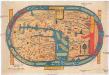
S. Beati Liebanensis Mappam mundi
země světa Miller, Konrad Otto Maier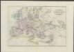
[Historisch-geographischer Atlas zu den allgemeinen Geschichtswerken von C. v. Rotteck, Pölitz u. Becker] : Uebersichts-Karte für das Zeitalter Napoleons
von Julius Loewenberg Lithographie von B. Herder in Freiburg im Breisgau [Freiburg im Breisgau] : [Herder]
Verbreitung der Religionen im Anfange von Justinians Regierung
1 : 30000000 Europa Justinian I., Byzantinisches Reich, Kaiser
Imperium Romanum tempore Constanitini Magni
1 : 23720000 Afrika severní Luther, E. Verlag der geographischen Anstalt des Bibliographischen Instituts zu Hildburghausen und Neu-York
Europa Post Bellum Triginta Annorum. (1650-1700)
Europa Westfälischer Friede
Europa. Staaten
1 : 24000000 Europa Politische Geografie
Das Römische Reich in der Kaiserzeit
starověký Řím Gindely, Antonín F. Tempsky
A new map of Europe exhibiting its natural and political divisions drawn from the most recent materials
From Whole
Carte des peuples de l’Europe centrale lors de l’apparation des Huns, au 4e siècle de notre ère
Mitteleuropa ethnische Gruppe, Völkerwanderungszeit
Imperium Romanum tempore Constantini Magni

Europa nach seinen ethnographischen Verhältnissen in der Mitte des XIX Jahrhunderts
1 : 15000000 Europa ethnische Gruppe
Europam, Sive Celticam Veterem [Karte], in: Theatrum orbis terrarum, S. 362.
1 Karte aus Atlas Ortelius, Abraham
Romani Imperii Imago. [Karte], in: Theatrum orbis terrarum, S. 451.
1 Karte aus Atlas Ortelius, Abraham
[Historisch-geographischer Atlas zu den allgemeinen Geschichtswerken von C. v. Rotteck, Pölitz u. Becker] : Uebersichts-Karte für die Geschichte von der Völkerwanderung bis auf Carl den Grossen
von Julius Loewenberg Lithographie von B. Herder in Freiburg im Breisgau 1836 [Freiburg im Breisgau] : [Herder]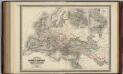
Roman Empire at the Time of Christ.
1 : 12300000 Johnson, A.J.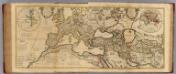
Composite: Imperii Romani.
1 : 8500000 L'Isle, Guillaume de, 1675-1726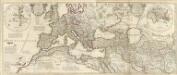
Theatrum historicum ad annum Christi quadringentesimu. in quo tum Imperii Romani tu.
1 : 8500000 L'Isle, Guillaume de, 1675-1726

Europa zur Zeit Napoleon's I. (um 1810)
1 : 15000000 Europa Napoleon I., Frankreich, Kaiser
Zur Völkerwanderung
1 : 30000000 Europa Völkerwanderung
TABLEAU DE LA TRANSMIGRATION DES BARBARES
Evropa Las Cases, Emmanuel-Auguste-Dieudonné Didot, Pierre Jules Didot Ainé