Maps of Columbia Plat.

[Die Vereinigten Staaten von Amerika in 6 Blättern, Blatt 1]
Adolf Stieler's Handatlas über alle Theile der Erde und über das Weltgebäude Stieler, Adolf Justus Perthes
[Die Vereinigten Staaten von Nord-Amerika, Blatt 1]
Handatlas über alle Theile der Erde und über das Weltgebäude Stieler, Adolf Justus Perthes
Vereinigte Staaten Von Nord-Amerika In 6 Blattern, Bl. 1.
1 : 3700000 Petermann, A.
California, Territories of Oregon, Washington, Utah, New Mexico.
1 : 6800000 Mitchell, Samuel Augustus
California, Territories of Oregon, Washington, Utah, New Mexico.
1 : 6800000 Mitchell, Samuel Augustus
Western States road map.
1 : 1362240 Standard Oil Company of California
Map Of Oregon And Upper California.
1 : 3000000 Fremont, J.C.
(United States) Denver to Pacific Coast.
1 : 3802000 Rand McNally and Company
Bancroft's Map Of The Pacific States.
1 : 1520640 Knight, W.H.
Oregon, Washington, California, Utah, and New Mexico.
1 : 7303000 Fisher, Richard Swainson
Rand - McNally Official Railway Map Of The Pacific Coast States Including Territory East To Denver
1 : 1393920 Rand McNally and Company
Commercial Map, Denver to Pacific Coast.
1 : 3950000 Rand McNally and Company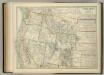
United States of North America (North West Sheet).
1 : 3984000 Johnston, W. & A.K.
Map of Oregon, Washington and part of Idaho.
from New general atlas.
Soil Map of the United States, Section 4. Atlas of American Agriculture.
1 : 2500000 Marbut, Curtis F.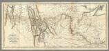
Map of Lewis and Clark's Track...
1 : 4450000 Lewis, Meriwether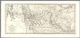
Map of Lewis and Clark's Track, Across the Western Portion of North America .
1 : 4300000 Allen, Paul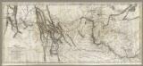
Map of Lewis and Clark's Track, Across the Western Portion of North America .
1 : 4300000 Lewis, Meriwether
Map of the Gold Regions of California, Showing the Routes via Chagres and Panama, Cape Horn, &c.
Ensigns & Thayer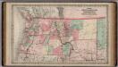
Oregon and Washington Territory.
1 : 3000000 Colton, G.W.
Sectional map indicating main automobile roads between Canada and United States
1 : 2534400 Kanada západní National Development Bureau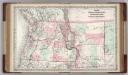
Oregon, Washington, Idaho, Montana, British Columbia.
1 : 3000000 Colton, G.W.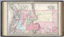
The State of Oregon and Washington Territory.
1 : 3000000 Colton, G.W.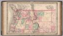
Oregon, and Washington Territory.
1 : 3000000 Colton, G.W.
Oregon, Upper California & New Mexico.
1 : 6600000 Tanner, Henry S.
Map of an exploring expedition to the Rocky Mountains in the year 1842 and to Oregon & north California in the years 1843-44 / by Brevet Capt. J.C. Frémont of the Corps of Topographical Engineers under the orders of Col. J.J. Abert, Chief of the Topog...
From Parts
Montana, Wyoming, Colorado, Idaho, Utah, Nevada.
1 : 2246000 Rand McNally and Company
Road map Idaho, Mont., Wyo.
1 : 1774080 Texas Company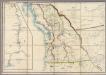
Map of the Oregon Territory
Wyld, James, 1812-1887
![[Die Vereinigten Staaten von Amerika in 6 Blättern, Blatt 1]](https://images-2.georeferencer.com/images/iiif/703467848165/full/,300/0/native.jpg)

