Maps of Great Basin

Map of an exploring expedition to the Rocky Mountains in the year 1842 and to Oregon & north California in the years 1843-44 / by Brevet Capt. J.C. Frémont of the Corps of Topographical Engineers under the orders of Col. J.J. Abert, Chief of the Topog...
From Parts
Oregon, Upper California & New Mexico.
1 : 6600000 Tanner, Henry S.
Bancroft's Map Of The Pacific States.
1 : 1520640 Knight, W.H.
Western States road map.
1 : 1362240 Standard Oil Company of California
Map Of Oregon And Upper California.
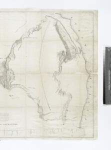
1 : 3000000 Fremont, J.C.
Map of the Gold Regions of California, Showing the Routes via Chagres and Panama, Cape Horn, &c.
Ensigns & Thayer
Rand - McNally Official Railway Map Of The Pacific Coast States Including Territory East To Denver
1 : 1393920 Rand McNally and Company
United States W., NE.
1 : 5000000 Andree, Richard; Times (London, England)
Pacifischen Staaten der Union.
1 : 5000000 Andree, Richard
Commercial Map, Denver to Pacific Coast.
1 : 3950000 Rand McNally and Company
California, Oregon & Nevada with Part of Idaho, Utah & Arizona.
1 : 4642000 Schonberg & Co.
County map California; Map of the settlements in the Great Salt Lake country, Utah [inset] ; San Francisco Bay and vicinity [inset].
from New general atlas.
California, Nevada, Oregon.
1 : 2000000 Williamson, R.S.
Californien, Oregon, Utah, Neu-Mejico.
1 : 5100000 Flemming, Carl
Map of California and Nevada, with parts of Utah & Arizona
1 : 1500000 United States. Army. Corps of Engineers United States. Army. War Dept.
Map Of California And The Adjacent Country.
1 : 1800000 Goodwin, F.A.
Vereinigte Staaten Von Nord-Amerika In 6 Blattern, Bl. 1.
1 : 3700000 Petermann, A.
[Die Vereinigten Staaten von Nord-Amerika, Blatt 1]
Handatlas über alle Theile der Erde und über das Weltgebäude Stieler, Adolf Justus Perthes
[Die Vereinigten Staaten von Amerika in 6 Blättern, Blatt 1]
Adolf Stieler's Handatlas über alle Theile der Erde und über das Weltgebäude Stieler, Adolf Justus Perthes
Location of Indian lands in California (132 reservations).
Includes index of reservations by jurisdiction. United States. Resettlement Administration. Land Utilization Division. Land-Use Planning Division. California Unit
Significant population movements in non-urban areas, 1930-1935
"Survey made and map compiled in 1936."|~|Shows areas with increases or decreases of 10 or more families.|~|California Unit, Land-Use Planning Section, Land Utilization Division, Resettlement Administration.|~|UCLA Catalog Record United States. Resettlement Administration. Land Utilization Division. Land Use Planning Section. California Unit. The Unit
Soil Map of the United States, Section 4. Atlas of American Agriculture.
1 : 2500000 Marbut, Curtis F.
140-41. Calif., Nev., Utah, Ariz.
1 : 3000000 Touring club italiano
Nuova California ; Baie di Monterey e di Francisco.
1 : 4600000 Marzolla, Benedetto
Railroad map of Oregon, California, and Nevada.
1 : 2508000 Gray, Ormando Willis
Rand McNally Junior Road Map California and Nevada.
1 : 3548160 Rand McNally and Company
Pacific Coast subjects.
1 : 7800000 United States. Census Office
State Of California.
1 : 3453120 Rogers, Henry Darwin
Map Of California And Nevada.
1 : 1500000 U.S. War Department, Chief of Engineers
Geomorphic map, California, Nevada, portions of Oregon, Idaho.
1 : 1900000 California. State Earthquake Investigation Commission