Maps of Polynesia

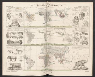
Geographische Verbreitung
Zweiter Band, enthaltend in vier Abtheilungen die Vertheilung der Organismen: 5. Pflanzen-Geographie, 6. Thier-Geographie, 7. Anthropographie, 8. Ethnographie Humboldt, Alexander von Verlag von Justus Perthes
3. Atlas des ganzen Erdkreises.
1 : 61000000 Reichard, C. G.
Geographische Verbreitung.
1 : 108000000 Berghaus, Heinrich
Australien (Südland) auch Polynesien oder Inselwelt, insgemein der fünfte Welttheil genannt : nach den neuesten und bewährtesten Hülfsmitteln entworfen
1 : 22000000 Augsburg : Walch
L'Australe
1 : 40000000 W.C. v. Baarsel sculp. [S.l.] : [s.n.]
Le globe terrestre presenté d'une maniere nouvelle, et plus avantageuse pour avoir sous un meme coup d'oeil la situation respective, et le rapport des grandeurs de toutes ses parties
země světa Lirelli, Salvador
Océanie ou cinquième partie du monde
1 : 29450000 carte encyprotype réduite de celle sur 4 feuilles du même auteur par A. Brué [...] Paris : chez Ch. Picquet
Les câbles anglais
1 : 80000000 Léon de Montarlot; Le monde illustré Paris : Le Monde illustré
[141][144] Magnum Mare del Zur cum Insula California ..., uit: Atlas sive Descriptio terrarum orbis
Annotatie: Gedigitaliseerde versie. Amsterdam. Heiloo : Picturae (vervaardiger), 2015. tiff-bestand. Gedigitaliseerd: 07-01-2015; Origineel: Universiteitsbibliotheek Vrije Universiteit (XL.05127.-) ; Netherlands; Titelpagina ontbreekt Wit, Frederik de Amsterdam : Frederick de Wit
Oceanien
Geographischer Atlas über alle Theile der Erde Ziegler, Jakob Melchior Verlag von Dietrich Reimer
Generale Ptholemei [Karte], in: Claudii Ptolemei viri Alexandrini mathematice discipline philosophi doctissimi geographie opus [...], S. 148.
1 Karte aus Atlas Waldseemüller, Martin [und Ptolemaeus, Claudius] Übelin, Georg
Afrique : d'après les documents les plus récents et les derniers traitès
1 : 18000000 Giffault, E Le Temps Bureaux
Australien
1 : 26000000 gezeichnet von J.M.F. Schmidt gestochen von H. Brose Berlin : bei Simon Schropp et Comp.
[Neuer Atlas der ganzen Erde nach den neuesten Bestimmungen ... : VII.] Australien
Bearbeitet u. gezeichnet von F.W. Streit Leutemann sc. Leipzig : J.C. Hinrichssche Buchhandlung
Die Samoa-Inseln und die gegenwärtigen Besitzverhältnisse der Kolonialstaaten im Indischen- und Grossen Ocean
1 : 25000000 Dietrich Reimer
Carte particulière de La Polynésie : parties orientale et septentrionale de L'Océanie [...]
1 : 23150000 réd. par A. H. Brué [...] d'aprés l'ensemble des matériaux recueillis jusqu'à ce jour, 1826 [...] Paris : chez Chles. Picquet
Australien
Neuer Handatlas über alle Theile der Erde Kiepert, Heinrich Verlag von Dietrich Reimer
Polynesia.
1 : 95000000 Fenner, Rest.
Oceanien
Geographischer Atlas über alle Theile der Erde Ziegler, Jakob Melchior Verlag von Joh. Wurster um Comp.
Oceanien
[Allgemeiner Atlas über alle Theile der Erde in 29 Blättern] Ziegler, Jakob Melchior Top. Anstalt v. J. Wurster u. Comp.
[Polynesien und der Grosse Ocean, westliches Blatt]
Handatlas über alle Theile der Erde und über das Weltgebäude Stieler, Adolf Justus Perthes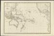
Carte de l'Océanie ou cinquième partie du monde
1 : 26450000 par A. H. Brué, Geographe de S.A.R. Monsieur A Paris [etc.] : [chez J. Goujon, Rue du Bac, No. 6, près le Pont Royal, [etc.]
Magnum Mare del Zur cum insula California
1 Karte : Kupferdruck ; 49 x 55 cm Renard by L. Renard
Australien
Neuester Schul-Atlas Walch, Johann im Verlag bei Joh. Walch
[Recto], uit: Australië en Oceanië / [aardrijksk. medew. G.J. de Vries]
1 : 68000000 titelvariant: Australië (en Oceanië); Annotatie: Titel boven krt. en op verso: Australië (en Oceanië); Verso: statistische gegevens voornaamste staatkundige gebieden; Annotatie geografische gegevens: Inzet: Indonesië. - 1:54.000.000 Gerben Johannes de Vries 1886-1968 Sneek : Tonnema
Polynesia, Or Islands In The Pacific Ocean.
1 : 42000000 Tallis, J. & F.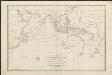
Carte réduite de la Mer des Indes, et d'une partie de celle du sud : pour la relation du voyage à la recherche de la Pérouse, du Cen. Labillardière
1 : 27750000 dressée par J. D. Barbié Du Bocage, an VIIIème de la République D'houdan sculpsit ; Dien scripsit [Paris] : [s.n.]
Ocean Atlantique et Ocean Indien.
1 : 50000000 Vivien St Martin, L.
Australien
Stieler's Hand-Atlas Stieler, Adolf bei Justus Perthes