Maps of Polynesia

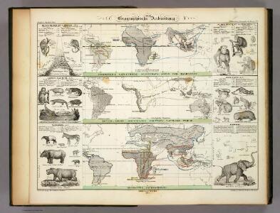
Geographische Verbreitung.
1 : 108000000 Berghaus, Heinrich
Afrique : d'après les documents les plus récents et les derniers traitès
1 : 18000000 Giffault, E Le Temps Bureaux
Les câbles anglais
1 : 80000000 Léon de Montarlot; Le monde illustré Paris : Le Monde illustré
Generale Ptholemei [Karte], in: Claudii Ptolemei viri Alexandrini mathematice discipline philosophi doctissimi geographie opus [...], S. 148.
1 Karte aus Atlas Waldseemüller, Martin [und Ptolemaeus, Claudius] Übelin, Georg
Océanie ou cinquième partie du monde
1 : 29450000 carte encyprotype réduite de celle sur 4 feuilles du même auteur par A. Brué [...] Paris : chez Ch. Picquet
Ocean Atlantique et Ocean Indien.
1 : 50000000 Vivien St Martin, L.
Pacific Ocean : compiled from Admiralty surveys & other official sources
1 : 15000000 India-Rubber, Gutta-Percha & Telegraph Works Co J.D. Potter
Carta generale dell'America settentrionale
1 : 25000000 Marzolla, Benedetto Real Litografia Militare
Asia
Hand-Atlas über alle Theile der Erde und über das Weltgebäude Stieler, Adolf Justus Perthes
[Islas filipinas - pacifico]
Atlas de Filipinas Algué, P. José Government Printing Office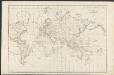
Allgemeine Weltcharte
1 : 45400000 nach Mercators Projection entworfen von A.I. Krusenstern, Capitain der Russischen Marine J. Walker sculpt. ; verb. bis zum Jahre 1818. London : [s.n.]
Asia
Stieler's Hand-Atlas Stieler, Adolf bei Justus Perthes
Orbis Terrarum Veteribus Cogniti Typus Geographicus. [Karte], in: Novus atlas absolutissimus, Bd. 10, S. 8.
1 Karte aus Atlas Janssonius Offizin
Nieuwe kaart van het oostelykste deel der weereld, dienende tot aanwyzing van de scheepstogten der Nederlanderen naar Oostindië : volgens de laatste ontdekkingen
Te Amsterdam : by Is. Tirion
Geographische Verbreitung
Zweiter Band, enthaltend in vier Abtheilungen die Vertheilung der Organismen: 5. Pflanzen-Geographie, 6. Thier-Geographie, 7. Anthropographie, 8. Ethnographie Humboldt, Alexander von Verlag von Justus Perthes
[Karte vom Grossen Ocean, Zur Übersicht der Strömungen, Temperatur und Handels-Strassen]
Erster Band, enthaltend in vier Abtheilungen die Erscheinungen der anorganischen Natur: 1. Meteorologie und Klimatographie. 2. Hydrologie und Hydrographie. 3. Geologie. 4. Tellurischer Magnetismus Humboldt, Alexander von Verlag von Justus Perthes
Magnum Mare del Zur cum insula California
1 Karte : Kupferdruck ; 49 x 55 cm Renard by L. Renard
[Verbreitung der vorzüglicheren Säugethiere in der neuen Welt]
Zweiter Band, enthaltend in vier Abtheilungen die Vertheilung der Organismen: 5. Pflanzen-Geographie, 6. Thier-Geographie, 7. Anthropographie, 8. Ethnographie Humboldt, Alexander von Verlag von Justus Perthes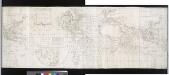
A correct chart of the terraqueous globe, according to Mercator's, or more properly Wright's projection, on which are describ'd lines, shewing the variation of the magnetic needle according to observations made about the year 1744.; Accuratissima totius terrarum orbis tabula nautica / celeberrimo viro Edmd. Halley, LLD., anno 1700 contructa; indice variationes magneticas denota[m?] ad observationes circiter annu 1744 habitas renovata Gulielmo Mountaine et Jacobo Dodson.
from Charts and maps Halley, Edmund; Mountaine, Guielmo; Dodson, Jacobo,
Schlegel's Versuch Einer Schlangen-Karte.
1 : 165000000 Berghaus, Heinrich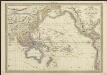
Carte de l'Océanie comprenant l'Australie, la Polynésie et du Grand Archipel d'Asie
1 : 37000000 dressée par Hérisson, géographe gravé par J. B. Tardieu ; Pelicier scrip. Paris : chez Jean, Rue St. Jean-de-Beauvais, No. 10
Vertheilung der Luftströmungen
země světa Gräf, C. Dellinger, A. Geographisches Institut
Physical Chart of the Pacific Ocean
The physical atlas Johnston, Alexander Keith William Blackwood & Sons
II. Charte für die allgemeine Geschichte von Troja’s Zerstörung bis auf den Anfang der Perserkriege : d.i. von 1184 bis 501 vor Christus
Entworfen von F.W. Benicken Weimar : im Verlage des L. Industrie-Comptoirs
[Zoological Geography, Geographical Division and Distribution of Reptilia (Reptiles)]
The physical atlas Johnston, Alexander Keith William Blackwood & Sons
Vergleichendes Tableau der Länge der Ströme und der Grösse der Seen der Erde in geograph. Meilen zu 15 am Grad
země světa Desjardin, Constantin J. Bermann
Asia
Hand-Atlas über alle Theile der Erde nach dem neuesten Zustande und über das Weltgebäude Stieler, Adolf bei Justus Perthes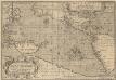
Maris Pacifici, (quod vulgò Mar del Zur) cum regionibus circumiacentibus [...] [Karte], in: Theatrum orbis terrarum, S. 64.
1 Karte aus Atlas Ortelius, Abraham Vrients, Jan Baptista
[Polynesien und der Grosse Ocean (westliches Blatt)]
Adolf Stieler's Handatlas über alle Theile der Erde und über das Weltgebäude Stieler, Adolf Justus Perthes