Maps of United States

Vereinigte Staaten von Nord-America
Stieler's Hand-Atlas Stieler, Adolf bei Justus Perthes
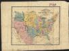
Nord Americanische Freistaaten
Schul-Atlas in 36 Karten Völter, Daniel Verlag der J.M. Dannheimer'schen Buchhandlung
Vereinigte Staaten von Nord-America
Hand-Atlas über alle Theile der Erde nach dem neuesten Zustande und über das Weltgebäude Stieler, Adolf bei Justus Perthes
Nord-Americanische Freistaaten
Grosser Hand-Atlas über alle Theile der Erde in 170 Karten Meyer, J. Verlag des Bibliographischen Instituts
Military map of the United States
1 : 5000000 Freyhold, Edward United States. War Dept.
United States Of North America.
1 : 6336000 Stanford, Edward
Etats-Unis.
1 : 11700000 Migeon, J.
Etats Unis.
1 : 10000000 Vivien St Martin, L.
Railroad Map Of The United States.
1 : 3801600 Rand McNally and Company
[Map of Spanish Louisiana and the American colonies]
from Whole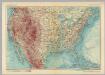
United States of America. Pergamon World Atlas.
1 : 10000000 Polish Army Topography Service
Map of the United States of America with its territories & districts : including also a part of upper & lower Canada and Mexico.
from Whole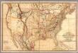
Fredonia Or The United States of North America.
1 : 570000 Laurie, Richard Holmes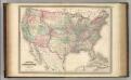
United States.
1 : 8800000 Johnson, A.J.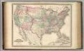
United States.
1 : 8800000 Johnson, A.J.
[Vereinigte Staaten von Nord-America und Canada]
Schul-Atlas über alle Theile der Erde nach dem neuesten Zustande, und über das Weltgebäude Stieler, Adolf bei Justus Perthes
Map of the United States of North America: with parts of the adjacent countries / by David H. Burr (late topographer to the Post Office), geographer to the House of Representatives of the U.S.
from Whole David H. Burr,

Map of the United States and Mexico: including Oregon, Texas and the Californias.
from Parts s.n.: [New York?],
Vereinigte Staaten Von Nordamerika
The United States : the relative position of the Oregon & Texas and California
1 : 19000000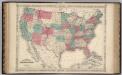
United States.
1 : 8652000 Johnson, A.J.
Geognostische Karte der Nord-Americanischen Freistaaten
Grosser Hand-Atlas über alle Theile der Erde in 170 Karten Meyer, J. Verlag des Bibliographischen Instituts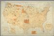
Map showing the location of the Indian reservations within the limits of the United States and territories / compiled from official and other authentic sources, under the direction of the Hon. John D.C. Atkins, Commissioner of Indian Affairs ; Paul Brodi
from Whole
Hypsometric sketch US.
1 : 10400000 United States. Census Office
United States / Geo. Boynton, sc., Boston.
from Whole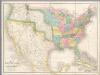
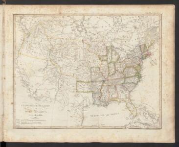
Map of the United States Of North America.
1 : 4118400 Burr, David H., 1803-1875
Vereinigte Staaten von Nord-America
1 : 13000000
Map of the United States, constructed from the latest authorities / J.H. Young, sc.
from Whole