Maps of Norway

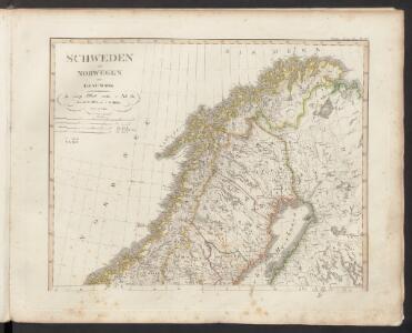
Schweden und Norwegen auch Daenemark
Stieler's Hand-Atlas Stieler, Adolf bei Justus Perthes
Schweden und Norwegen auch Daenemark, Nördliches Blatt]
Hand-Atlas über alle Theile der Erde nach dem neuesten Zustande und über das Weltgebäude Stieler, Adolf bei Justus Perthes
Courones du nord.
1 : 2500000 L'Isle, Guillaume de, 1675-1726
Statistikk 26-2c: Hornkvæg. Antal Dyr pr 1000 Maal høstet Areal
1 : 2400000
Northern Sweden and Frontier of Russia.
1 : 3380000 Sharpe, J.
Jordbunnskart
1 : 2000000 Juel Låg Norges Landbrukshøgskole | Norges geografiske oppmåling
Statistikk 26-1b: Hovedsæden i hvert Herred
1 : 2400000
Statistikk 26-6c: Hornkvæg. Middeltal pr Gaard
1 : 2400000
Statistikk 26-8b: Avling af Korn
1 : 2400000
Statistikk kart 13-b: Norvège. Division ecclesiastique
1 : 2400000
Statistikk 26-10b: Eng i Procent af den dyrkede Jord, fogderivis
1 : 2400000
Statistikk 26-2b: Herreder, hvis Kornavl er tilstrækkelig til eget Brug
1 : 2400000
Statistikk kart 15a: Norvège. Division militaire
1 : 2400000
Statistikk 26-6b: Udsæd af Korn
1 : 2400000
Statistikk 26-3c: Faar. Antal Dyr pr 1000 Maal høstet Areal
1 : 2400000
Spesielle kart 72a: Kart over Valgmands- og Stortingsvalgene
1 : 2400000 K. Petersen Olaf Norli's forlag; Kristiania
Ost-Europa In 6 Blattern, Enthaltend: Norwegen, Schweden, Russland, Kaukasien Und Die Turkei .
1 : 3700000 Petermann, A.
Statistikk kart 14: Norvège. Division médicale
1 : 2400000
Statistikk kart 20-4: Fremstilling af den norske Fædrift. Faaret. Dyrenes antal pr 1000 maal afhøstet areal
1 : 2400000
Statistikk 26-9c: Husdyrene reduceret til Hornkvæg for hver Gaard
1 : 2400000
Statistikk kart 3: Folkemængdekart over Norge
1 : 1600000
Statistikk 26-4b: Avling reduceret til Bygværdi.
1 : 2400000
[Ost-Europa in 6 Blättern, Enthaltend: Norwegen, Schweden, Russland, Kaukasien und die Türkei, Blatt 1]
Hand-Atlas über alle Theile der Erde und über das Weltgebäude Stieler, Adolf Justus Perthes
Statistikk kart 19-4: Fremstilling af Norges Agerbrug. Engdyrkning. Eng beregnet i procent af dyrket areal
1 : 2400000
Spesielle kart 5-2: Telegraf Kart over Norge
1 : 2000000
Statistikk 26-5c: Heste. Middeltal pr Gaard
1 : 2400000
Atlas für Industrie- und Handelsgeographie: Für commercielle und technische Lehranstalten, für Kaufleute und Industrielle

Spesielle kart 66-2: Kart udvisende de med bidrag af Statskassen understøttende Dampskibsrouter
1 : 2400000