Maps of Scandinavia

Spesielle kart 72a: Kart over Valgmands- og Stortingsvalgene
1 : 2400000 K. Petersen Olaf Norli's forlag; Kristiania
Jordbunnskart
1 : 2000000 Juel Låg Norges Landbrukshøgskole | Norges geografiske oppmåling
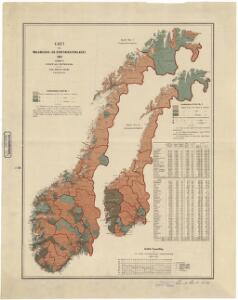
Statistikk 26-1b: Hovedsæden i hvert Herred
1 : 2400000
Statistikk 26-2c: Hornkvæg. Antal Dyr pr 1000 Maal høstet Areal
1 : 2400000
Statistikk 26-10b: Eng i Procent af den dyrkede Jord, fogderivis
1 : 2400000
Statistikk 26-8b: Avling af Korn
1 : 2400000
Statistikk 26-6c: Hornkvæg. Middeltal pr Gaard
1 : 2400000
Statistikk 26-6b: Udsæd af Korn
1 : 2400000
Statistikk kart 14: Norvège. Division médicale
1 : 2400000
Statistikk 26-3c: Faar. Antal Dyr pr 1000 Maal høstet Areal
1 : 2400000
Statistikk kart 20-4: Fremstilling af den norske Fædrift. Faaret. Dyrenes antal pr 1000 maal afhøstet areal
1 : 2400000
Statistikk kart 15a: Norvège. Division militaire
1 : 2400000
Atlas für Industrie- und Handelsgeographie: Für commercielle und technische Lehranstalten, für Kaufleute und Industrielle

Statistikk 26-2b: Herreder, hvis Kornavl er tilstrækkelig til eget Brug
1 : 2400000
Statistikk kart 21-2: Norvege. Pêches.
1 : 2400000
Statistikk kart 13-b: Norvège. Division ecclesiastique
1 : 2400000
Statistikk 26-9b: Avling reduceret til bygværdi pr. indbygger, fogderivis
1 : 2400000
Statistikk 26-9c: Husdyrene reduceret til Hornkvæg for hver Gaard
1 : 2400000
Statistikk kart 19-6: Fremstilling af Norges Agerbrug. Hovedsæden i hvert Herred
1 : 2400000
Statistikk 26-1c: Heste. Antal Dyr pr 1000 Maal høstet Areal
1 : 2400000
Statistikk 26-7b: Udsæd af Poteter
1 : 2400000
Statistikk 26-7c: Faar. Antall Dyr pr 1000 Maal høstet Areal
1 : 2400000
Statistikk 26-2a: Grundeiendommenes Udstykning i Klasser
1 : 2400000
Statistikk kart 4-2: Kart udvisende Folkemængens fordeling i Norge
1 : 2400000
Statistikk kart 19-5: Fremstilling af Norges Agerbrug. Potetsavlen. Udsæd beregnet pr 1000 maal ager
1 : 2400000
Statistikk kart 19-4: Fremstilling af Norges Agerbrug. Engdyrkning. Eng beregnet i procent af dyrket areal
1 : 2400000
Statistikk 26-3b: Fremstilling af Kongeriget Norges Landbrug. Agerbruget
1 : 2400000
Statistikk 26-5c: Heste. Middeltal pr Gaard
1 : 2400000
Statistikk kart 13-a: Norvège. Division ecclesiastique
1 : 2400000