Maps of Appalachian Mountains

Östliches Nordamerica
Neuer Handatlas über alle Theile der Erde Kiepert, Heinrich Verlag von Dietrich Reimer
Map of the United States and Canada : shewing Captn. Hall's route through those countries in 1827 & 1828 / engraved on steel by W.H. Lizars.
from Parts
Wyld's Military Map Of The United States.
1 : 4500000 Wyld, James, 1812-1887
Carte des Etats-Unis

Map of the United States / by J.H. Young ; engraved by J.H. Young, D. Haines & F. Dankworth.
from Whole
United States or Fredon / H.G. Spafford, del. ; G. Fairman sc.
from General geography, and rudiments of useful knowledge. In nine sections ... Illustrated with an elegant improved plate of the solar system ... a map of the world ... of the United States ... and several engravings on wood. Digested on a new plan, and designed for the use of schools. By H. G. Spafford.
United States.
from Whole
U.S. Eastern.
1 : 8870400 Letts, Son & Co.
Wyld's military map of the United States, the northern states, and the southern Confederate states, with the forts, harbours, arsenals, and military positions

Cruchley's New Map of the United States (East) with Upper and Lower Canada
Cruchley's New Map of the United States (East) with Upper and Lower Canada. Dated May 1861, Cruchley’s New Map of the United States (East) with Upper and Lower Canada highlights the seceded Confederates states in yellow, the Union in green and the Canadian border in red. Delaware, Maryland and Kentucky are highlighted in yellow despite the fact that they remained within the Union. These Border States, especially Kentucky, witnessed internal civil wars as the states divided over secession. G.F. Cruchley was a London-based ‘map publisher and globe manufacturer’. G.F. Cruchley
United States of America.
from Charts and maps
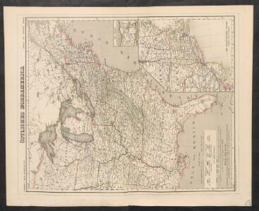
Vereinigten Staaten v. N. America.
1 : 5140000 Weiland, C. F. (Carl Ferdinand), d. 1847
Map of the United States : drawn from the most approved surveys.
from Whole
A map of the United States including Louisiana / by Wm. Darby ; engraved by Jas. D. Stout.
from Whole
A map of the United States : compiled chiefly from the state maps and other authentic information / by Saml. Lewis, 1809 ; W. [Harrison?] Junr., sculpt.
from Carey's American atlas.
United States of America / engrav'd by J. Warr Jr., No. 110 Walnut St. Philada.
from Whole J. Warr Jr.,
Map of the United States of North America / compiled from the latest and most authentic information by David H. Vance ; engraved by J.H. Young.
from Whole
United States

United States.
1 : 11800000 Darton, William
Vereinigten Staaten von Nord America
Neuester Schul-Atlas Walch, Johann im Verlag bei Joh. Walch
Etats-Unis, Canada, Floride.
1 : 13500000 Delamarche, Charles Francois; Lattre, Jean
A Map of Carolana and of the River Meschacebe &c.
from Charts and maps Printed for B. Cowse?: [London],
United States of America.
1 : 7900000 Lavoisne, M.
United States of America.
1 : 7900000 Lavoisne, M.
Amplissimae regionis Mississipi seu Provinciae Ludovicianae â R. P. Ludovico Hennepin francisc miss. in America septentrionali anno 1687 detectae, nunc Gallorum coloniis et actionum negotiis toto orbe celeberrimae, nova tabula
1 : 6350000 Mississippi, řeka-oblast Homann, Johann Baptist a Io. Bapt. Homanno
Carte Militaire des Etats - Unis (Partie Orientale).
1 : 5800000 Jouvet et Cie.
Map Of The United States
1 : 2300000 Vance, David H.
United States / by David H. Burr; engraved by S. Stiles & Co., N. York.
from Whole David H. Burr; S. Stiles & Co.,
Canada, Le Colonie Inglesi Con La Luigiana, e Florida.
1 : 10000000 Zatta, Antonio
4. Population 1830-1860.
1 : 8450000 Gannett, Henry, 1846-1914; United States. Census Office
3. Population 1790-1820.
1 : 8450000 Gannett, Henry, 1846-1914; United States. Census Office
Foreign population 1870.
1 : 7200000 Walker, Francis Amasa, 1840-1897
US Population 1850.
1 : 7100000 Walker, Francis Amasa, 1840-1897
Illiteracy 1870.
1 : 7100000 Walker, Francis Amasa, 1840-1897
Enteric, cerebro-spinal, typhus deaths.
1 : 7200000 Walker, Francis Amasa, 1840-1897
Foreign parentage 1870.
1 : 7100000 Walker, Francis Amasa, 1840-1897
Colored population proportion 1870.
1 : 7100000 Walker, Francis Amasa, 1840-1897
White male illiteracy.
1 : 7100000 Walker, Francis Amasa, 1840-1897
Predominating sex US.
1 : 7200000 Walker, Francis Amasa, 1840-1897
US Population 1860.
1 : 7100000 Walker, Francis Amasa, 1840-1897
US Population 1790-1820.
1 : 14300000 Walker, Francis Amasa, 1840-1897
Public indebtedness US.
1 : 7200000 Walker, Francis Amasa, 1840-1897
Consumption deaths US.
1 : 7200000 Walker, Francis Amasa, 1840-1897
Intestinal diseases deaths US.
1 : 7200000 Walker, Francis Amasa, 1840-1897
Malarial deaths US.
1 : 7200000 Walker, Francis Amasa, 1840-1897
Taxation per capita US.
1 : 7200000 Walker, Francis Amasa, 1840-1897
Wealth distribution US.
1 : 7200000 Walker, Francis Amasa, 1840-1897
Foreign population proportion 1870.
1 : 7200000 Walker, Francis Amasa, 1840-1897
Irish, German population 1870.
1 : 14300000 Walker, Francis Amasa, 1840-1897
Foreign parentage proportion 1870.
1 : 7100000 Walker, Francis Amasa, 1840-1897
Farms, production, corn, dairy.
1 : 14300000 Walker, Francis Amasa, 1840-1897
Crops US.
1 : 14300000 Walker, Francis Amasa, 1840-1897
Birth rate US.
1 : 7200000 Walker, Francis Amasa, 1840-1897