Maps of Vraňany

Wraňan - c8802-1-001 - Kaiserpflichtexemplar der Landkarten des stabilen Katasters
1 : 2880
Wraňan - c8802-1-002 - Kaiserpflichtexemplar der Landkarten des stabilen Katasters
1 : 2880
Wraňan - c8802-1-003 - Kaiserpflichtexemplar der Landkarten des stabilen Katasters
1 : 2880
Wraňan - c8802-1-004 - Kaiserpflichtexemplar der Landkarten des stabilen Katasters
1 : 2880
Spomischel - c7180-1-001 - Kaiserpflichtexemplar der Landkarten des stabilen Katasters
1 : 2880
Spomischel - c7180-1-002 - Kaiserpflichtexemplar der Landkarten des stabilen Katasters
1 : 2880
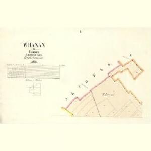
Jenowes - c2875-1-001 - Kaiserpflichtexemplar der Landkarten des stabilen Katasters
1 : 2880
Jenowes - c2875-1-003 - Kaiserpflichtexemplar der Landkarten des stabilen Katasters
1 : 2880
Jenowes - c2875-1-002 - Kaiserpflichtexemplar der Landkarten des stabilen Katasters
1 : 2880
Luschetz (Lužec) - c4329-1-004 - Kaiserpflichtexemplar der Landkarten des stabilen Katasters
1 : 2880
Luschetz (Lužec) - c4329-1-002 - Kaiserpflichtexemplar der Landkarten des stabilen Katasters
1 : 2880
Luschetz (Lužec) - c4329-1-005 - Kaiserpflichtexemplar der Landkarten des stabilen Katasters
1 : 2880
Luschetz (Lužec) - c4329-1-003 - Kaiserpflichtexemplar der Landkarten des stabilen Katasters
1 : 2880
Luschetz (Lužec) - c4329-1-001 - Kaiserpflichtexemplar der Landkarten des stabilen Katasters
1 : 2880
Mlczehost - c4755-1-003 - Kaiserpflichtexemplar der Landkarten des stabilen Katasters
1 : 2880
Mlczehost - c4755-1-001 - Kaiserpflichtexemplar der Landkarten des stabilen Katasters
1 : 2880
Mlczehost - c4755-1-002 - Kaiserpflichtexemplar der Landkarten des stabilen Katasters
1 : 2880
Krziwaus (Křiwaus) - c3660-1-004 - Kaiserpflichtexemplar der Landkarten des stabilen Katasters
1 : 2880
Krziwaus (Křiwaus) - c3660-1-002 - Kaiserpflichtexemplar der Landkarten des stabilen Katasters
1 : 2880
Krziwaus (Křiwaus) - c3660-1-001 - Kaiserpflichtexemplar der Landkarten des stabilen Katasters
1 : 2880
Krziwaus (Křiwaus) - c3660-1-003 - Kaiserpflichtexemplar der Landkarten des stabilen Katasters
1 : 2880
III. vojenské mapování 3853/3
1 : 25000
Gradkartenblatt
1 : 25000 Mělník-oblast (Česko) Albrecht, Julius
III. vojenské mapování 3853/3
1 : 25000
III. vojenské mapování 3853/3
1 : 25000
Okolí Mělníka a Kralup n. V
1 : 25000 Kralupy nad Vltavou-oblast (Česko) Nešvera, P. Plesinger, Václav P. Nešvera a V. Plesinger
Hydrografische Uibersichtskarte der Flüsse, Bäche und sonstigen Gewässer im Königreiche Boehmen


Podrobné mapy zemí Koruny české v měřítku 1:75.000 a mapa vzdáleností všech míst při silnici ležících
1 : 75000 Kostelec nad Labem (Česko : oblast) Bělohlav, Josef Kučera, Karel F. Topič