Maps of Mělnické Vtelno

Podrobné mapy zemí Koruny české v měřítku 1:75.000 a mapa vzdáleností všech míst při silnici ležících
1 : 75000 Kostelec nad Labem (Česko : oblast) Bělohlav, Josef Kučera, Karel F. Topič
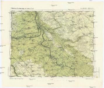
Podrobné mapy zemí Koruny české v měřítku 1:75.000 a mapa vzdáleností všech míst při silnici ležících - Mělník - Kostelec n. L. Průvodce statisticko-historický po všech místech na těchto mapách uvedených a rejstřík věcný názvů hor, potoků, řek, rybníků atd. Sešit 7. List 54,
1 : 75000
Mapa politického a školního okresu Mělnického
1 : 80000 Mělník-oblast (Česko) Vojna, Jan Hlaváček, Gustav Okresní školní výbor
Mapa okresu Mělnického
1 : 58000 Mělník-oblast (Česko) Opa, František Karel František Kar. Opa
Karte des Melniker Bezirkes im Prager Kreise
1 : 72000 Mělník-oblast (Česko) Wagner, Jan Eduard in Commission bei Karl André
Karte des Melniker Bezirkes im Prager Kreise
1 : 72000 Mělník-oblast (Česko) Wagner, Jan Eduard in Commission bei Karl André
Karte des Melniker Bezirkes im Prager Kreise
1 : 72000 Mělník-oblast (Česko) Wagner, Jan Eduard in Commission bei Karl André

III. vojenské mapování 3853/3
1 : 25000
III. vojenské mapování 3853/3
1 : 25000
III. vojenské mapování 3853/3
1 : 25000
Gradkartenblatt
1 : 25000 Mělník-oblast (Česko) Albrecht, Julius
Okolí Mělníka a Kralup n. V
1 : 25000 Kralupy nad Vltavou-oblast (Česko) Nešvera, P. Plesinger, Václav P. Nešvera a V. Plesinger
Plan der südlichen Gegend von Melnik
1 : 48000 Mělník-oblast (Česko) Schwihlik, Fr.
Mapa politického a školního okresu Karlínského
Hydrografische Uibersichtskarte der Flüsse, Bäche und sonstigen Gewässer im Königreiche Boehmen

Plan der Gegend zwischen Kletzan und Weltrus
1 : 47500 Klecany (Česko) Schwihlik, F.
Plan der Gegend zwischen Kletzan und Weltrus
1 : 48000 Klecany (Česko) Adam

III. vojenské mapování 3853/4
1 : 25000
III. vojenské mapování 3853/4
1 : 25000
III. vojenské mapování 3853/4
1 : 25000
Gradkartenblatt
1 : 25000 Benátky nad Jizerou-oblast (Česko) Albrecht, Julius
Lager bey Weldruss
1 : 62000 Veltrusy (Česko)
Plan von dem Laager bey Weldruss
1 : 31000 Veltrusy (Česko)
Czeczelitz - c0810-1-006 - Kaiserpflichtexemplar der Landkarten des stabilen Katasters
1 : 2880
Czeczelitz - c0810-1-004 - Kaiserpflichtexemplar der Landkarten des stabilen Katasters
1 : 2880
Czeczelitz - c0810-1-002 - Kaiserpflichtexemplar der Landkarten des stabilen Katasters
1 : 2880
Czeczelitz - c0810-1-003 - Kaiserpflichtexemplar der Landkarten des stabilen Katasters
1 : 2880
Czeczelitz - c0810-1-007 - Kaiserpflichtexemplar der Landkarten des stabilen Katasters
1 : 2880
Czeczelitz - c0810-1-001 - Kaiserpflichtexemplar der Landkarten des stabilen Katasters
1 : 2880