Maps of Obříství
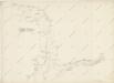
Hydrografische Uibersichtskarte der Flüsse, Bäche und sonstigen Gewässer im Königreiche Boehmen

Okolí Mělníka a Kralup n. V
1 : 25000 Kralupy nad Vltavou-oblast (Česko) Nešvera, P. Plesinger, Václav P. Nešvera a V. Plesinger
III. vojenské mapování 3853/3
1 : 25000
Gradkartenblatt
1 : 25000 Mělník-oblast (Česko) Albrecht, Julius
III. vojenské mapování 3853/3
1 : 25000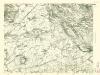
III. vojenské mapování 3853/3
1 : 25000
Lager bey Weldruss
1 : 62000 Veltrusy (Česko)
Plan von dem Laager bey Weldruss
1 : 31000 Veltrusy (Česko)
Cittow - c0765-1-001 - Kaiserpflichtexemplar der Landkarten des stabilen Katasters
1 : 2880
Cittow - c0765-1-006 - Kaiserpflichtexemplar der Landkarten des stabilen Katasters
1 : 2880
Cittow - c0765-1-004 - Kaiserpflichtexemplar der Landkarten des stabilen Katasters
1 : 2880
Cittow - c0765-1-007 - Kaiserpflichtexemplar der Landkarten des stabilen Katasters
1 : 2880
Cittow - c0765-1-005 - Kaiserpflichtexemplar der Landkarten des stabilen Katasters
1 : 2880
Cittow - c0765-1-003 - Kaiserpflichtexemplar der Landkarten des stabilen Katasters
1 : 2880
Cittow - c0765-1-002 - Kaiserpflichtexemplar der Landkarten des stabilen Katasters
1 : 2880
Plan der gegend des Furst von Lobkowitzischen Lust Schlosses Horzin bei Melnik

Kostomlat - c3391-1-004 - Kaiserpflichtexemplar der Landkarten des stabilen Katasters
1 : 2880
Kostomlat - c3391-1-001 - Kaiserpflichtexemplar der Landkarten des stabilen Katasters
1 : 2880
Kostomlat - c3391-1-003 - Kaiserpflichtexemplar der Landkarten des stabilen Katasters
1 : 2880
Kostomlat - c3391-1-002 - Kaiserpflichtexemplar der Landkarten des stabilen Katasters
1 : 2880
Kostomlat - c3391-1-005 - Kaiserpflichtexemplar der Landkarten des stabilen Katasters
1 : 2880
Weltrus - c8474-1-003 - Kaiserpflichtexemplar der Landkarten des stabilen Katasters
1 : 2880
Weltrus - c8474-1-005 - Kaiserpflichtexemplar der Landkarten des stabilen Katasters
1 : 2880
Weltrus - c8474-1-004 - Kaiserpflichtexemplar der Landkarten des stabilen Katasters
1 : 2880
Weltrus - c8474-1-002 - Kaiserpflichtexemplar der Landkarten des stabilen Katasters
1 : 2880
Weltrus - c8474-1-001 - Kaiserpflichtexemplar der Landkarten des stabilen Katasters
1 : 2880
Obřistwj - c5363-1-006 - Kaiserpflichtexemplar der Landkarten des stabilen Katasters
1 : 2880
Obřistwj - c5363-1-004 - Kaiserpflichtexemplar der Landkarten des stabilen Katasters
1 : 2880
Obřistwj - c5363-1-005 - Kaiserpflichtexemplar der Landkarten des stabilen Katasters
1 : 2880
Obřistwj - c5363-1-003 - Kaiserpflichtexemplar der Landkarten des stabilen Katasters
1 : 2880
Obřistwj - c5363-1-001 - Kaiserpflichtexemplar der Landkarten des stabilen Katasters
1 : 2880


