Maps of Vojkovice

Wogkowitz (Wogkowice) - c8733-1-002 - Kaiserpflichtexemplar der Landkarten des stabilen Katasters
1 : 2880
Wogkowitz (Wogkowice) - c8733-1-001 - Kaiserpflichtexemplar der Landkarten des stabilen Katasters
1 : 2880
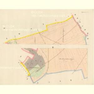
Krziwaus (Křiwaus) - c3660-1-004 - Kaiserpflichtexemplar der Landkarten des stabilen Katasters
1 : 2880
Krziwaus (Křiwaus) - c3660-1-002 - Kaiserpflichtexemplar der Landkarten des stabilen Katasters
1 : 2880
Krziwaus (Křiwaus) - c3660-1-001 - Kaiserpflichtexemplar der Landkarten des stabilen Katasters
1 : 2880
Krziwaus (Křiwaus) - c3660-1-003 - Kaiserpflichtexemplar der Landkarten des stabilen Katasters
1 : 2880
Hostin - c2246-1-002 - Kaiserpflichtexemplar der Landkarten des stabilen Katasters
1 : 2880
Hostin - c2246-1-003 - Kaiserpflichtexemplar der Landkarten des stabilen Katasters
1 : 2880
Hostin - c2246-1-001 - Kaiserpflichtexemplar der Landkarten des stabilen Katasters
1 : 2880
Wschestud - c8909-1-001 - Kaiserpflichtexemplar der Landkarten des stabilen Katasters
1 : 2880
Wschestud - c8909-1-002 - Kaiserpflichtexemplar der Landkarten des stabilen Katasters
1 : 2880
Wschestud - c8909-1-003 - Kaiserpflichtexemplar der Landkarten des stabilen Katasters
1 : 2880
Drzinow - c1570-1-002 - Kaiserpflichtexemplar der Landkarten des stabilen Katasters
1 : 2880
Drzinow - c1570-1-001 - Kaiserpflichtexemplar der Landkarten des stabilen Katasters
1 : 2880
Drzinow - c1570-1-003 - Kaiserpflichtexemplar der Landkarten des stabilen Katasters
1 : 2880
Lager bey Weldruss
1 : 62000 Veltrusy (Česko)
Plan von dem Laager bey Weldruss
1 : 31000 Veltrusy (Česko)
III. vojenské mapování 3853/3
1 : 25000
Gradkartenblatt
1 : 25000 Mělník-oblast (Česko) Albrecht, Julius
III. vojenské mapování 3853/3
1 : 25000
III. vojenské mapování 3853/3
1 : 25000
Okolí Mělníka a Kralup n. V
1 : 25000 Kralupy nad Vltavou-oblast (Česko) Nešvera, P. Plesinger, Václav P. Nešvera a V. Plesinger
Karte des Welwarner Bezirkes im Prager Kreise
1 : 72400 Velvary-oblast (Česko) Wagner, Jan Eduard Karl André
Karte des Welwarner Bezirkes im Prager Kreise
1 : 72400 Velvary-oblast (Česko) Wagner, Jan Eduard Karl André
Hydrografische Uibersichtskarte der Flüsse, Bäche und sonstigen Gewässer im Königreiche Boehmen

Plan der Gegend zwischen Kletzan und Weltrus
1 : 47500 Klecany (Česko) Schwihlik, F.
Plan der Gegend zwischen Kletzan und Weltrus
1 : 48000 Klecany (Česko) Adam

Podrobné mapy zemí Koruny české v měřítku 1:75.000 a mapa vzdáleností všech míst při silnici ležících
1 : 75000 Kostelec nad Labem (Česko : oblast) Bělohlav, Josef Kučera, Karel F. Topič