Maps of Odolena Voda

Kopetsch - c3329-1-002 - Kaiserpflichtexemplar der Landkarten des stabilen Katasters
1 : 2880
Kopetsch - c3329-1-001 - Kaiserpflichtexemplar der Landkarten des stabilen Katasters
1 : 2880
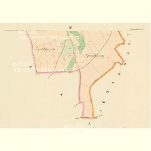
Wodolka - c5372-1-003 - Kaiserpflichtexemplar der Landkarten des stabilen Katasters
1 : 2880
Wodolka - c5372-1-001 - Kaiserpflichtexemplar der Landkarten des stabilen Katasters
1 : 2880
Wodolka - c5372-1-002 - Kaiserpflichtexemplar der Landkarten des stabilen Katasters
1 : 2880
Wodolka - c5372-1-004 - Kaiserpflichtexemplar der Landkarten des stabilen Katasters
1 : 2880
Netrzeb (Netřeb) - c5077-1-001 - Kaiserpflichtexemplar der Landkarten des stabilen Katasters
1 : 2880
Netrzeb (Netřeb) - c5077-1-002 - Kaiserpflichtexemplar der Landkarten des stabilen Katasters
1 : 2880
Grossdorf (Welka-Wes) - c8376-1-003 - Kaiserpflichtexemplar der Landkarten des stabilen Katasters
1 : 2880
Grossdorf (Welka-Wes) - c8376-1-004 - Kaiserpflichtexemplar der Landkarten des stabilen Katasters
1 : 2880
Grossdorf (Welka-Wes) - c8376-1-001 - Kaiserpflichtexemplar der Landkarten des stabilen Katasters
1 : 2880
Grossdorf (Welka-Wes) - c8376-1-002 - Kaiserpflichtexemplar der Landkarten des stabilen Katasters
1 : 2880
Mapa politického a školního okresu Karlínského

Okolí Mělníka a Kralup n. V
1 : 25000 Kralupy nad Vltavou-oblast (Česko) Nešvera, P. Plesinger, Václav P. Nešvera a V. Plesinger
Plan der Gegend zwischen Kletzan und Weltrus
1 : 47500 Klecany (Česko) Schwihlik, F.
Plan der Gegend zwischen Kletzan und Weltrus
1 : 48000 Klecany (Česko) Adam


Podrobné mapy zemí Koruny české v měřítku 1:75.000 a mapa vzdáleností všech míst při silnici ležících
1 : 75000 Kostelec nad Labem (Česko : oblast) Bělohlav, Josef Kučera, Karel F. Topič
Podrobné mapy zemí Koruny české v měřítku 1:75.000 a mapa vzdáleností všech míst při silnici ležících - Mělník - Kostelec n. L. Průvodce statisticko-historický po všech místech na těchto mapách uvedených a rejstřík věcný názvů hor, potoků, řek, rybníků atd. Sešit 7. List 54,
1 : 75000
Schema des Moldau - Flusses von Prag bis Melnik

Soubor map okresů Pražského kraje

Mapa politického a školního okresu Mělnického
1 : 80000 Mělník-oblast (Česko) Vojna, Jan Hlaváček, Gustav Okresní školní výbor
Brandýský vikariát
Brandýs nad Labem-Stará Boleslav-oblast (Česko)
Mělník
1 : 75000 Mělník (Česko : oblast) Vojenský zeměpisný ústav
Verbindungs-Dreiecke der Grundlinie zwischen dem Lorenz- und Georgenberge mit der trigonometrischen Vermessung der Gegend um Neuschloss
Petřín (Praha, Česko)
Velvary a okolí
1 : 75000 Velvary (Česko : oblast) Vojenský zeměpisný ústav
Uibersichtskarte der Moldau von Stěchovic uiber Prag bis unterhalb Mělnik

Eisenbahn Karte Wien-Dresden, Ollmütz-Trübau
1 : 72000 Blatt 14 Minarzik, Anselm J. Rauh