Maps of Prague

Soubor map okresů Pražského kraje

Podrobná mapa okolí Pražského List II.

Podrobná mapa okolí Pražského
1 : 75000 Brandýs nad Labem-Stará Boleslav (Česko : oblast) Hevera, Čeněk Klub československých turistů
Podrobná mapa okolí Pražského
1 : 75000 Brandýs nad Labem-Stará Boleslav (Česko : oblast) Hevera, Čeněk Klub československých turistů
Praha
1 : 75000 Praha (Česko : oblast) Vojenský zeměpisný ústav
Prag Zone 5, Kol. 11
1 : 75000
III. vojenské mapování 3953
1 : 75000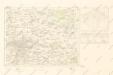
Mapy plánování ČSR
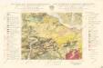
Geologická mapa Československé republiky, list Praha 3953

Prag
1 : 75000 Praha (Česko : oblast) Fitz, J. K. u. k. Militärgeographisches Institut
Prag
1 : 75000 Praha (Česko : oblast) K. u. k. Militärgeographisches Institut
Spezialkarte der Umgebung von Prag

[Prag und Umgebung]
1 : 57600 Praha (Česko) Carl Bellmann's Verlag
Podrobné mapy zemí koruny české v měřítku 1:75 000 a průvodce statisticko-historický po všech místech na těchto mapách uvedených. - Praha-Brandýs n. L. List 55
1 : 75000
Podrobné mapy zemí Koruny české v měřítku 1:75.000 - Praha - Brandýs n. L. Průvodce statisticko-historický po všech místech na těchto mapách uvedených a rejstřík věcný názvů hor, potoků, řek, rybníků atd. a mapa vzdáleností všech míst při silnici ležících Sešit 1. List 55,
1 : 75000
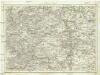
Karte des Karolinenthaler Bezirkes im Prager Kreise
1 : 72000 Karlín (Praha, Česko) Wagner, Jan Eduard in Commission bei Karl André
Karte des Karolinenthaler Bezirkes im Prager Kreise
1 : 72000 Karlín (Praha, Česko) Wagner, Jan Eduard Karl André
Karte des Karolinenthaler Bezirkes im Prager Kreise
1 : 72000 Karlín (Praha, Česko) Wagner, Jan Eduard in Commission bei Karl André
Karte des Karolinenthaler Bezirkes im Prager Kreise
1 : 72000 Karlín (Praha, Česko) Wagner, Jan Eduard in Commission bei Karl André
Karte des Karolinenthaler Bezirkes im Prager Kreise
1 : 72000 Karlín (Praha, Česko) Wagner, Jan Eduard in Commission bei Karl André
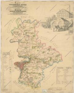
Velká Praha a okolí

[Umgebungen der königl. Hauptstadt Prag]
1 : 45000 Praha-oblast (Česko) Basdar
Podrobné mapy zemí Koruny české v měřítku 1:75.000 a mapa vzdáleností všech míst při silnici ležících
1 : 75000 Brandýs nad Labem-Stará Boleslav (Česko : oblast) Bělohlav, Josef F. Topič
Eisenbahn Karte Wien-Dresden, Ollmütz-Trübau
1 : 72000 Blatt 13 Minarzik, Anselm J. Rauh
Přesná nivelace Velké Prahy s okolím : [přehled nivelačních tratí a osazených výškových bodů]
1 : 25000
Praha - městská hromadná doprava
1 : 40000
Umgebung der königl. Hauptstadt Prag
Praha-oblast (Česko) Heber, Franz Alexander Berra, Marco Marco Berra
Praha a okolí
Praha (Česko : oblast) Kuchař, Karel
Plan der koniglichen Hauptstadt Prag mit den naechsten Umgebungen
Praha-oblast (Česko) Kral, Anton