Maps of Hořín

Brozanek - c0531-1-001 - Kaiserpflichtexemplar der Landkarten des stabilen Katasters
1 : 2880
Brozanek - c0531-1-002 - Kaiserpflichtexemplar der Landkarten des stabilen Katasters
1 : 2880
Schopka - c6271-1-001 - Kaiserpflichtexemplar der Landkarten des stabilen Katasters
1 : 2880
Melnik (Mělník)
Plan der gegend des Furst von Lobkowitzischen Lust Schlosses Horzin bei Melnik

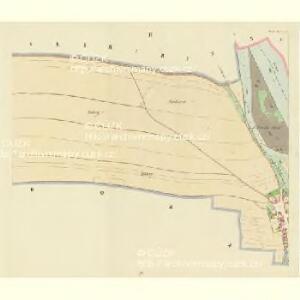
Horzin - c2232-1-004 - Kaiserpflichtexemplar der Landkarten des stabilen Katasters
1 : 2880
Horzin - c2232-1-002 - Kaiserpflichtexemplar der Landkarten des stabilen Katasters
1 : 2880
Horzin - c2232-1-003 - Kaiserpflichtexemplar der Landkarten des stabilen Katasters
1 : 2880
Horzin - c2232-1-001 - Kaiserpflichtexemplar der Landkarten des stabilen Katasters
1 : 2880
Begkew - c0698-1-002 - Kaiserpflichtexemplar der Landkarten des stabilen Katasters
1 : 2880
Begkew - c0698-1-003 - Kaiserpflichtexemplar der Landkarten des stabilen Katasters
1 : 2880
Begkew - c0698-1-001 - Kaiserpflichtexemplar der Landkarten des stabilen Katasters
1 : 2880
Bez titulu: Plán Mělníka
III. vojenské mapování 3853/3
1 : 25000
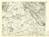
Gradkartenblatt
1 : 25000 Mělník-oblast (Česko) Albrecht, Julius
Plan der südlichen Gegend von Melnik
1 : 48000 Mělník-oblast (Česko) Schwihlik, Fr.
III. vojenské mapování 3853/3
1 : 25000
III. vojenské mapování 3853/3
1 : 25000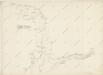
Hydrografische Uibersichtskarte der Flüsse, Bäche und sonstigen Gewässer im Königreiche Boehmen


Podrobné mapy zemí Koruny české v měřítku 1:75.000 a mapa vzdáleností všech míst při silnici ležících
1 : 75000 Kostelec nad Labem (Česko : oblast) Bělohlav, Josef Kučera, Karel F. Topič
Podrobné mapy zemí Koruny české v měřítku 1:75.000 a mapa vzdáleností všech míst při silnici ležících - Mělník - Kostelec n. L. Průvodce statisticko-historický po všech místech na těchto mapách uvedených a rejstřík věcný názvů hor, potoků, řek, rybníků atd. Sešit 7. List 54,
1 : 75000
Mapa okresu Mělnického
1 : 58000 Mělník-oblast (Česko) Opa, František Karel František Kar. Opa
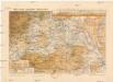
Karte des Melniker Bezirkes im Prager Kreise
1 : 72000 Mělník-oblast (Česko) Wagner, Jan Eduard in Commission bei Karl André
Karte des Melniker Bezirkes im Prager Kreise
1 : 72000 Mělník-oblast (Česko) Wagner, Jan Eduard in Commission bei Karl André
Karte des Melniker Bezirkes im Prager Kreise
1 : 72000 Mělník-oblast (Česko) Wagner, Jan Eduard in Commission bei Karl André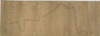
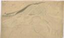
Schema des Moldau - Flusses von Prag bis Melnik

Mapa politického a školního okresu Mělnického
1 : 80000 Mělník-oblast (Česko) Vojna, Jan Hlaváček, Gustav Okresní školní výbor