Maps of Germany

Reisekarte von Deutschland und den angrenzenden Ländern
Evropa střední Mahlmann, H. Morin, F. H. F.H. Morin
Post und Reisekartre von Deutschland...

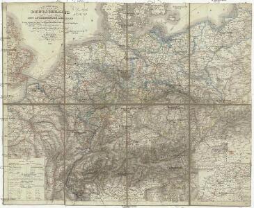
Post- und Reise-Karte von Deutschland und den anliegenden Laendern bis London, Havre de Grace, Tours, Lyon, Genua, Bologna, Pest, Warschau, Königsberg u. jenseits Kopenhagen, nebst den Haupt-Routen durch das übrige Europa
1 : 1490000 Belgie Diez, F. M. Perthes, Justus Justus Perthes
Post- und Reise-Karte von Deutschland und den anliegenden Ländern bis London, Havre de Grace, Tours, Lyon, Genua, Bologna, Pest, Warschau, Königsberg u. jenseits Kopenhagen, nebst den haupt Routen durch das übrige Europa
1 : 1490000 Belgie Diez, F. M. Justus Perthes
Post- und Eisenbahnkarte von Deutschland und den benachbarten Laendern
1 : 2450000 Evropa střední Weiland, Karl Ferdinand Mädel, C. J. Geograph. Institut
Verbreitung der wichtigsten Kulturgewächse
Evropa střední F.A. Brockhaus Geogr. artist. Anstalt
Post- und Reise-Charte von Deutschland und den benachbarten Laendern / nach den neuesten Quellen entw. von C.F. Weiland ; C.J. Maedel sculps.
1 : 1500000 Annotatie geografische gegevens: Grenzen gekleurd Weiland, C. F.; Maedel, C. J. Weimar : Geogr. Institut
Post- und Reisekarte von Deutschland, den Niederlanden, Belgien und der Schweiz, nebst Theilen der angrenzenden Länder bis London, Havre de Grace, Turin, Warschau, Kopenhagen
1 : 2500000 Bachmann, Fr. Verlag der Friedrich Kornschen Buchhandlung
Imperium Romano-Germanicum
1 : 2600000 Mollova mapová sbírka Seutter, Matthäus Seutter, Matthäus
Reise - Karte von Deutschland und den Nachbarstaaten

Deutschland, Ubersicht Des Deutschen Reichs.
1 : 3700000 Berghaus, Hermann
Deutschland Und Benachbarte Lander. Zur Ubersicht Der Eisenbahnen Und Dampfschiffahrten.
1 : 3700000 Vogel, C.
L'Allemagne.
1 : 2500000 L'Isle, Guillaume de, 1675-1726
L'Allemagne.
1 : 2500000 L'Isle, Guillaume de, 1675-1726
Übersicht der Schnellpost und Eilwagen, ... Deutschland

Imperium Romano-Germanicum in suos circulos electorat. et status
1 : 2700000 Evropa střední Seutter, Matthäus apud Matth. Seutter
Imperium Romano-Germanicum in suos circulos electorat. et status
1 : 2700000 Evropa střední Seutter, Matthäus Matth. Seutter
Imperium Romano-Germanicum in suos circulos electorat. et status
1 : 2700000 Evropa střední Seutter, Matthäus Matth. Seutter
Altgermanien, Sud-Donau-Lander, Mitte des Vten jahrhundert's.
1 : 3800000 Spruner von Merz, Karl
Mappa Geographica exhibens Postas

Tabula Germaniae
1 : 2780000 Evropa střední Visscher, Claes Jansz. Broeck, Abraham van den Claes Ianßen Visscher excudebat
Mitteleuropa Übersicht der politischen Verhältnisse und Hauptverkehrswege
1 : 5000000 Mitteleuropa Verkehrsnetz
Post- und Reisekarte von Deutschland, den Niederlanden, Belgien und der Schweiz
1 : 2470000 Belgie Bachmann, Friedrich Nast Friedr. Kornschen Buchhandlung
Post- und Reisekarte von Deutschland, den Niederlanden, Belgien und der Schweiz
1 : 2470000 Belgie Bachmann, Friedrich Nast Friedr. Kornschen Buchhandlung
L'Allemagne
1 : 2500000 L'Isle, Guillaume de Dezauche
Imperium Romano-Germanicum
1 : 2600000 Mollova mapová sbírka Seutter, Matthäus Seutter, Matthäus
Deutschland physikalisch.
1 : 3400000 Andree, Richard
Mitteleuropa Übersicht der Bodenverhältnisse
1 : 5000000 Mitteleuropa
Eisenbahn-Karte von Mittel-Europa
1 : 8200000 Evropa střední