Maps of Germany

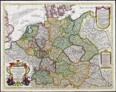
L'Allemagne
1 : 2500000 L'Isle, Guillaume de Dezauche
GERMANIA
1 : 2500000 Evropa střední Delisle, Guillaume Lotter, Georg F. Tobiae Conradi Lotter
Germania
1 : 2500000 Evropa střední Delisle, Guillaume Lotter, Georg F. T. C. Lotter
Germania
1 : 2500000 Evropa střední Delisle, Guillaume Brahe, Tycho Tobiae Conradi Lotter
Germania
1 : 2500000 Evropa střední Delisle, Guillaume Brahe, Tycho in officina Tobiae Conradi Lotter
Germania
1 : 2500000 Evropa střední Delisle, Guillaume Brahe, Tycho in officina Tobiae Conradi Lotter
Germania
1 : 2500000 Evropa střední Delisle, Guillaume Brahe, Tycho in officina Tobiae Conradi Lotter
Germania
1 : 2500000 Německo Delisle, Guillaume Lotter, Georg F. T. C. Lotter
Post- und Eisenbahnkarte von Deutschland und den benachbarten Laendern
1 : 2450000 Evropa střední Weiland, Karl Ferdinand Mädel, C. J. Geograph. Institut
Post- und Reise-Karte von Deutschland und den anliegenden Laendern bis London, Havre de Grace, Tours, Lyon, Genua, Bologna, Pest, Warschau, Königsberg u. jenseits Kopenhagen, nebst den Haupt-Routen durch das übrige Europa
1 : 1490000 Belgie Diez, F. M. Perthes, Justus Justus Perthes
Post- und Reise-Karte von Deutschland und den anliegenden Ländern bis London, Havre de Grace, Tours, Lyon, Genua, Bologna, Pest, Warschau, Königsberg u. jenseits Kopenhagen, nebst den haupt Routen durch das übrige Europa
1 : 1490000 Belgie Diez, F. M. Justus Perthes
Post- und Reisekarte von Deutschland, den Niederlanden, Belgien und der Schweiz
1 : 2470000 Belgie Bachmann, Friedrich Nast Friedr. Kornschen Buchhandlung
Post- und Reisekarte von Deutschland, den Niederlanden, Belgien und der Schweiz
1 : 2470000 Belgie Bachmann, Friedrich Nast Friedr. Kornschen Buchhandlung
Reisekarte von Deutschland und den angrenzenden Ländern
Evropa střední Mahlmann, H. Morin, F. H. F.H. Morin
Altgermanien, Sud-Donau-Lander, Mitte des Vten jahrhundert's.
1 : 3800000 Spruner von Merz, Karl
Nieuwe kaart van Duitschland, opgemaakt volgens de naukeurigste waarneemingen
1 : 7250000 [S.l.] : [s.n.]
Germania
1 : 2500000 Mollova mapová sbírka Delisle, Guillaume Seutter, Matthäus Wolff, Jeremias
L'Allemagne
1 : 2600000 Mollova mapová sbírka Delisle, Guillaume Liébaux, Jean-Baptiste L'Isle, Guillaume de
L'Allemagne
1 : 2500000 Mollova mapová sbírka Delisle, Guillaume Covens, Johannes I
Post und Reisekartre von Deutschland...

Post- und Reisekarte von Deutschland, den Niederlanden, Belgien und der Schweiz, nebst Theilen der angrenzenden Länder bis London, Havre de Grace, Turin, Warschau, Kopenhagen
1 : 2500000 Bachmann, Fr. Verlag der Friedrich Kornschen Buchhandlung
L'Allemagne.
1 : 2500000 L'Isle, Guillaume de, 1675-1726
L'Allemagne.
1 : 2500000 L'Isle, Guillaume de, 1675-1726
Mappa Geographica exhibens Postas

Tabula Germaniae emendata recens [Karte], in: Novus atlas absolutissimus, Bd. 2, S. 16.
1 Karte aus Atlas Janssonius Offizin
Imperium Romano-Germanicum
1 : 2600000 Mollova mapová sbírka Seutter, Matthäus Seutter, Matthäus
Übersicht der Schnellpost und Eilwagen, ... Deutschland

Tabula Germaniae
1 : 2780000 Evropa střední Visscher, Claes Jansz. Broeck, Abraham van den Claes Ianßen Visscher excudebat
Nova Totius Germaniae Descriptio. [Karte], in: Le théâtre du monde, ou, Nouvel atlas contenant les chartes et descriptions de tous les païs de la terre, Bd. 1, S. 102.
1 Karte aus Atlas Blaeu, Willem Janszoon und Blaeu, Joan Blaeu, Willem Janszoon