Maps of Germany

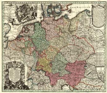
Imperium Romano-Germanicum
1 : 2600000 Mollova mapová sbírka Seutter, Matthäus Seutter, Matthäus
Post- und Reisekarte von Deutschland, den Niederlanden, Belgien und der Schweiz, nebst Theilen der angrenzenden Länder bis London, Havre de Grace, Turin, Warschau, Kopenhagen
1 : 2500000 Bachmann, Fr. Verlag der Friedrich Kornschen Buchhandlung
Post und Reisekartre von Deutschland...

Post- und Eisenbahnkarte von Deutschland und den benachbarten Laendern
1 : 2450000 Evropa střední Weiland, Karl Ferdinand Mädel, C. J. Geograph. Institut
Post- und Reise-Karte von Deutschland und den anliegenden Laendern bis London, Havre de Grace, Tours, Lyon, Genua, Bologna, Pest, Warschau, Königsberg u. jenseits Kopenhagen, nebst den Haupt-Routen durch das übrige Europa
1 : 1490000 Belgie Diez, F. M. Perthes, Justus Justus Perthes
Post- und Reise-Karte von Deutschland und den anliegenden Ländern bis London, Havre de Grace, Tours, Lyon, Genua, Bologna, Pest, Warschau, Königsberg u. jenseits Kopenhagen, nebst den haupt Routen durch das übrige Europa
1 : 1490000 Belgie Diez, F. M. Justus Perthes
Eisenbahn-Karte von Mittel-Europa
1 : 8200000 Evropa střední
Mappa Geographica exhibens Postas
Germany.
1 : 2400000 Robert Laurie & James Whittle
Verbreitung der wichtigsten Kulturgewächse
Evropa střední F.A. Brockhaus Geogr. artist. Anstalt
Imperium Romano-Germanicum
1 : 2600000 Mollova mapová sbírka Seutter, Matthäus Seutter, Matthäus
Reisekarte von Deutschland und den angrenzenden Ländern
Evropa střední Mahlmann, H. Morin, F. H. F.H. Morin
Übersicht der Schnellpost und Eilwagen, ... Deutschland
Prof. W. Liebenow's Kriegskarte von Mitteleuropa

Post- und Reise-Charte von Deutschland und den benachbarten Laendern / nach den neuesten Quellen entw. von C.F. Weiland ; C.J. Maedel sculps.
1 : 1500000 Annotatie geografische gegevens: Grenzen gekleurd Weiland, C. F.; Maedel, C. J. Weimar : Geogr. Institut

Neueste Eisenbahn-Karte von Deutschland und den angrenzenden Ländern
Evropa střední Walseck, Georg Georg Walseck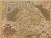
Germania. [Karte], in: Theatrum orbis terrarum, S. 40.
1 Karte aus Atlas Ortelius, Abraham
Imperium Romano-Germanicum in suos circulos electorat. et status
1 : 2700000 Evropa střední Seutter, Matthäus apud Matth. Seutter
Imperium Romano-Germanicum in suos circulos electorat. et status
1 : 2700000 Evropa střední Seutter, Matthäus Matth. Seutter
Imperium Romano-Germanicum in suos circulos electorat. et status
1 : 2700000 Evropa střední Seutter, Matthäus Matth. Seutter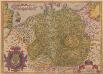
Germania. [Karte], in: Theatrum orbis terrarum, S. 102.
1 Karte aus Atlas Ortelius, Abraham
Germania, V. Nova Tabula. [Karte], in: Claud. Ptolemaeus. Geographia lat. cum mappis [...], S. 347.
1 Karte aus Atlas Münster, Sebastian [und Ptolemaeus, Claudius]
Tabula Germaniae
1 : 2780000 Evropa střední Visscher, Claes Jansz. Broeck, Abraham van den Claes Ianßen Visscher excudebat
Altgermanien, Sud-Donau-Lander, Mitte des Vten jahrhundert's.
1 : 3800000 Spruner von Merz, Karl
L' Empire D'Allemagne [...] [Karte], in: Atlas nouveau, contenant toutes les parties du monde [...], Bd. 1, S. 161.
1 Karte aus Atlas Sanson, Nicolas Jaillot, Alexis Hubert und Mortier, Pieter
Post- und Reisekarte von Deutschland, den Niederlanden, Belgien und der Schweiz
1 : 2470000 Belgie Bachmann, Friedrich Nast Friedr. Kornschen Buchhandlung
Post- und Reisekarte von Deutschland, den Niederlanden, Belgien und der Schweiz
1 : 2470000 Belgie Bachmann, Friedrich Nast Friedr. Kornschen Buchhandlung
Special-Karte der Eisenbahn- Post- u[nd] Dampfschiff-Verbindungen Mittel-Europa's
1 : 1240000 Evropa střední Raab, Christian Johann Carl Koch, A. C. Flemming