Maps of Sicilia
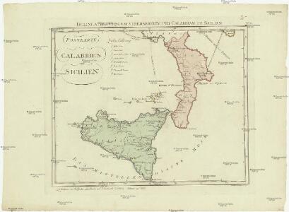
Postkarte von Calabrien und Sicilien
Kalábrie (Itálie) Benedict, Anton im von Reillyschen Landkarten und Kunstwerke Verschleiss Komptoir
Carta d'Italia alla scala di 1 a 1 000 000
1 : 1000000 Südost-Blatt Istituto Geografico Militare (Firenze) Istituto Geografico Militare
Fo. 6, uit: Carta geologica d'Italia
1 : 1000000 Rome : R. Ufficio Geologico
Roy. de Naples sud, Malte.
1 : 950000 Robert de Vaugondy, Gilles, 1688-1766

Königreich beider Sicilien nebst Südlichen Theile des Kirchenstaats / [Adolf Stieler]
1 : 1850000 Annotatie: Met administratieve indeling Gotha : Justus Perthes
Südliches Italien enthält Neapel und Sicilien nebst dem südlichen Theile des Kirchenstaates
Hand-Atlas über alle Theile der Erde nach dem neuesten Zustande und über das Weltgebäude Stieler, Adolf bei Justus Perthes
A series of maps, modern and ancient. No. 7 : Ancient Italy part III. and Sicily
1 : 1700000 under the superintendence of the Society for the Diffusion of Useful Knowledge J. & C. Walker London : Baldwin and Cradock
Italy 3.
1 : 1774080 Letts, Son & Co.
A series of maps, modern and ancient. No. 7 : Italy III
1 : 1700000 under the superintendence of the Society for the Diffusion of Useful Knowledge J. & C. Walker London : Baldwin and Cradock
[Italien, Blatt 4]
Adolf Stieler's Handatlas über alle Theile der Erde und über das Weltgebäude Stieler, Adolf Justus Perthes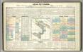
Tableau l'historie du Royaume de Naples et de Sicile.
1 : 4300000 Duval, Henri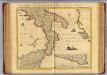
Naples et Sicile.
1 : 1240000 Covens et Mortier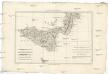
Partie méridionale du royaume de Naples et celui de l'isle de Sicile
1 : 1770000 Neapol-oblast (Itálie) Bonne, Rigobert André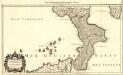
Le Royaume de Naples
1 : 1100000 Mollova mapová sbírka Nolin, Jean-Baptiste Jaillot, Alexis Hubert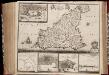
Insula sive regnum Siciliæ / urbibus præcipuis exornatum et novissime editum per F. de Wit
1 : 980000 Annotatie: Opdracht in cartouche rechtsonder op kaart: Amplißimo doctißimoque viro domino D.o Joanni Uytenbogaert J.cto nomine illustrium et præpotent. DD. ordinum Hollandiæ et Westvrisiæ Ærary Publici Amstelodamensis tribuno hanc tabulam D.C.Q. F. de Wit; Rechtsboven genummerd: 24; Origineel is Blad 166 in atlas factice; Annotatie geografische gegevens: Schaalstok [0] - 5 milliaria Germanica communia (= 3,8 cm); Noordoost boven Amsterdam : by Frederick de Wit inde Kalverstraet by den Dam inde Witte Paskaert
Regnum Siciliae Cum circumjacentibus Regnis et Insulis Nuperrime
1 : 1400000 Mollova mapová sbírka Visscher, Nicolaes Jansz. Schenk, Peter I
Neapolitani regni tabula
1 : 5050000 Neapol-oblast (Itálie)
Siciliae Veteris Typus. [Karte] [Syracusae und Umgebung] [Nebenkarte], in: Theatrum orbis terrarum, S. 502.
1 Karte aus Atlas Ortelius, Abraham Vrients, Jan Baptista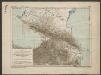
La Sicile divisée en ses trois Provinces ou Valées sçavoir Valle Di Demona, Valle Di Noto, Et Valle Di Mazara [Karte], in: Atlas nouveau, contenant toutes les parties du monde [...], Bd. 2, S. 146.
1 Karte aus Atlas Sanson, Nicolas Jaillot, Alexis Hubert und Mortier, Pieter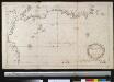
Een gedeelte of de Noord zijde vant eijland Sicilia in de Middellansche Zee
Italy Henri Michelot & Laurent Brémond Gerard van Keulen
Siciliae Veteris Typus. [Karte] [Syracusae] [Nebenkarte], in: Theatrum orbis terrarum, S. 401.
1 Karte aus Atlas Ortelius, Abraham
Insularum Aliquot Maris Mediterranei Descriptio. [Sicilia] [Karte], in: Theatrum orbis terrarum, S. 240.
1 Karte aus Atlas Ortelius, Abraham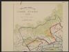
Siciliae Veteris Typus. [Karte], in: Gerardi Mercatoris et I. Hondii Newer Atlas, oder, Grosses Weltbuch, Bd. 2, S. 215.
1 Karte aus Atlas Mercator, Gerhard und Hondius, Jodocus Jansson, Jan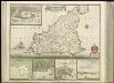
[33][33] Insula sive Regnum Siciliae ..., uit: Atlas sive Descriptio terrarum orbis
Annotatie: Gedigitaliseerde versie. Amsterdam. Heiloo : Picturae (vervaardiger), 2015. tiff-bestand. Gedigitaliseerd: 07-01-2015; Origineel: Universiteitsbibliotheek Vrije Universiteit (XL.05127.-) ; Netherlands; Titelpagina ontbreekt Wit, Frederik de Amsterdam : Frederick de Wit

Insularum Aliquot Maris Mediterranei Descriptio. [Sicilia] [Karte], in: Theatrum orbis terrarum, S. 335.
1 Karte aus Atlas Ortelius, Abraham Vrients, Jan Baptista
Insularum Aliquot Maris Mediterranei Descriptio. [Sicilia] [Karte], in: Theatrum orbis terrarum, S. 91.
1 Karte aus Atlas Ortelius, Abraham
Regnorvm Siciliae et Sardiniae nova & accurata Tabula proposita
1 : 970000 Mollova mapová sbírka Homann, Johann Baptist Homann, Johann Baptista