Maps of Apulia

Neapolitani regni tabula
1 : 5050000 Neapol-oblast (Itálie)
Charte von dem Königreiche Neapel
1 Karte : Kupferdruck ; 55 x 42 cm Götze im Verlage des Industrie Comptoirs
Sicily, Kingdom of Naples.
1 : 1000000 Robert Laurie & James Whittle


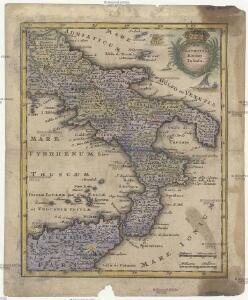
Neapolis Regnum, quo continentur Aprutium Ulterius et Citerius, Comitatus Molisius, Terra Laboris, Capitaniata, Principat. Ulterior et Citerior, Barianus et Hydruntinus Ager, Basilicata, Calabria Citerior et Ulterior
1 : 1000000 cura et caelo Tobiae Conradi Lotteri Augusta Vind : [T. C. Lotter]
Neapolis Regnum
1 : 1100000 Mollova mapová sbírka Seutter, Matthäus Seutter, Matthäus
[32][32] Regnum Neapolis ..., uit: Atlas sive Descriptio terrarum orbis
Annotatie: Gedigitaliseerde versie. Amsterdam. Heiloo : Picturae (vervaardiger), 2015. tiff-bestand. Gedigitaliseerd: 07-01-2015; Origineel: Universiteitsbibliotheek Vrije Universiteit (XL.05127.-) ; Netherlands; Titelpagina ontbreekt Wit, Frederik de Amsterdam : Frederick de Wit
Le Royaume de Naples Carte nouvelle Originale & Curieuse, nouvellement dresée Sur les memoires les plus recentes, accomondée a ce qui fait le théatre de la guerre aujourd'huy dans ce Royaume
1 : 1100000 Mollova mapová sbírka Briffaut, Etienne Briffaut, Stephan
Kingdom of Naples or The Two Sicilies.
1 : 2550000 Tanner, Henry S.
Kingdom of Naples or The Two Sicilies.
1 : 2500000 Tanner, Henry S.
Tableau l'historie du Royaume de Naples et de Sicile.
1 : 4300000 Duval, Henri
Regnum Neapolis Siciliae et Lipariae insulae multis locis correctae novissima descriptio
1 : 1100000 2 Karten auf 1 Blatt : Kupferdruck ; 54 x 47 cm und 14 x 17 cm, auf Blatt 62 x 53 cm Danckerts, Justus [Danckerts]
Carta del Regno di Napoli, indicante la divisione delle XIV sue provincie
1 : 750000 Rizzi Zannoni Vinc. Aloja ; Giov. Di Pietro scrisse. [Milano] : Buro Topografico della Guerra
Südliches Italien enthält Neapel und Sicilien nebst dem südlichen Theile des Kirchenstaates
Hand-Atlas über alle Theile der Erde nach dem neuesten Zustande und über das Weltgebäude Stieler, Adolf bei Justus Perthes
[Südliches Jtalien enthält Neapel und Sicilien]
Stieler's Hand-Atlas Stieler, Adolf bei Justus Perthes
Atlante del Regno di Napoli
1 : 420000
Regni Neapolitani Verissima Secvndvm Antiqvorvm Et Recentiorvm Traditionem Descriptio
1 : 1300000 Mollova mapová sbírka Ligorio, Pirro
REGNUM NEAPOLIS
1 : 1115000 Neapolsko (království) Wit, Frederick de per Fredericum de Wit
Italiae Pars Meridionalis Quae Nunc Sceptri Hispanici Regnum Neapolitanum in XII Provincias divisum
1 : 1100000 Mollova mapová sbírka Valk, Gerhard Valck, Gerard
Regnum Neapolis Siciliae et Lipariae insulae
1 : 1100000 Itálie jižní Danckerts, Justus per Iustum Danckerts
Regnum Neapolis Siciliae Et Lipariae Insulae
1 : 1100000 Mollova mapová sbírka Danckerts, Justus Danckerts, Justus
Composite: No.1 - 31. Regno di Napoli.
1 : 114000 Rizzi Zannoni, Giovanni Antonio (1736-1814)
Regnum Neapolis
1 : 1100000 Mollova mapová sbírka Wit, Frederik de Covens, Johannes I
Regno di Napoli
1 : 1100000 Mollova mapová sbírka Cantelli, Giacomo Widman, Giorgio De Rossi, Giovanni Giacomo
Novißima & exactißima Totivs Regni Neapolis Tabvla praesentis Belli Statvi
1 : 1200000 Mollova mapová sbírka Homann, Johann Baptist Homann, Johann Baptista
General Karte von dem Koenigreiche Neapel in 4 Blättern mit einem Theile von Sicilien und der ganzen Insel Malta
Neapol (Itálie) Rizzi Zannoni, Giovanni Antonio Artaria
Regnum Neapolis
1 : 1100000 Mollova mapová sbírka Valk, Gerhard Valck, Gerard
Le Royaume De Naples Divisé En Ses Douze Provinces
1 : 1100000 Mollova mapová sbírka Nolin, Jean-Baptiste Nolin, Jean-Baptiste I.