Maps of Pontic Steppe

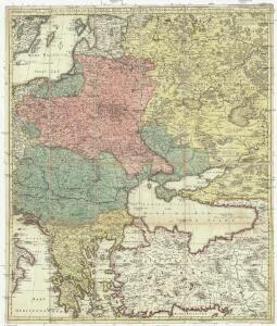
Carte du teatre de la guerre dans la Pologne, Moscovie & Turquie
1 : 3250000 Evropa jihovýchodní Visscher, Nicolaus Schenk, Pieter apud Petrum Schenk
Eastern Europe - communications.
1 : 5300000 John Bartholomew and Son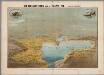
Het oorlogsterrein aan de Zwarte Zee : (vogelperspectief)
Annotatie: Onder de kaart: De toeschouwer stelle zich geplaatst te zijn 300 k.m. boven den Hellespont met het gezicht naar het Noord-Oosten Arnhem : Van Egmond & Heuvelink
Ost- und Mitteleuropa i.d. zweiten Hälfte d. 18. Jahrhunderts. Die polnischen Teilungen
1 : 12000000 Polen-Litauen, Ostmitteleuropa, Teilungen Polens
Spoorwegkaart van Rusland / naar de nieuwste bronnen vervaardigd door J. Pik
1 : 2500000 Annotatie: Met informatie over Russische spoorwegmaatschappijen en over het Russische geld; Annotatie geografische gegevens: Met drie maatstokken: Duitsche mijlen, Kilometers en Wersten J. Pik Groningen : De Financier
Russland um das Jahr 962
1 : 21000000 Russland
Esquisse d’une marche générale des Slaves, du pays des Sauromates vers l’Occident et le Nord-Ouest de l’Europe, du 5e siècle avant notre ère jusqu’au 8e siècle de notre ère
Europa Sarmaten Slawen Völkerwanderungszeit
Europe 3.
1 : 2800000 Anville, Jean Baptiste Bourguignon d, 1697-1782
Uebersicht über die Stabsquartiere der russischen Armee
Russland Militär
Verbreitung der Slaven um 900
Osteuropa Slawen Anton, J.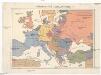
Národopisná mapa Evropy
Evropa Ryšavý, Jaroslav Mollo, Tranquillo
Verbreitung der Slaven um 1400
Osteuropa Slawen Anton, J.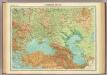
Southern Russia.
1 : 6000000 John Bartholomew and Son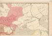
Evropa raného středověku: do konce VI. století po Kr.
Kašpar, Jan
Verbreitung der Slaven um 1900
Osteuropa Slawen Anton, J.
[Secunda Asie tabula] [Karte], in: Clavdii Ptholomei Viri Alexandrini Cosmographie, S. 167.
1 Karte aus Atlas Nicolaus Germanus [und Ptolemaeus, Claudius]
Standorte der höheren Kommandos in Europa und Kaukasus
Russland Russland / Europäischer Teil Kaukasus Militär
Karta razselenija [sic] Slavjan v IX stol
1 : 12600000 Evropa východní Kočubinskij, Aleksandr Aleksandrovič C.I. Mal'cov
Ethnografická mappa
Evropa Merklas, Václav V. Merklas
[Střední a východní Evropa]
Evropa střední
[Střední a východní Evropa]
Evropa střední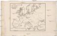
Carte du nord et de l'occident de l'Europe
Evropa Camuccio, Bartholomeo Mansfeld, Johann
Des europäischen Russlands südlicher Theil
Allgemeiner Atlas [Walch, Johannes] im Verlag bei Johannes Walch
Soubor zájezdových map – Svaz Sovětských Socialistických Republik

[Východní Evropa]
Evropa východní
Slovanský zeměvid
Evropa Šafařík, Pavel Josef Merklas, Václav
Slovanský zeměvid
Evropa Šafařík, Pavel Josef Merklas, Václav
Slovanský zeměvid
1 : 4530000 Evropa Šafařík, Pavel Josef Merklas, Václav
Slovanský zeměvid
Evropa Šafařík, Pavel Josef Merklas, Václav
Slovanský zeměvid
Evropa Šafařík, Pavel Josef Merklas, Václav
Slovanský zeměvid
Evropa Šafařík, Pavel Josef Merklas, Václav
Slovanský zeměvid
Evropa Šafařík, Pavel Josef Merklas, Václav
Slovanský zeměvid
Evropa Šafařík, Pavel Josef Merklas, Václav
Slovanský zeměvid
1 : 4530000 Evropa Šafařík, Pavel Josef Merklas, Václav
Slovanský zeměvid
1 : 4530000 Evropa Šafařík, Pavel Josef Merklas, Václav
Slovanský zeměvid
1 : 4530000 Evropa Šafařík, Pavel Josef Merklas, Václav
Slovanský zeměvid
Evropa Šafařík, Pavel Josef Merklas, Václav
Slovanský zeměvid
Evropa Šafařík, Pavel Josef Merklas, Václav
Slovanský zeměvid
Evropa Šafařík, Pavel Josef Merklas, Václav