Maps of Israel

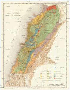
Carte géologique du Liban
1 : 200000 Libanon Zumoffen, G. Barrere, Henry l'Institut Cartographique
Palestine with the Hauran
Jeruzalém Hughes, W. Edward Stanford
Schul-Atlas für die alte Erdbeschreibung : zur allgemeinen Schul-encyclopädie gehörig
J. H. Campe Zusammensetzung und Zeichnung von [...] Dufour, unter Leitung von Heusinger ; gestochen von Frentzel. Braunschweig : Schulbuchhandlung
Palestina čili Kanaan
Palestina Fried, Franz Luther, Th. nákladem Spolku Komenského
The Madaba Map
Jeruzalém Survey of Israel
Aardrijkskundige, plaatsbeschrijvende en geschiedkundige kaart van Palestina of het Heilige land
1 : 281000 oorspronkelijk geteekend door J.T. Assheton [...] bijzonderlijk wat de teekening betreft naauwkeurig herz. en verb. door E. Maaskamp ; onder toezigt en medew. van [...] J. Clarisse Te Amsterdam : bij E. Maaskamp, thans het eigendom van J. C. van Kesteren, boekhandelaar en boekdrukker te Amsterdam
Palestine ou Terre Sainte.
1 : 610000 Lapie, M. (Pierre), 1779-1850
Palaestina
Schul-Atlas der alten Welt bei Justus Perthes
Terra Sancta : vita miraculis et passione Christi consecrata / autore N. Sanson Abbavilleo
1 : 3000000 Sanson, Nicolas [S.l. : s.n.]
Karte von Palaestina
1 : 1030000 Jeruzalém Klöden, Karl Friedrich von Mare, Carl bei August Rücker
A map of Palestine or the Holy Land : with the division into tribes and provinces / by A.H. Dufour
1 : 1100000 Annotatie: Engraved for "Three years in the East". &a Dufour, Auguste Henri [S.l. : s.n.]
[Karte von Palästina]
1 : 500000 Palestina Leway, G.
Palestine.
1 : 1000000 Colton, G.W.
Palestine.
1 : 1650000 Monin, C.V.
Afbeelding van 't land van Israël, naar deszelfs natuurlyke gesteltheid : waar in alle de zeën, rivieren en beeken, gelyk ook de bergen en dalen, de vlaktens, de woestynen, enz. dezes lands, die in de H.S. genoemt zyn, worden aangewezen
1 : 750000 door W.A. Bachiene J. van Jagen sculp. ; J.C. Philips fecit. te Gorinchem : by Nicolaas Goetzee
Bez titulu: Historický Atlas

't Land Kanaan benevens Gilead verdeelt onder de XII stammen Israëls waar in de gelegendheid en uitgestrektheid van ieder erfdeel word aangewezen
1 : 700000 door W.A. Bachiene J. van Jagen mapp. sculpsit, et figur. apposit. sculpturam curavit ; J.C. Philips fecit. Uitgegeven te Gorinchem : by Nicolaas Goetzee
Palästina
Volksschul-Atlas über alle Teile der Erde Lange, Henry Druck und Verlag von Georg Westermann
Palestine.
1 : 1000000 Finley, Anthony
Karte von Palaestina
1 : 384000 Palestina Emmerich, Anna Katharina Riess, Richard Friedrich Pustet
Palestine
1 : 762000 Jeruzalém Hughes, W. Chapman & Hall
Judaea sive Terra Sancta quae Israelitarum suas duodecim tribus distincta, secretis ab invicem regnis Juda, et Israel expressis in super sex ejusdem terrae provincijs
1 : 650000 ex conatibus geographicis Gulielmi Sanson [...] Amst[erdam] : ex officina R. & J. Ottens
Palestine.
1 : 1130000 Tanner, Henry S.
Palestine
1 : 1000000 Colton, G.W.
Judaea seu Terra Sancta quae Hebraeorum sive Israelitarum in suas duodecim tribus divisa, secretis ab invicem regnis Juda, et Israel expressis insuper sex ultimi temporis ejusdem terrae provincijs
1 : 740000 ex conatibus geographicis Gulielmi Sanson [...] A Amsterdam : chez Pierre Schenk
Ancient Palestine.
1 : 760320 Letts, Son & Co.
Terre de Canaan á present la Palestine
1 : 1100000 Kanaán
Terra Sancta, sive promissionis, olim Palestina
1 : 960000 Izrael Wit, Frederick de per Fredericum de Wit
Palestine and the Holy Land.
1 : 930000 Schonberg & Co.