Maps of Israel

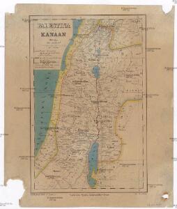
Palestina čili Kanaan
Palestina Fried, Franz Luther, Th. nákladem Spolku Komenského
Schul-Atlas für die alte Erdbeschreibung : zur allgemeinen Schul-encyclopädie gehörig
J. H. Campe Zusammensetzung und Zeichnung von [...] Dufour, unter Leitung von Heusinger ; gestochen von Frentzel. Braunschweig : Schulbuchhandlung
[Karte von Palästina]
1 : 500000 Palestina Leway, G.
Aardrijkskundige, plaatsbeschrijvende en geschiedkundige kaart van Palestina of het Heilige land
1 : 281000 oorspronkelijk geteekend door J.T. Assheton [...] bijzonderlijk wat de teekening betreft naauwkeurig herz. en verb. door E. Maaskamp ; onder toezigt en medew. van [...] J. Clarisse Te Amsterdam : bij E. Maaskamp, thans het eigendom van J. C. van Kesteren, boekhandelaar en boekdrukker te Amsterdam
Palestine ou Terre Sainte.
1 : 610000 Lapie, M. (Pierre), 1779-1850
Palestine.
1 : 1130000 Tanner, Henry S.
Palaestina
Schul-Atlas der alten Welt bei Justus Perthes
Terra Sancta : vita miraculis et passione Christi consecrata / autore N. Sanson Abbavilleo
1 : 3000000 Sanson, Nicolas [S.l. : s.n.]
Karte von Palaestina
1 : 1030000 Jeruzalém Klöden, Karl Friedrich von Mare, Carl bei August Rücker
A map of Palestine or the Holy Land : with the division into tribes and provinces / by A.H. Dufour
1 : 1100000 Annotatie: Engraved for "Three years in the East". &a Dufour, Auguste Henri [S.l. : s.n.]
Palestina seu Terra Sancta. (1826)
1 : 1090000 Tanner, Henry S.
Afbeelding van 't land van Israël, naar deszelfs natuurlyke gesteltheid : waar in alle de zeën, rivieren en beeken, gelyk ook de bergen en dalen, de vlaktens, de woestynen, enz. dezes lands, die in de H.S. genoemt zyn, worden aangewezen
1 : 750000 door W.A. Bachiene J. van Jagen sculp. ; J.C. Philips fecit. te Gorinchem : by Nicolaas Goetzee
Palestine.
1 : 1000000 Finley, Anthony
Palestine.
1 : 1000000 Colton, G.W.
Nova totivs Palestinae sev Terrae Sanctae descriptio pagella vna ita vt bibliorvm volvminibvs congrvat
1 : 755000 Palestina Jenichen, Balthasar Ausfeld, Johann Carl
Wegekarte von Palästina
1 : 800000 Palestina Preußische Landesaufnahme
Palestine.
1 : 1650000 Monin, C.V.
Carte géologique du Liban
1 : 200000 Libanon Zumoffen, G. Barrere, Henry l'Institut Cartographique
Palestine with the Hauran
Jeruzalém Hughes, W. Edward Stanford
Palästina
Volksschul-Atlas über alle Teile der Erde Lange, Henry Druck und Verlag von Georg Westermann
't Land Kanaan benevens Gilead verdeelt onder de XII stammen Israëls waar in de gelegendheid en uitgestrektheid van ieder erfdeel word aangewezen
1 : 700000 door W.A. Bachiene J. van Jagen mapp. sculpsit, et figur. apposit. sculpturam curavit ; J.C. Philips fecit. Uitgegeven te Gorinchem : by Nicolaas Goetzee
Kaart van het Heilige Land ten tijde van Josua en de Regteren
1 : 1100000 S.I. Mulder del. steend. v. C. W. Mieling [Leyden] : D. du Mortier & Fil. excud.
Bez titulu: Historický Atlas

Cesta Israelitů z Egypta a cesty sv. Pavla

Iudaea, seu Terra Sancta quae hebraeorum sive Israelitarum in suas duodecim tribus divisa, secretis ab invicem regnis Iuda, et Israel expressis insuper sex ultimi temporis ejusdem terrae provinciis
1 : 600000 Izrael Sanson, Guillaume Schenk, Pieter Pierre Schenk
Iudaea, seu Terra Sancta quae Hebraeorum sive Israelitarum in suas duodecim tribus divisa, secretis ab invicem regnis Iuda, et Israel expressis insuper sex ultimi temporis ejusdem terrae provinciis
1 : 600000 Izrael Sanson, Guillaume Schenk, Pieter Pierre Schenk
Palestine; Jerusalem.
1 : 660000 John Bartholomew & Co.
Palestine, time of Our Saviour.
1 : 770000 Society for the Diffusion of Useful Knowledge (Great Britain)
Palestine, adjacent districts
1 : 770000 Society for the Diffusion of Useful Knowledge (Great Britain)