Maps of Khabarovsk

Manchuria
1 : 4000000 Mandžusko (Čína) War Office
Manchuria
1 : 4000000 Mandžusko (Čína) Royal Geographical Society
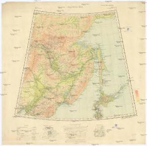
Mandschukuo
1 : 4000000 Mandžusko (Čína) OKH
Charte von der Nordwestküste Americas nach Vancouver
Vancouver-oblast (Britská Kolumbie) Martius, C. von Schwarzmann, I.
Islands of Japan.
1 : 8553600 Fullarton, A. & Co.
Karte von Jesso und Sagalien
Hokkaidó (Japonsko)
Ice Chart, Okhotsk Sea Region, May.
U.S. Navy
Ice Chart, Okhotsk Sea Region, July.
U.S. Navy
Ice Chart, Okhotsk Sea Region, December.
U.S. Navy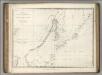
Chart of Discoveries, Made in 1787, in the Seas of China and Tartary, Sheet II.
1 : 6050000 La Perouse, Jean-Francois de Galaup, comte de, 1741-1788
Ice Chart, Okhotsk Sea Region, October.
U.S. Navy
Ice Chart, Okhotsk Sea Region, February.
U.S. Navy
Ice Chart, Okhotsk Sea Region, April
U.S. Navy
Ice Chart, Okhotsk Sea Region, November.
U.S. Navy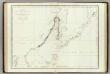
Mers, Chine, Tartarie. 2.
1 : 6250000 La Perouse, Jean-Francois de Galaup, comte de, 1741-1788
Japan, Mandshuria (showing the course of the Amur river), the Kurile Isles &c. : according to the British & Russian Admiralty surveys, Krusenstern, Siebold &c. / by J. Bartholomew Jun.r ; engraved by J. Bartholomew
1 : 9000000 titelvariant: Islands of Japan; Annotatie: Uit: The Royal illustrated atlas of modern geography. - London [etc.] : A. Fullarton & Co., 1860; Lit: A list of geographical atlases, I, no. 838; Titel boven de kaart: Islands of Japan Bartholomew, John (1831-1893) Edinburgh [etc.] : A. Fullarton & Co.
Ice Chart, Okhotsk Sea Region, January.
U.S. Navy
Ice Chart, Okhotsk Sea Region, August.
U.S. Navy
et des Rojaumes de COREE ET IAPAN

Ice Chart, Okhotsk Sea Region, June.
U.S. Navy
Ice Chart, Okhotsk Sea Region, March.
U.S. Navy
Karta Amurského a Přímorského kraje
Amur-oblast (Čína a Rusko) H. Seifert
Carte de la Tartarie orientale
1 : 8000000 1 Karte : Kupferdruck ; 19 x 30 cm [Didot]
43-44. Far East, South. The World Atlas.
1 : 3000000 USSR (Union of Soviet Socialist Republics).
Manchuria. Fu-Shun. Coal Resources of the World.
1 : 6500000 Kido, C.
114-115. China, North-East. The World Atlas.
1 : 3000000 USSR (Union of Soviet Socialist Republics).
U.S.S.R. - Far East, Korea, Japan. Pergamon World Atlas.
1 : 5000000 Polish Army Topography Service
TATARIAE SINENSIS MAPPA GEOGRAPHICA
1 : 5300000 Dálný východ (Rusko) Mayer, Tobias Anville, Jean-Baptiste Bourguinon d' curis Homannianorum Heredum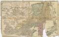
Tatariae Sinensis mappa geographica
1 : 5300000 Dálný východ (Rusko) Mayer, Tobias Anville, Jean-Baptiste Bourguinon d' curis Homannianorum Heredum