Maps of Khabarovsk

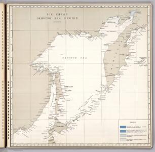
Ice Chart, Okhotsk Sea Region, October.
U.S. Navy
Ice Chart, Okhotsk Sea Region, February.
U.S. Navy
Ice Chart, Okhotsk Sea Region, December.
U.S. Navy
Ice Chart, Okhotsk Sea Region, April
U.S. Navy
Ice Chart, Okhotsk Sea Region, May.
U.S. Navy
Ice Chart, Okhotsk Sea Region, July.
U.S. Navy
Ice Chart, Okhotsk Sea Region, January.
U.S. Navy
Ice Chart, Okhotsk Sea Region, November.
U.S. Navy
Ice Chart, Okhotsk Sea Region, March.
U.S. Navy
Ice Chart, Okhotsk Sea Region, June.
U.S. Navy
Ice Chart, Okhotsk Sea Region, August.
U.S. Navy
Karte von Jesso und Sagalien
Hokkaidó (Japonsko)
Manchuria
1 : 4000000 Mandžusko (Čína) War Office
Manchuria
1 : 4000000 Mandžusko (Čína) Royal Geographical Society
Mers, Chine, Tartarie. 2.
1 : 6250000 La Perouse, Jean-Francois de Galaup, comte de, 1741-1788
Charte von der Nordwestküste Americas nach Vancouver
Vancouver-oblast (Britská Kolumbie) Martius, C. von Schwarzmann, I.
Chart of Discoveries, Made in 1787, in the Seas of China and Tartary, Sheet II.
1 : 6050000 La Perouse, Jean-Francois de Galaup, comte de, 1741-1788
Kamschatka
1 : 4000000 Kamčatka (Rusko)
Mandschukuo
1 : 4000000 Mandžusko (Čína) OKH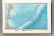
45. Kuril Islands. The World Atlas.
1 : 3000000 USSR (Union of Soviet Socialist Republics).
42. Kamchatka. The World Atlas.
1 : 3000000 USSR (Union of Soviet Socialist Republics).
Plan of the Kurile Islands.
La Perouse, Jean-Francois de Galaup, comte de, 1741-1788
43-44. Far East, South. The World Atlas.
1 : 3000000 USSR (Union of Soviet Socialist Republics).
[Kaart], uit: Ezo kōkyō yochi zenzu
1 : 1200000 Edo : Harimaya Katsugorō
Iles Kuriles, Aleutiennes.
1 : 1900000 La Perouse, Jean-Francois de Galaup, comte de, 1741-1788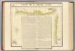
Partie, Russie d'Asie. Asie 27.
1 : 1641836 Vandermaelen, Philippe, 1795-1869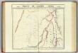
Partie, l'Empire Chinois. Asie 35.
1 : 1641836 Vandermaelen, Philippe, 1795-1869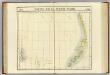
Partie de la Russie d'Asie. Asie 36.
1 : 1641836 Vandermaelen, Philippe, 1795-1869
Partie du Kamtchatka. Asie 37.
1 : 1641836 Vandermaelen, Philippe, 1795-1869
Partie du Japon. Asie 49.
1 : 1641836 Vandermaelen, Philippe, 1795-1869