Maps of Central Serbia
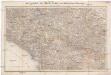
Das Sandschak Novi Bazar, Nord-Albanien, Neu-Serbien u[nd] Montenegro
1 : 864000 Albánie Steinhauser, Anton Artaria
Serbisch-österreichisch-Ungarische Grenzländer
1 : 864000 Albánie Peucker, Karl Scheda, Joseph von Artaria
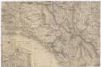
Serbisch-Österreichisch-Ungarische Grenzländer
1 : 864000 Serbien Grenze
[Serben]
Makedonien Ethnische Gruppe Serben
Serbien und Montenegro
1 : 600000 Srbsko Carl Flemming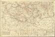
Theatre de la Guerre dans le Royaume de Servie en Originale
Mollova mapová sbírka Weingartner, Johann Heckenauer, August Ferdinand
Serbien und Montenegro
1 : 1000000 Srbsko von Velhagen & Klasing
Strassen- und Eisenbahnkarte des oesterreichischen Kaiserthumes
1 : 864000 Blatt 15 Schaller, G. K.K. Militärisch-Geografisches Institut, Karten-Evidenthaltungs-Abteilung
Internationale Weltkarte 1:1.000.000
1 : 1000000 Evropa jihovýchodní War Office
Serbien und Montenegro
1 : 600000 Srbsko Handtke, Friedrich Carl Flemming
La triangulation trigonometrique de I ere classe
1 : 1500000 Srbsko Bošković, S. P. L'institut Géographique de l'Armée
Karte von Serbien

Carte d'une partie de la Servie et de l'Albanie
1 : 800000 Albánie Lapie, Pierre Schwaerzlé, J. Société géologique de France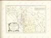
Der Noerdliche Theil Des Koenigreichs Albanien mit dem Distrikte Montenegro
1 : 1400000 Albanien, Montenegro
Karta Nove Srbije
1 : 1200000 Serbien Makedonien Bukarest / Friede <1913> Staatsgrenze Lazić, Ant.
Sheet XIX: Karte Des Oesterreichischen Kaiserstaates.
1 : 576000 Scheda, Josef
Vilayet Prizren/Kosovo (1868-1913)
Kosovo Ejalet, Verwaltungsgliederung Zwick, J. ; Frantz, E.
La Serbie de 1913
Serbien Geschichte
Totius Graeciae descriptio
Griechenland Albanien
[Balkánský poloostrov]
balkánské země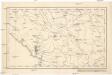
[Černá Hora, Srbsko a Makedonie]
Albánie
Rascien
1 : 800000 Sandschak Novi Pazar , Kosovo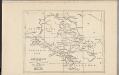
Montenegro
Montenegro
Veles, Priština, Scutari
1 : 750000 Priština (Kosovo) Konrad, A. Erben, Fr. K. u. k. Militärgeographisches Institut
XIX, uit: General-Karte des oesterreichischen Kaiserstaates mit einem grossen Theile der angrenzenden Länder / durch Josef Scheda ... bearb. und hrsg
1 : 576000 Annotatie geografische gegevens: Maatstokken: oesterreichische Meilen, geografische oder deutsche Meilen, preussische Meilen, türkische Berri, französische Lieues, russische Werste; Maatstok per blad: wiener Klafter, öster. Meilen; Blad XIX: statistische en taalkundige informatie; Blad XIX: legenda [Wien : K.K. Militärisch-Geografisches Institut]
Übersichtskarte von Mittel - Europa

Urbinas Handschrift
Albanien Trattato della pittura / Handschrift / Rom / Vatikanische Bibliothek / Cod. Urb. Lat.
Geologishe Übersichtskarte der Österreichischen Monarchie...
![Das Sandschak Novi Bazar, Nord-Albanien, Neu-Serbien u[nd] Montenegro](https://images-2.georeferencer.com/images/iiif/885026739643/full/,300/0/native.jpg)

