Maps of Grand Est

Bojište [sic] 1870
Belgie Bedřich Sandtner
D.O.M. Carte Generale Des Dixsept Provinces des Pays-Bas avec les Frontieres de France, d'Allemagne et Partie de l'Angleterre Nouvellement dreßée sur plusieur Momoires tirés sur les Lieux pendant les Guerres
1 : 750000 Mollova mapová sbírka Sengre, Henri Misson, François Maximilien
Der Deutsch-französische Kriegsschauplatz
1 : 900000 Evropa severozápadní König, Gustav Moriz Perles
Carte Generale des Etats composant La Confederation Germanique.
1 : 2750000 Vivien de St Martin, L.
Westfront
1 : 1100000 [S.l. : s.n.]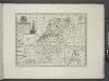
A new map of the Netherlands or Low Countries, shewing their principal divisions, cities, towns, rivers &c.
from A new sett of maps both of antient and present geography : wherein not only the latitude and longitude of many places are corrected according to the latest observations, but also the most remarkable differences of antient and present geography may be quickly discern'd by a bare inspection or comparing of correspondent maps, which seems to be the most natural and easy method to lead young students (for whose use the work is principally intended) unto a competent knowledge of the geographical science : together with a geographical treatise particularly adapted to the use and design of these maps / by Edward Wells, M.A. and student of Christ-Church, Oxon.
Nouvelle carte geographique des postes des Pais Bas, de la Westphalie, & des provinces limitrophes
1 : 1
Germania Parte Occidentale
1 : 2100000 Mollova mapová sbírka Coronelli, Vincenzo Maria
Germania Parte Occidentale
1 : 2100000 Mollova mapová sbírka Coronelli, Vincenzo Maria
West Deutschland und Ost Frankreich, Niederlande und Belgien
1 : 2000000 Belgie Kozenn, B. Hölzel, Eduard Ed. Hölzel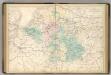
Central Europe.
1 : 2000000 Hughes, William
Carte des peuples riverains du Rhin au temps d’Auguste et de ses successeurs immédiats
Mitteleuropa Rhein-Gebiet ethnische Gruppe Germanen
Unsere Westgrenze
1 : 1000000 Evropa západní Velhagen & Klasing
Soubor map

Royaume des Pays-Bas. Europe 13.
1 : 1641836 Vandermaelen, Philippe, 1795-1869
Charte von Deutschland zu dem Meilen-Zeiger
1 : 222000 Německo Schreiber, Johann Georg
Belli ab obitu Caroli VI. Imperatoris usqve ad pacem Dresdae d. 25. Dec. MDCCXLV
1 : 1300000 Mollova mapová sbírka Kraus, Lorenz Jacob Homann, Johann Baptista - dědici
Europe Centrale (Partie Occidentale).
1 : 1750000 Jouvet et Cie.
Letecká navigační mapa
Skizze zur Orientirung ϋber den Feldzug 1795

Le Cours de la Riviere du Rhein
1 : 1100000 Mollova mapová sbírka Jaillot, Alexis-Hubert Chauveau, François Jaillot, Alexis Hubert
[Königreich der Niederlande]
Neuester Schul-Atlas Walch, Johann im Verlag bei Joh. Walch
Galliæ antiquæ descriptio geographica, 2
1 Blatt : 44 x 57 cm s.n.
West-Duitschland
1 : 840000 Annotatie: Notities in zwart en rood potlood met betrekking tot geallieerde troepenbewegingen eind 1944, begin 1945 [S.l] : [s.n]
Descriptio Germaniae Inferioris. [Karte], in: Theatrum orbis terrarum, S. 162.
1 Karte aus Atlas Ortelius, Abraham Vrients, Jan Baptista
Nouvelle Carte du Royaume des Pays - Bas et Pays Limithropes...

Bez titulu: Severozápadní Evropa
Carte itineraire de l'empire d'Allemagne et des frontieres
1 : 2140000 Německo
Atlas für Handel und Industrie: Für Kaufleute, Fabrikante u. Gewerbetreibende, Handlungs- u. Gewerbe-Schulen
![Bojište [sic] 1870](https://images-2.georeferencer.com/images/iiif/270455161366/full/,300/0/native.jpg)

