Maps of Germany

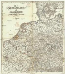
West Deutschland und Ost Frankreich, Niederlande und Belgien
1 : 2000000 Belgie Kozenn, B. Hölzel, Eduard Ed. Hölzel
Dějiště války francouzsko-německé
1 : 2600000 Evropa střední Bedřich Sandtner
Dějiště války francouzské-německé
1 : 2600000 Evropa střední Bedřich Sandtner
Allemagne occidentale.
1 : 2000000 Andriveau-Goujon, J.
Herma
1 : 4000000 Mollova mapová sbírka Weigel, Christoph Wolff, Jeremias
Postarum seu Cursorum Publicorum diverticula et mansiones per Germaniam et Confin. Provincias
1 : 2500000 Mollova mapová sbírka Seutter, Matthäus Rein, Melchior Seutter, Matthäus
Teutschland In seine 10. Kreise abgetheilt
1 : 2700000 Mollova mapová sbírka Wolf, Jeremias Wolff, Jeremias
Dějiště války francouzsko-německé
1 : 2600000 Evropa střední
Deutsches Reich
Volksschul-Atlas über alle Teile der Erde Lange, Henry Druck und Verlag von Georg Westermann
Bojiště francouzsko-německé
Evropa severozápadní Gréger a Ferd. Dattel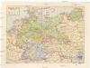
Deutsches Reich
1 : 3250000 Evropa střední Staatliche Verlagsanstalt
Feuille 24 (C IV), uit: Carte géologique internationale de l'Europe : la carte, votée au congrès géologique international de Bologne en 1881, est exécutée conformément aux décisions d'une commission internationale, avec le concours des gouvernements, sous le dir. de M.M. Beyrich et Hauchecorne
Annotatie: Blad 48 gamme des couleurs; blad 49: bladwijzer en titelblad Heinrich Ernst Beyrich 1815-1896; Wi. Hauchecorne Berlin : Reimer / (Berlin: Institut lithographique)
Charte von Deutschland zu dem Meilen-Zeiger
1 : 222000 Německo Schreiber, Johann Georg
Map of the German Empire.
1 : 3700000 Warner & Beers
Die Ältesten Karten von Deutschland
[Střední Evropa]
Evropa střední
Der Deutsch-französische Kriegsschauplatz
1 : 900000 Evropa severozápadní König, Gustav Moriz Perles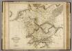
Germania Antiqua.
1 : 2500000 Playfair, Principal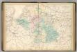
Central Europe.
1 : 2000000 Hughes, William
Mappa geographica exhibens postas omnes tam vehiculares quam veredarias totius Germaniae
Evropa střední Lotter, Tobias Conrad Tobias Conrad Lotter
Mappa geographica exhibens postas omnes tam vehiculares quam veredarias totius Germaniae
Evropa střední Lotter, Tobias Conrad Tobias Conrad Lotter
Mappa geographica exhibens postas omnes tam vehiculares quam veredarias totius Germaniae
Evropa střední Lotter, Tobias Conrad Tobias Conrad Lotter

L'Allemagne Divisée en Havte et Basse, et par Cercles, Subdivisée en Etats Ecclesiastiques, Laiques et Villes Imperiales
1 : 2400000 Mollova mapová sbírka Du Tralage, Jean Nicolas Nolin, Jean Baptiste
Mappa Geographica indicans, quibus in locis per totam Germaniam bello tricennali Rex Sueciae Gustavus Adolphus, ejusque Confoederati felicia ut plurimum praelia comiserint, quas urbes tenuerint et A. 1648 amore Pacis vi tractatum Westphalicarum restituere promiserint
1 : 2500000 Mollova mapová sbírka Seutter, Matthäus Seutter, Matthäus
S. Imperium Romano-Germanicum oder Teutschland mit seinen angräntzenden Königreichen und Provincien
1 : 2420000 Evropa střední Reichelt, Julius Hogeboom, A. durch Nicolaum Visscher
S. Imperium Romano-Germanicum oder Teutschland mit seinen angräntzenden Königreichen und Provincien
1 : 2450000 Evropa střední Reichelt, Julius Hogeboom, Andries durch Nicolaum Visscher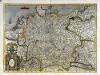
Germania
1 Karte : Kupferdruck ; 34 x 47 cm Mercator; Hondius Henricus Hondius
Germania
1 Karte : Kupferdruck ; 34 x 47 cm Mercator s.n.