Maps of Niedersachsen

Atlas für Handel und Industrie: Für Kaufleute, Fabrikante u. Gewerbetreibende, Handlungs- u. Gewerbe-Schulen

Nouvelle Carte du Royaume des Pays - Bas et Pays Limithropes...

Tabula generalis totius Belgii
1 : 1000000 Belgie Homann, Johann Baptist á Iohanne Baptista Homanno
TABULA GENERALIS TOTIUS BELGII qua PROVINCIAE XVII. INFER. GERMANIAE olim sub S.R.I. CIRCULO BURGUNDIAE
1 : 1100000 Belgie Homann, Johann Baptist â Iohanne Baptista Homanno
Tabula generalis totius Belgii
1 : 1000000 Belgie Homann, Johann Baptist á Iohanne Baptista Homanno
Tabula generalis totius Belgii
1 : 1000000 Belgie Homann, Johann Baptist â Iohanne Baptista Homanno
Royaume des Pays-Bas. Europe 13.
1 : 1641836 Vandermaelen, Philippe, 1795-1869
Soubor map

Naauwkeurige kaart van het oude Nederland en eenige aangrenzende gewesten.
1 : 2000000 Isaak Tirion. Te Amsterdam : by Isaak Tirion
[Nordwestliches Deutschland, Kgr. Der Niederlande, Kgr. Belgien]
Hand-Atlas über alle Theile der Erde nach dem neuesten Zustande und über das Weltgebäude Stieler, Adolf bei Justus Perthes
D.O.M. Carte Generale Des Dixsept Provinces des Pays-Bas avec les Frontieres de France, d'Allemagne et Partie de l'Angleterre Nouvellement dreßée sur plusieur Momoires tirés sur les Lieux pendant les Guerres
1 : 750000 Mollova mapová sbírka Sengre, Henri Misson, François Maximilien
Nouvelle carte geographique des postes des Pais Bas, de la Westphalie, & des provinces limitrophes
1 : 1
Nord-Westliches Deutschland, Niederlande und Belgien
Hand-Atlas über alle Theile der Erde und über das Weltgebäude Stieler, Adolf Justus Perthes
Der Deutsch-französische Kriegsschauplatz
1 : 900000 Evropa severozápadní König, Gustav Moriz Perles
Nord-Westliches Deutschland, Niederlande und Belgien
Handatlas über alle Theile der Erde und über das Weltgebäude Stieler, Adolf Justus Perthes
[Nordwestliches Deutschland, Kgr. der Niederlande, Kgr. Belgien]
Hand-Atlas über alle Theile der Erde nach dem neuesten Zustande und über das Weltgebäude Stieler, Adolf bei Justus Perthes
Charte von dem Schiefer Gebirge des nordwestlichen Deutschlands Belgiens und des nordöstlichen Frankreichs
1 : 1150000 Ardeny Raumer, Carl von Guimpel, F.

Nord-Westliches Deutschland, Niederlande Und Belgien.
1 : 1850000 Vogel, C.
Germania Parte Occidentale
1 : 2100000 Mollova mapová sbírka Coronelli, Vincenzo Maria
Germania Parte Occidentale
1 : 2100000 Mollova mapová sbírka Coronelli, Vincenzo Maria
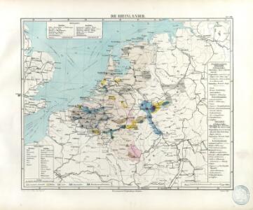
Unsere Westgrenze
1 : 1000000 Evropa západní Velhagen & Klasing
Galliæ antiquæ descriptio geographica, 2
1 Blatt : 44 x 57 cm s.n.
Belgii Veteris Typus. [Karte], in: Theatrum orbis terrarum, S. 470.
1 Karte aus Atlas Ortelius, Abraham Vrients, Jan Baptista
[Nordwestliches Deutschland und Kgr. Der Niederlande]
Stieler's Hand-Atlas Stieler, Adolf bei Justus Perthes
Bez titulu: Severozápadní Evropa

Europe Centrale (Partie Occidentale).
1 : 1750000 Jouvet et Cie.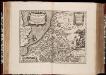
Belgii veteris typus : ex conatibus geographicis Abrahami Ortelij
1 : 1400000 Annotatie: Gegraveerd door Pieter van den Keere; De kaart geeft de Nederlanden weer in de tijd van de Romeinen; Origineel is Blad 33 in atlas factice; Kopie van de kaart van Abraham Ortelius uit 1584; Annotatie geografische gegevens: Met schaalstok Pieter van den Keere 1571-ná 1646; Abraham Ortelius 1527-1598 [Amsterdam : C.J. Visscher excudebat]
Belgii Veteris Typus [...] [Karte], in: Gerardi Mercatoris et I. Hondii Newer Atlas, oder, Grosses Weltbuch, Bd. 1, S. 361.
1 Karte aus Atlas Mercator, Gerhard und Hondius, Jodocus Jansson, Jan