Maps of Bavaria

Cercle de Baviere
1 : 1100000 Bavorsko (Německo) Mentelle, Edme Tardieu, Pierre François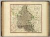
Bavaria.
1 : 835000 Cary, John, ca. 1754-1835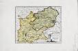
Das Herzogthum Ober und Nieder Bayern
1 Karte : Kupferdruck ; 22 x 27 cm Reilly F. J. J. von Reilly
Boioaria aetate romanorvm collata cvm hodierna
1 Karte : Kupferdruck ; 24 x 29 cm Braun; Zimmermann Ruprecht
[Atlas zur Geschichte von Bayern] : IV. Die Herzogthümer Baiern, Franken, und ein Theil von Alemannien im XII & XIII Jahrhundert nach erblichen Grafschaften & Gebieten getheilt
K. v. Spruner [Gotha : Perthes]
Salisbvrgensis Ivrisdictionis, locorumque vicinorum vera descriptio
1 : 730000 Mollova mapová sbírka Setznagel, Marx Rade, Gillis van den
Circulus Bavaricus
1 Karte : Kupferdruck ; 56 x 48 cm Valck; Valck Valck
[Atlas zur Geschichte von Bayern] : II. Die Gauen von Bojoaria, Franconia, und eines Theils von Alemannia vom VIIIten bis in’s XIte Jahrhundert
K. v. Spruner [Gotha : Perthes]
[Atlas zur Geschichte von Bayern] : VII. Das Königreich Bayern nach seinen gegenwärtigen Bestandtheilen mit allen Gebiets-Veränderungen von 1801 bis 1816
K. v. Spruner W. Hase sc. Weimar [Gotha : Perthes]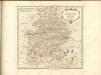

Circulus Bavaricus, in qua Archiep. Saltzburgi, Episc. Ratisbonae, Passaviae et Freisingiae. Praep. Bergtolsgadiae. Ducat. Superior. et Inferior. Bavariae, et Neoburgi; Comitat. Palatinus. et Landgrav. Luchtenbergae.
1 : 675000 Mollova mapová sbírka Valk, Gerhard Valck, Gerard
Charte vom Königreiche Bayern
1 : 1040000 Bavorsko (Německo) Güssefeld, Franz L. Ehnlich, I. F. C. im Verlag des Geograph. Instituts
Cesta, kudy Hus ubíral se do Kostnice
Mitteleuropa Konstanz Reiseweg Hus, Jan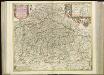
[51][51] Circulus Bavaricus ..., uit: Atlas sive Descriptio terrarum orbis
Annotatie: Gedigitaliseerde versie. Amsterdam. Heiloo : Picturae (vervaardiger), 2015. tiff-bestand. Gedigitaliseerd: 07-01-2015; Origineel: Universiteitsbibliotheek Vrije Universiteit (XL.05127.-) ; Netherlands; Titelpagina ontbreekt Wit, Frederik de Amsterdam : Frederick de Wit
Königreich Bayern
1 : 1284000 Bavorsko (Německo) Tranquillo Mollo
Charte vom Königreiche Bayern
Bavorsko (Německo) Streit, Friedrich Wilhelm
CHARTE vom KÖNIGREICHE BAYERN
Bavorsko (Německo)
Charte vom Königreiche Bayern
Bavorsko (Německo)
Chur-Bayern im Jahr 1804
1 : 1083000 Bavorsko (Německo) Herdegen, J. C. F. Leizel, Balthasar Friedrich J.L.C. Rheinwald
Teutschlandes Bayerischer Creiss samt dazu gehörigen Provintzen
1 : 2500000 Mollova mapová sbírka Weigel, Johann Christoph Weigel, Christoph I.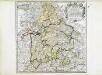
Bayern
1 Karte : Kupferdruck ; 41 x 41 cm Sanson; Cordier chez l'autheur
Karte vom Königreich Baiern
1 : 1100000 Bavorsko (Německo) in A.G. Schneider u. Weigels k. priv. Kunst- u. Landkartenhandlung
Postkarte von Bayern, Würtemberg und Baden nebst Theilen der angrenzenden Laender
Bavorsko (Německo) Loehle, Franz Franz Loehle
CHARTE vom KÖNIGREICHE BAYERN
Bavorsko (Německo)
Chur=Baiern
1 Karte : Kupferdruck ; 46 x 55 cm Riegel zu finden bey Christoph Riegel
Bavaria.
1 : 1650000 Bowen, Frances
Circulus Bavariae in suas quasque ditiones tam cum finitimis, quam insertis regionibus accuratissime divisus
1 : 632000 Bavorsko (Německo) Seutter, Matthäus a Matthaeo Seutter
Circulus Bavariae in suas quasque ditiones tam cum finitimis, quam insertis regionibus accuratissime divisus
1 : 632000 Bavorsko (Německo) Seutter, Matthäus Matthaeo Seutter
Carte du duché et electorat de Baviere
1 Karte : Kupferdruck ; 40 x 46 cm Brion de la Tour; Chambon; Esnault; Rapilly chez Esnauts et Rapilly rue S. Jacques a la ville de Coutances


